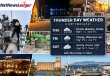

Three-day weather forecast for November 21–23, 2026, covering Thunder Bay, Kakabeka Falls, Oliver Paipoonge, Neebing, Shuniah and surrounding communities
NetNewsLedger Weather Desk | Saturday, November 21, 2026 | Morning Edition
THUNDER BAY, ON — Santa Claus is coming to town, and Mother Nature seems to have decided to give him a break from the North Pole!
Thunder Bay is looking at an unusually mild Saturday, with temperatures expected to climb to 13°C. That is welcome news for thousands of families heading to Memorial Avenue for today’s Rotary Santa Claus Parade, although there is a chance of rain during the morning.
The warm weather will not last. Sunday brings a return to cooler temperatures and a chance of flurries, while Monday will feel much more like late November, with temperatures below freezing.
For residents in Kakabeka Falls, Murillo, Rosslyn, Neebing, Shuniah and surrounding rural communities, the biggest concern will be the change from wet conditions Saturday to colder weather Sunday night and Monday morning.
Thunder Bay Three-Day Forecast
Sat, Nov. 21
13°C
Cloudy, showers
Low 2°C
Sun, Nov. 22
4°C
Chance of flurries
Low -9°C
Mon, Nov. 23
-2°C
Sun and cloud
Low -10°C
34th Annual Rotary Santa Claus Parade
10:00 a.m. start
Memorial Avenue, Thunder Bay
68%
Rain chance at 10AM means having your rain gear at hand.
Parade Route and Road Closures
The Rotary and Rotaract Clubs of Thunder Bay are bringing the annual Christmas parade back to Memorial Avenue today, with festive floats, marching groups and Santa Claus.
The parade begins at the Real Canadian Superstore near Harbour Expressway, travels north along Memorial Avenue and finishes at the Thunder Bay Community Auditorium.
Motorists should plan ahead. The City of Thunder Bay has confirmed:
-
9 a.m. to noon: Memorial Avenue will be closed between 13th Avenue and High Street.
-
Beverly Street will be closed between High Street and Newton Street.
- Thunder Bay Transit routes 3M Memorial, 8 James and 15 Beverly will operate on detours during that period.
- For families, today’s advice is simple: bring a rain jacket, choose comfortable waterproof shoes and give yourself extra time to find parking.
The weather should be mild enough that heavy winter parkas may not be necessary, but children standing in one place for an extended period can still feel chilly, especially if their clothing gets wet.
A warm drink, a small umbrella and some extra mittens for younger children could make the morning more enjoyable.
Parade Morning Hour-by-Hour Outlook
| Time | Temperature | Expected conditions |
|---|---|---|
| 8 a.m. | 10°C | Cloudy |
| 9 a.m. | 11°C | Cloudy |
| 10 a.m. | 12°C | Chance of showers |
| 11 a.m. | 12°C | Cloudy |
| Noon | 12°C | Chance of showers |
| 1 p.m. | 13°C | Showers possible |
The parade-day forecast is certainly more comfortable than a bitter November freeze. However, a mild temperature is no guarantee of a dry parade, so spectators should be prepared for rain.
Official parade information: Rotary Santa Claus Parade. Transit detours: City of Thunder Bay Service Alerts.
Saturday, November 21 — Mild but Damp
Thunder Bay can expect cloudy skies with a 40 per cent chance of drizzle during the morning, changing to a 40 per cent chance of showers in the afternoon.
Southwest winds near 20 km/h will become light around noon.
The high will reach 13°C, well above the normal late-November high of approximately 0°C.
The UV index will be 1, or low.
Saturday Night — Cooling Begins
Cloudy skies will continue overnight, with a 40 per cent chance of drizzle.
North winds near 20 km/h will develop around midnight, bringing cooler air into the area.
The overnight low will be approximately 2°C.
For drivers heading outside Thunder Bay, watch for wet pavement and changing temperatures after dark.
Sunday, November 22 — A Return to Flurries
Sunday will be noticeably colder.
Environment Canada is forecasting cloudy skies with a 60 per cent chance of flurries.
The daytime high will be approximately 4°C.
With temperatures hovering above freezing during the day, snow may melt on contact with warmer pavement, but rural and elevated areas could cool more quickly.
Sunday Night — Temperatures Fall Sharply
Sunday night will bring cloudy skies and a 60 per cent chance of flurries.
Temperatures will fall to approximately -9°C.
That is a significant change from Saturday’s mild conditions.
Residents should watch for icy sidewalks, parking lots and rural roads where moisture remains.
Monday, November 23 — Sunshine and Winter Temperatures
Monday will bring a mixture of sun and cloud.
The high will reach only -2°C, making it a much colder day than Saturday.
Monday night will be clear, with temperatures falling to approximately -10°C.
Winter jackets, warm gloves and insulated footwear will once again be part of the daily routine.
For motorists, Monday morning could bring icy patches, especially on bridges, shaded roads and untreated rural routes.
Surrounding Communities: Kakabeka Falls, Murillo, Rosslyn and Oliver Paipoonge
Saturday’s mild weather will extend across much of the rural Thunder Bay area. However, the transition to colder temperatures could arrive sooner in inland communities.
Kakabeka Falls and Murillo
Saturday will be cloudy with a chance of rain or drizzle and a daytime high near 13°C to 14°C.
Sunday brings the possibility of rain showers or flurries as colder air arrives. Temperatures could hover near freezing.
Monday will be brighter but cold, with daytime temperatures around -4°C.
Residents should prepare for slippery rural roads, especially Sunday night and Monday morning.
Neebing, South Gillies and Rosslyn
Saturday should bring mild, cloudy conditions, with occasional drizzle or showers possible.
Sunday will be cooler, with the possibility of flurries across inland areas.
By Monday, sunshine should return, although temperatures will remain below freezing.
Rural roads and driveways may become slippery as leftover moisture freezes.
Shuniah, Pass Lake and Dorion
Communities northeast of Thunder Bay will also experience mild Saturday weather before colder air arrives.
A chance of showers will continue through Saturday, followed by rain or snow Sunday.
Monday will be colder, with a mixture of sun and cloud and some flurries possible.
Nipigon, Red Rock and Lake Helen
Saturday will bring cloudy skies, a 40 per cent chance of showers or drizzle and a high near 13°C.
Sunday will be much cooler, with a 70 per cent chance of rain or snow and temperatures near 1°C.
Sunday night will fall to approximately -11°C.
Monday will be cloudy with a chance of flurries and a high near -4°C.
Regional Weather and Travel Summary
| Community | Saturday | Sunday | Monday |
|---|---|---|---|
| Thunder Bay | 13°C, showers possible | 4°C, flurries possible | -2°C, sun and cloud |
| Kakabeka Falls | Mild, showers possible | Near freezing, mixed precipitation | Around -4°C, sunny |
| Neebing and South Gillies | Mild, cloudy, possible drizzle | Cooler, flurries possible | Below freezing, brighter |
| Shuniah and Pass Lake | Mild, showers possible | Rain or snow possible | Cold, some clearing |
| Nipigon and Red Rock | 13°C, showers or drizzle | 1°C, rain or snow | -4°C, chance of flurries |
Thunder Bay, Kakabeka Falls and Nipigon forecasts are based on retrieved Environment Canada guidance. Conditions for the smaller surrounding communities are regional estimates rather than independently verified forecasts for each location.
Highway and Road Safety: Watch for Changing Conditions
The major concern over the next three days is the shift from mild and wet conditions Saturday to temperatures well below freezing by Monday.
Roads to watch include Highway 11/17 through Shuniah, Highway 61 south of Thunder Bay, Highway 102, Highway 130 toward Kakabeka Falls and Highway 11/17 toward Nipigon.
Drivers heading out of town Sunday evening or Monday morning should be prepared for black ice, particularly on bridges and shaded stretches of pavement.
For updated provincial road conditions, check Ontario 511 before leaving.
What to Wear: From Parade Jackets to Winter Parkas
Saturday is a rain-jacket day, with temperatures unusually mild for late November.
Sunday calls for warmer clothing, particularly if you are spending time outdoors.
By Monday, winter jackets, gloves and insulated footwear should be back in regular use.
And for those attending the Christmas parade today, remember that Santa might be accustomed to North Pole temperatures, but standing along Memorial Avenue in wet shoes is nobody’s idea of holiday cheer!
Weather Trivia: Why Is Saturday So Warm?
Thunder Bay’s normal daytime high for late November is around 0°C.
Saturday’s forecast high of 13°C is approximately 13 degrees above that seasonal normal.
The mild weather is associated with warmer air moving into the region ahead of a change in the weather pattern.
Once winds shift and colder air arrives, temperatures can drop quickly.
That is exactly what the forecast suggests will happen between Saturday and Monday.
Looking Ahead
Tuesday, November 24, should bring sunshine and a high near 0°C in Thunder Bay, with another cold night expected.
For now, enjoy Saturday’s mild temperatures, support the Rotary Clubs of Thunder Bay and welcome Santa Claus to town.
The winter weather will be back soon enough!
NetNewsLedger Publishing Information
SEO Headline: Thunder Bay Weather November 21–23: Mild Christmas Parade Saturday Before Cold Returns
Social Media Hashtags: #ThunderBay #ThunderBayWeather #SantaClausParade #RotaryThunderBay #ChristmasParade #MemorialAvenue #KakabekaFalls #Shuniah #NorthwesternOntario #NetNewsLedger