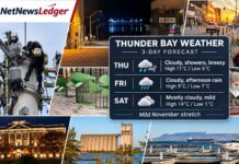

Three-day forecast for November 20–22, 2026, covering Thunder Bay, Kakabeka Falls, Oliver Paipoonge, Neebing, Shuniah, Pass Lake, Dorion, Red Rock and Nipigon
NetNewsLedger Weather Desk | Friday, November 20, 2026 | Morning Edition
THUNDER BAY, ON — Weather Desk – Well the weather of the past fews days has been a welcome respite from the usual November weather, however it appears as of Friday morning the city is headed back to more seasonally conditions.
Mother Nature appears ready to wake up Old Man Winter, at least for the next few days. With El Niño and the Polar Vortex mixing up the weather who really knows?
Right now, Thunder Bay and surrounding communities are heading into a weekend of major weather changes, with unusually warm November temperatures, rain showers and a sharp return to freezing conditions.
Friday will bring cloudy skies, morning fog in some locations and temperatures reaching approximately 8°C. Saturday could be remarkably mild, with Environment and Climate Change Canada’s latest forecast calling for a high of 14°C in Thunder Bay.
That is about 14 degrees above the normal daytime high for this time of November.
However, winter is preparing a comeback. By Sunday, temperatures will fall toward freezing, with rain showers or flurries possible. Sunday night could see temperatures drop to -10°C in Thunder Bay and even lower in some inland communities.
So for Saturday’s Rotary Christmas Parade the message will be bundle up.
For residents planning outdoor activities, shopping, yard work or weekend travel, Saturday will feel more like October. Sunday will remind everyone that December is approaching.
Thunder Bay Three-Day Forecast at a Glance
Friday, Nov. 20
8°C
Cloudy, drizzle possible
Night: near 7°C
Saturday, Nov. 21
14°C
40% chance of showers
Night: -1°C
Sunday, Nov. 22
0°C
60% chance of mixed showers
Night: -10°C
Based primarily on Environment Canada’s 5:30 a.m. EST forecast of November 20, 2026. Forecasts are subject to change.
Friday, November 20 — Cloudy Skies and Mild Temperatures
Thunder Bay starts Friday morning under mostly cloudy skies, with temperatures around 4°C.
Fog and low clouds could affect parts of the city and surrounding rural communities during the early morning.
Environment Canada forecasts cloudy skies with a chance of drizzle or rain during the day.
The high will reach 8°C.
The UV index will be 1, or low.
Friday Night — Rain Chances Increase
Cloudy skies will continue, with a 70 per cent chance of showers in the updated morning forecast.
Temperatures will remain well above freezing, with an overnight low listed near 7°C.
Warmer air moving into the region ahead of Saturday’s weather system could cause temperatures to rise overnight.
Residents heading out for Friday evening activities should bring a waterproof jacket.
Saturday, November 21 — November Warmth Comes with Showers
Saturday will be the warmest of the three forecast days.
Environment Canada calls for a high near 14°C in Thunder Bay, with a 40 per cent chance of showers.
Other current forecast guidance also supports a high around 14°C, although the timing and duration of rainfall may vary.
For late November, that is an unusually warm day.
The weather could provide an opportunity for residents to finish outdoor chores, prepare Christmas decorations or take a walk along the waterfront. However, showers could interrupt those plans.
Saturday Night — Temperatures Drop Sharply
Saturday evening brings the beginning of a major weather change.
Temperatures will fall toward -1°C overnight, with a 60 per cent chance of rain showers or flurries.
Any water left on untreated surfaces could begin freezing as temperatures drop.
Residents should pay particular attention to driveways, steps, sidewalks and parking lots.
Sunday, November 22 — Winter Makes Its Return
Sunday will feel considerably colder.
Environment Canada’s forecast calls for cloudy skies and a 60 per cent chance of rain showers or flurries.
The daytime high will reach approximately 0°C.
Some other forecasting guidance suggests temperatures could briefly rise to around 4°C, but Environment Canada’s outlook indicates a colder day.
Sunday night will become much colder, with a 60 per cent chance of flurries and a low near -10°C.
That represents a dramatic temperature change from Saturday’s warmth.
For anyone heading out Sunday evening, winter coats, gloves and insulated boots will be back on the wardrobe list.
Weather Across Thunder Bay’s Outlying Communities
The same weather system will affect much of the Thunder Bay District, but temperatures can vary considerably between Lake Superior’s shoreline and inland communities.
Regional Three-Day Temperature Outlook
| Community | Fri. Nov. 20 | Sat. Nov. 21 | Sun. Nov. 22 |
|---|---|---|---|
| Thunder Bay | 8°C | 14°C | 0°C |
| Kakabeka Falls | 7°C | 9°C | -2°C |
| Nipigon | 7°C | 12°C | 1°C |
| Atikokan | 7°C | 11°C | -1°C |
Kakabeka Falls, Murillo and Oliver Paipoonge
Residents west of Thunder Bay can expect cloudy conditions Friday, with temperatures near 7°C.
Rain becomes more likely Friday night and Saturday, followed by a rapid drop in temperatures.
The latest retrieved Kakabeka Falls forecast calls for a Saturday high of 9°C, although that forecast was issued a day earlier than Thunder Bay’s updated outlook.
Saturday night will bring a 60 per cent chance of flurries or rain showers, with a low near -3°C.
Sunday will be cloudy, with a 60 per cent chance of flurries and a high around -2°C.
Sunday night could see temperatures drop to -13°C.
The inland location means freezing conditions may develop sooner than along Lake Superior.
Neebing, South Gillies and the Highway 61 Corridor
Communities south and southwest of Thunder Bay should experience a similar progression from mild weather to colder conditions.
Friday will be cloudy, with some rain or drizzle possible.
Saturday’s mild temperatures may be accompanied by showers.
Saturday night and Sunday will bring the greatest concern for slippery surfaces as temperatures fall toward or below freezing.
Residents travelling Highway 61 or rural municipal roads should prepare for wet pavement followed by possible freezing conditions.
Shuniah, Pass Lake and Highway 11/17 East
Shuniah and Pass Lake can expect cloudy conditions Friday, with the possibility of drizzle or light showers.
Saturday will be mild, but rain will become more likely as the weekend system moves through.
By Sunday, temperatures will fall sharply, with mixed rain and snow possible.
Higher terrain and shaded rural road sections could become slippery as temperatures drop.
Dorion, Red Rock and Nipigon
Nipigon’s retrieved Environment Canada forecast calls for cloudy skies Friday, with a chance of drizzle in the morning and showers late in the afternoon. The high will reach 7°C.
Southeast winds may increase to 20 km/h, gusting to 40 km/h.
Friday night will remain unsettled, with a 60 per cent chance of showers and temperatures rising overnight.
Saturday will bring showers and a high near 12°C.
Saturday night will see temperatures drop to -1°C, with a 60 per cent chance of rain showers or flurries.
Sunday will bring a 70 per cent chance of rain or snow, with a high near 1°C.
Sunday night could fall to -11°C.
Red Rock and Dorion should experience a similar regional pattern, but local precipitation and temperature details may differ.
Highway Travel Outlook: Watch Saturday Night and Sunday
Friday — Morning fog and wet pavement
Fog and drizzle could reduce visibility around Thunder Bay and rural highways. Rain chances increase later Friday and overnight.
Saturday — Mild but rainy
Temperatures will be well above freezing, but showers could leave highways wet. Drivers should leave additional following distance.
Sunday — Freezing conditions return
Rain or wet snow may create slippery conditions. Bridges, shaded sections of highway and untreated rural roads deserve particular attention.
Motorists travelling Highway 11/17, Highway 61, Highway 102 or Highway 130 should check Ontario 511 before leaving.
The forecast indicates possible driving hazards, not confirmed highway closures.
What to Wear: From Fall Jackets to Winter Boots
Friday will be mild enough for a fall jacket, although waterproof footwear and an umbrella will be useful where showers occur.
Saturday’s high of 14°C means residents may be comfortable in a sweater or lightweight jacket during the warmer hours. Keep rain gear nearby.
Sunday will be different. Temperatures near freezing and the possibility of flurries mean winter coats, gloves and warm hats will be sensible choices.
For families preparing to head outdoors Sunday evening, insulated boots will be particularly helpful.
Weather Trivia: Why Is Thunder Bay Warmer Than Kakabeka Falls?
Lake Superior plays an important role in the region’s autumn weather.
Water loses heat more slowly than land. During late autumn, the lake can help moderate temperatures in nearby communities.
Inland areas such as Kakabeka Falls, Murillo and South Gillies do not always receive the same warming influence.
That can produce noticeable temperature differences over relatively short distances, especially during colder nights.
Looking Ahead: Sunshine Returns, but Temperatures Remain Cold
Monday, November 23, should bring an improvement in sky conditions across Thunder Bay.
Environment Canada forecasts sunshine with a high near -2°C.
Monday night will be clear and cold, with temperatures falling toward -11°C.
Tuesday should also be sunny, with a high near -1°C.
The much colder conditions will be closer to what residents normally expect in late November.
The bottom line: Thunder Bay and surrounding communities will enjoy mild temperatures Friday and Saturday, but rain and a sharp temperature drop will bring winter driving and outdoor safety concerns by Sunday.
#ThunderBay #ThunderBayWeather #KakabekaFalls #OliverPaipoonge #Shuniah #Nipigon #NorthwesternOntario #WinterWeather #NetNewsLedger