
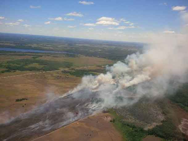
THUNDER BAY – WILDFIRE Update – The fire season across Northeastern Ontario has far more active fires. There are over sixty active fires across the region.
Time of Report 19:10
By late afternoon, there were sixty-one active forest fires across the Northeast. Twenty-eight of these fires are not yet under control, while thirty-three is either being held, under control or being observed.
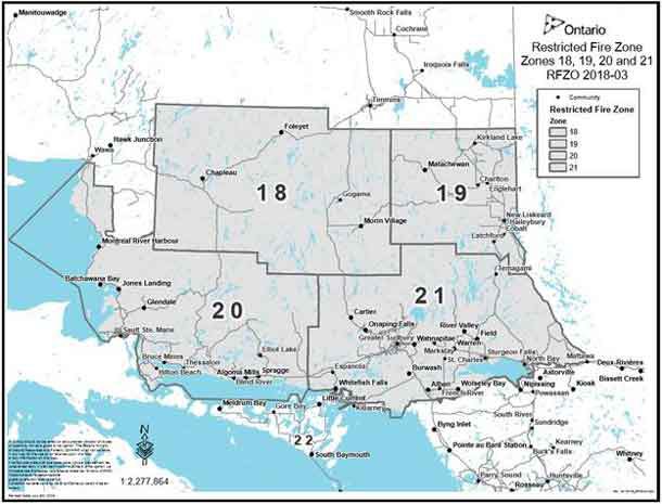
Restricted Fire Zone declared in Northeast Region
Due to the extreme fire hazard, several recent periods of heavy lightning and the large number of wildfires burning, the Ministry of Natural Resources and Forestry has declared a Restricted Fire Zone in some areas of Northeastern Ontario effective at 12:01 a.m. July 7 (Restricted Fire Zones 18, 19, 20 and 21) outlined in the map below.
During a Restricted Fire Zone, the use of open fires – such as campfires, or burning of brush or debris, is restricted. Failure to comply could result in fines of up to $25,000 and three months in jail, as well as financial responsibility for the costs incurred in fighting a forest fire.
Portable gas or propane stoves are permitted for use for cooking or warmth, though they should be closely monitored. Portable charcoal BBQs and Hibachis are not permitted unless within 100 metres of a dwelling, or within an organized campground.
Commercial campground operators may allow their guests to enjoy campfires during a Restricted Fire Zone period provided they meet certain conditions.
The Restricted Fire Zone is a temporary measure to reduce the number of new human-caused wildfires as the Aviation Forest Fire and Emergency Services branch of the OMNRF expects the elevated forest fire hazard to continue into the foreseeable future.
Seventeen new starts from today remain active, others have already been declared out at the time of this update. Of note, ten of these new and active fires are located within the North Bay sector.
- North Bay 38 covers 0.5 of a hectare and is not yet under control. It is located approximately 8 km north of Tomiko Lake, south of Temagami River Provincial Park.
- North Bay 42 is located just outside of the border of Temagami River Provincial Park, approximately 3 km northwest of Red Cedar Lake. It covers 0.4 of a hectare and is not yet under control.
- North Bay 43 is located between Porcupine Lake and Cut Lake. It is being held at 0.2 of a hectare.
- North Bay 44 is located 1.5 km southwest of Hwy 11 North, just north of Holdridge Lake. It covers 0.2 of a hectare and is not under control at this time.
- North Bay 45 covers 0.2 of a hectare, is not yet under control and is located 2 km southwest of Hand Lake.
- North Bay 46, located in Obabika River Park, approximately 5 km west of Willow Island Lake. It covers 0.1 or a hectare and is not yet under control at the time of this update.
- North Bay 47 covers 1.5 hectares and is not under control. It is located approximately 2 km south of Dry Lake.
- North Bay 48 covers 6 hectares and is located on the south side of Hwy 558, west of the junction between Hwy 11 north and Hwy 558. It is not yet under control at this time.
- North Bay 49 covers 0.6 of a hectare, is located east of Banks Lake within Lady Evelyn-Smoothwater Provincial Park. It is not yet under control at this time.
- North Bay 50 is being held at 0.1 of a hectare. It is located west of Hwy 805, west of Sturgeon River Provincial Park.
- Chapleau 11 covers 4 hectares. It is not under control and it is located northwest of Mississagi River Provincial Park.
- Chapleau 12 covers 0.1 of a hectare. It is not yet under control at the time of this update and is located southeast of Upper Green Lake.
- Sault 8 is located near Depot Lake, west of Hwy 108, approximately 5 km southeast of Elliot Lake. It covers 4 hectares and is not yet under control.
- Sudbury 51 is located approximately 1.5 km north of Pothier Road northwest of St.Charles. It covers 4 hectares and is not yet under control at the time of this update.
- Sudbury 52 is located in Killarney Provincial Park on the southeast shore of David Lake. It is not yet under control.
- Sudbury 53, located north of Garson Lake, is being held at 0.4 of a hectare.
- Aviation, Forest Fire and Emergency Services responded to a fire outside of the fire region today after a request for assistance from Ramara Fire Department. Midhurst 2 is located approximately 8 km east of Beaverton. AFFES assisted the municipal fire department with aerial fire suppression: four CL415 waterbombers and 1 bird dog aircraft were on scene this afternoon. The fire is approximately 20 hectares and it is not yet under control. The Ramara Fire Department is now on scene.
The forest fire hazard has been predominantly high to extreme in the Northeast region this afternoon, It is expected that the fire hazard will be high to extreme across the Northeast region again tomorrow.
Help fight forest fires – Stay clear of waterbombers:
When waterbombers approach a body of water, move close to the shore so they can perform their scoop safely.
A waterbomber will not scoop from a lake or river if encroaching watercraft pose a safety hazard.
Fire numbers and online information:
- To report a forest fire located north of the French and Mattawa rivers, please dial 310-FIRE (3473)
- To report a forest fire located south of the French or Mattawa rivers, please dial 911.
- Follow us on Twitter: in English @ONForestFires or in French @ONFeuDeForêt
- For up to date information on current fires in the province or to check the forest fire hazard in your area, visit Ontario.ca/forestfire
For guidelines on safe outdoor fire management ontario.ca/fireprevention
Report prepared by Isabelle Chenard


