
Weather Conditions Changing With Storm Watch
THUNDER BAY – Updated 20:25EDT -Environment Canada has issued a severe Thunder Storm Watch for Thunder Bay and much of Northwestern Ontario.
Severe Thunderstorm Watch for:
- =new= City of Thunder Bay
- =new= Kenora – Nestor Falls
- =new= Dryden – Ignace
- =new= Fort Frances – Rainy Lake
- =new= Atikokan – Upsala – Quetico
- =new= Superior West.
The Weather Service at 18:45 updated their Severe Thunder Storm Warning. “This is an alert to the potential development of severe thunderstorms with large hail, damaging winds or heavy rainfall..Monitor weather conditions and listen for updated bulletins.
“Warm and humid air remains entrenched across Northwestern Ontario. A potent upper level disturbance currently over Southern Manitoba will track eastwards through this evening and generate scattered thunderstorms ahead of it. A few of these thunderstorms may become severe with large hail and damaging winds the primary threats. Heavy rainfall in excess of 50 mm is also possible”.
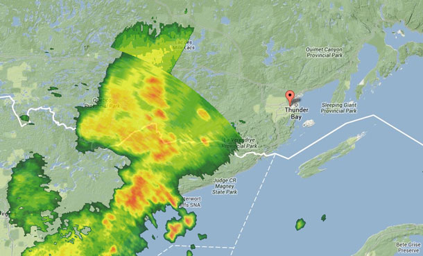
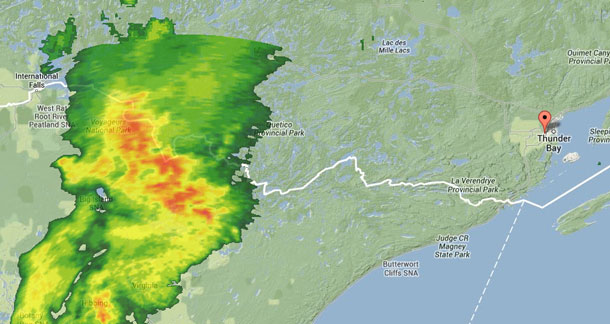
There is a large storm system off to the west of Thunder Bay.
International Falls Minnesota is under a Severe Thunder Storm Watch as well. The US Weather Service reports, “These storms are capable of producing up to nickel size hail… wind gusts up to 50 mph… frequent cloud to ground lightning… and brief heavy downpours… a few storms may be severe storms with damaging winds and large hail”.
This is an alert to the potential development of severe thunderstorms with large hail, damaging winds or heavy rainfall..Monitor weather conditions and listen for updated bulletins.
Warm and humid air remains entrenched across Northwestern Ontario. A potent upper level disturbance over Southeastern Saskatchewan will track eastwards through this evening and generate scattered thunderstorms ahead of it. A few of these thunderstorms may become severe with large hail and damaging winds the primary threats. Heavy rainfall in excess of 50 mm is also possible.


