
Northwest Region Sees Surge in Wildfire Activity
THUNDER BAY – Wildfire Update – The Northwest Region of Ontario is facing a significant escalation in wildfire incidents. As of the late afternoon of June 24, four new fires have been confirmed, adding to the region’s ongoing firefighting challenges. In total, there are now 44 active fires in the Northwest Region, with 12 of them remaining uncontrolled, 4 being held, 5 under control, and 23 under observation.
Northwest Region
- There were four new fires confirmed in the Northwest Region by the late afternoon of June 24:
- Sioux Lookout 53 is located approximately 6.1 kilometres east of the community of Bearksin Lake on the shoreline of the Severn River. The 0.1 hectare fire is not yet under control.
- Thunder Bay 24 (3.5 hecatres) and Thunder Bay 25 (0.1 hectares) are located in the centre of Wabakimi Provincial Park, west and north of Whitewater Lake respectively. Both fires are not yet under control.
- Dryden 23 is located on the west side of Highway 599, near Fourbay Lake. The 0.1 hectare fire is not yet under control.
- Eight additional fires were confirmed following the previous update during the evening hours of June 23.
- Sioux Lookout 51 is a remote fire, located approximately 11.2 kilometres east of Wigwascene Lake. The 80 hectare fire is currently being observed.
- Sioux Lookout 52 is located on an island in Severn Lake, approximately 12 kilometres southeast of the community of Bearksin Lake. The 0.3 hectare fire is not yet under control.
- Nipigon 24 is located along the Attiwapiskat River, on the northern edge of Otoskwin-Attawapiskat River Provincial Park. The 824.6 hectare fire is currently being observed.
- Nipigon 25 is located approximately 2 kilometres west of Wapikopa Lake, and 60 kilometres west of Webequie. The 5.0 hectare fire is currently being observed.
- Nipigon 26 is located approximately 32.7 kilometres northwest of Kasabonika. The 800 hectare fire is currently being observed.
- Kenora 27 is located on the north shore of Canyon River, approximately 11.6 kilometres east of Highway 671. The 1.5 hectare fire is now being held.
- Red Lake 38 was located approximately 15 kilometres northeast of Trout Lake. The 0.1 hectare fire is now out.
- Red Lake 39 was located approximately 38.6 kilometres northwest of Red Lake, near the eastern edge of Woodland Caribou Provincial Park. The 0.2 hectare fire is now out.
- At the time of this update there are 44 active fires in the Northwest Region; 12 of these fires are not under control, 4 fires are being held, 5 fires are under control and 23 fires are being observed.
- The wildland fire hazard is mainly high across the Northwest Region, with pockets of extreme hazard in the centre and Far North, and low to moderate hazard along the Minnesota border.
- For a closer look at fire hazard conditions in your area and an overview of regional fires, view the Interactive Map.
Northwest Fires of Note
- Sioux Lookout 7 is located north of Cat Lake First Nation and is 16,002.8 hectares in size. Hose lines have been established on the southern end of the fire while the northern section is being monitored. The fire remains not under control.
- Sioux Lookout 33 is located on the western edge of Wabakimi Provincial Park and is 41,548 hectares in size. Values assessment and protection is ongoing. The fire remains not under control.
- Nipigon 13 is located west of Ogoki Lake and is now 23,084 hectares in size. Values assessment and protection is ongoing. Successful ignition operations took place yesterday on the fire. The fire remains not under control.
- Nipigon 19 is located northwest of Ogoki Lake and is 8,705.8 hectares in size and not under control. The fire was showing aggressive fire behaviour yesterday and will be reassessed for ignition opportunities. The fire remains not under control.
- Red Lake 28 is located 50 kilometers North of Lac Seul First Nation and is 16,040 hectares in size. Values assessment and protection is ongoing. The fire remains not under control.
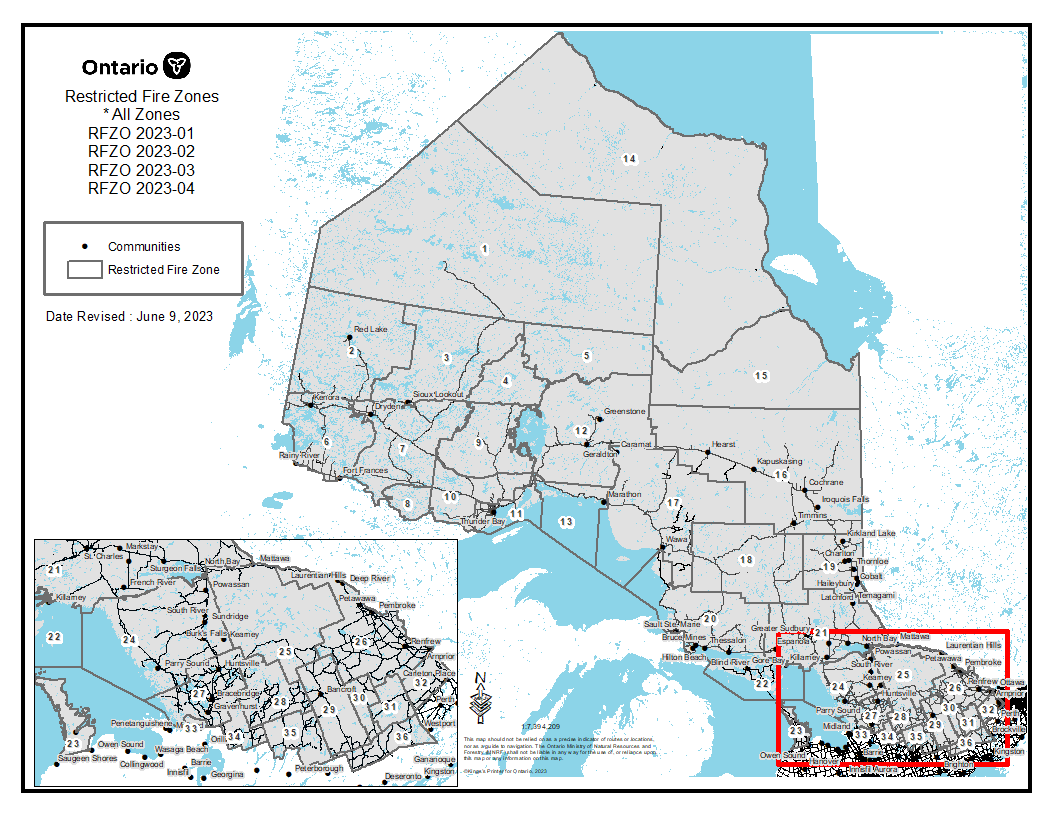
Restricted Fire Zone
Due to the extreme forest fire hazard, the Ministry of Natural Resources and Forestry has declared a Restricted Fire Zone for the entire fire region of Ontario (Zones 1 to 36). The Restricted Fire Zone is in effect until further notice. Restricted Fire Zones help protect public safety. Open air burning, including campfires, is not permitted within the boundaries of a Restricted Fire Zone. Portable gas or propane stoves may be used for cooking and warmth BUT must be handled with extreme caution. All burning permits are suspended.
Click the link for a map of areas affected by the Restricted Fire Zone.
Report a Wildland Fire
To report a wildland fire located north of the French and Mattawa rivers, please dial 310-FIRE. To report a forest fire located south of the French or Mattawa rivers, please dial 911.


