
Northeast Region Wildfire Update
There are currently 23 active wildland fires in the Northeast Region. Of these, 11 are not under control, 2 are being held, 8 fires are under control and one is being observed.
- The two fires which have been exhibiting the most intense fire behavior today are Cochrane 7 and Cochrane 11.
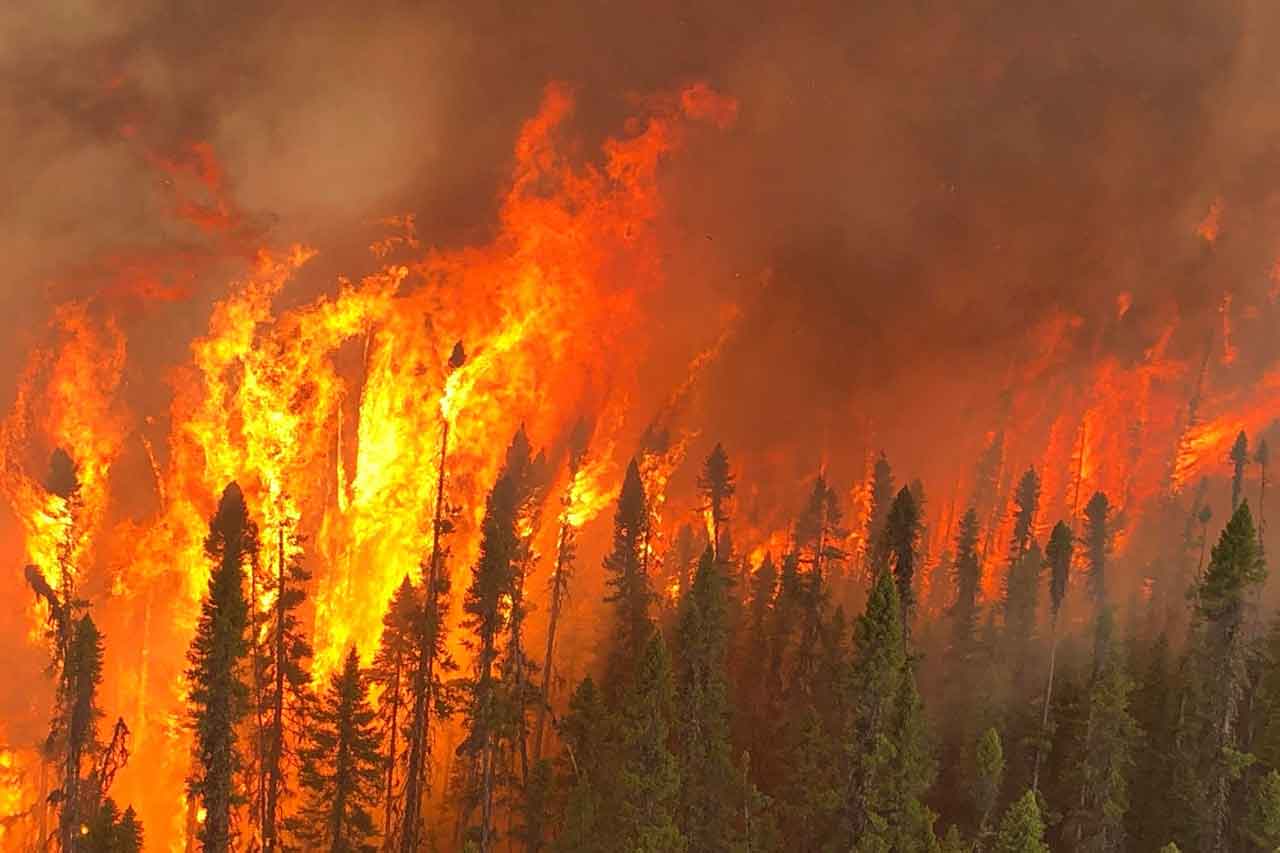
- Cochrane 7 was confirmed on June 2. It is a 11,908 hectare wildland fire is located northeast of Lake Abitibi and 7 kilometres southwest of Joe Lake. Intense fire behavior has been noted on Wednesday. There are 8 helicopters, heavy equipment and fire crews dedicated to this fire which is not under control.
(Intense fire behavior exhibited by Cochrane 7 this afternoon, photo provided by Jamie Gaunt, Fire Management Technician at the Cochrane Fire Management Headquarters)
-
- Cochrane 11 was confirmed on June 17. It estimated at 300 hectares and is located west of the community of Fort Albany and south of Big Island. The fire’s intensity increased rapidly throughout the afternoon today and a team of aerial fire suppression aircraft (including fixed-wing and rotary-wing) have been working on the active wildland fire which is not under control.
- The fire hazard is high to extreme across the vast majority of the Northeast Region this afternoon.
Other fires of note:
- Chapleau 3 was confirmed on June 1. It is a 3,916 hectare wildland fire located 2 kilometres south of October Lake and 2.5 kilometres west of Vichaw Lake. It is not under control.
- Chapleau 6 was confirmed on June 4. It is a 1,229 hectare wildland fire located 2.5 kilometres west of Morin Lake and 1 kilometre east of Bolkow Lake. It is not under control.
- Cochrane 6 was confirmed June 2. It is a 1,239 hectare wildland fire located 9 kilometres west of Lake Abitibi and 1 kilometre east of Marathon Lake. This fire is holding along cat guards, roads, and natural boundaries. It is not under control.
- Kirkland Lake 5 was confirmed on June 7. It is a 2,300 hectare wildland fire located north of Lady Evelyn Lake. Helicopters and personnel continue to work on this fire which is not under control.
- Sudbury 10 was confirmed on June 2. It measures 1,370 hectares and is located 3 kilometres west of Fox Lake and 5 kilometres east of Acheson Lake. It is not under control.
- Sudbury 17 was confirmed June 4. It is a 5,857 hectare wildland fire located 3 kilometres west of Madawanson Lake and 0.5 kilometres east of Pilot Lake. Multiple crews are committed to the fire. It is not under control. Travel, use and access restrictions related to this fire have been modified. the information as well as a new map by the MNRF’s Sudbury District office can be found below.
- Sudbury 19 was confirmed on June 4. It is a 459 hectare wildland fire located south of Shakwa Lake and 1 kilometre west of Lower Shakwa Lake. It is under control.
- Timmins 7 was confirmed on June 4. It is a 149 hectare wildland fire located 0.3 kilometres northeast of Ahsine Lake. It is now being held.
- Wawa 3 was confirmed on May 27. It is a 6,678 hectare wildland fire located south of Trent Lake and Round Lake, and 5 kilometres northwest of Duffy Lake. It is being held. Travel, use and access restrictions related to this fire have been revoked.
Implementation Orders
Please note that the travel, use and access restrictions that had been in place due to the WAW003 fire in the Northeast Region’s MNRF Chapleau-Wawa District under EAO 2023-01 have now been revoked.
Travel, use, and access Restrictions in the Northeast Region – MNRF Sudbury District
Under the Emergency Area Order (EAO 2023-04) declared on June 5, 2023, the MNRF Sudbury District has put in an Implementation Order to protect public safety and facilitate effective fire suppression. The following restrictions listed and as outlined on the Implementation Order map are now in effect until further notice:
- All travel and use of Highway 810 (also known as the Massey Tote Road) south of Ritchie Falls at UTM Zone 17 East 403972 North 5174771, and north of Madawanson Lake Rd at UTM Zone 17 East 409250 North 5158217 is prohibited unless authorized by a Travel Permit issued by the Sudbury District Ministry of Natural Resources and Forestry
- All persons are prohibited from entering the area indicated on the attached map unless authorized by a travel permit issued by the Ministry of Natural Resources and Forestry.
For more information on these restrictions, see the Implementation Order map. If you have questions regarding travel and access restrictions, please contact the Sudbury District Office at 705-564-7823
Travel, use, and access Restrictions in the Northeast Region – MNRF Hearst-Cochrane-Kapuskasing District (COC005, COC006 COC007 fires):
- Under the Emergency Area Order (EAO 2023-03) effective June 5 at 7:01 a.m., 2023, the MNRF, Hearst-Cochrane-Kapuskasing District has put in an Implementation Order to protect public safety and to facilitate effective fire suppression. The following restrictions listed below and as outlined on the Implementation Order are now in effect until further notice. All travel and use of the following areas is prohibited unless authorized by a travel permit issued by the MNRF Hearst-Cochrane-Kapuskasing District:
- Translimit Road and Crossover Roads eastwards beginning where the roads intersect at UTM Zone 17 East 571137 North 5436902
- Translimit Road west of the Ontario-Quebec border at UTM Zone 17 East 608042 North 5423187 to the Translimit-Crossover Road control point
- Bingle Road south of where it intersects with the former CN Rail Line at UTM Zone 17 East 545352 North 5421478
- All use and occupation of Crown Land and roads within Marathon Township south of the former CN Rail Line
- All use and occupation of Crown Land and roads within Bowyer Township south of the former CN Rail Line
- All use and occupation of Crown lands and roads within the Townships of: Moody, Galna, Knox, Kerrs, Steele, Berry, Sargeant, Bonis, Scapa, Hepburn, Abbotsford, and Adair.
For more information on these restrictions, see the Implementation Order Map. If you have any questions or require travel permits, please contact the Hearst-Cochrane-Kapuskasing District office at 705-272-7178 or by email mnrf.coc@ontario.ca
Travel, use and access Restrictions in the Northeast Region – MNRF Chapleau-Wawa District (CHA003 fire):
- Under the Emergency Area Order (EAO 2023-05) declared on June 9, 2023, the Ministry of Natural Resources and Forestry, Chapleau-Wawa District has put in an Implementation Order for the CHA003 fire to protect public safety and to facilitate effective fire suppression. The following restrictions listed below and as outlined on the Implementation Order Map, are now in effect until further notice. All travel and use of the following areas is prohibited unless authorized by a Travel Permit issued by the Chapleau-Wawa District Ministry of Natural Resources and Forestry (MNRF):
- Dore Road (Foleyet Timber Road) south of UTM 17 North, East 381644, North 5300986
- Jerome Road north of the Sultan Industrial Road, UTM 17 North, East 396782, North 5266107
- Mallard Road north of the Sultan Industrial Road, UTM 17 North, East 395324, North 5266100, and
- Dore Road (Foleyet Timber Road) north of the Sultan Industrial Road, UTM 17 North, East 387440, North 5273197.
For more information on the travel and use restrictions, see the Implementation Order Map. If you have any questions or require travel permits, please contact the Chapleau-Wawa District Office at 705-856-2396.
Report a Wildland Fire
To report a wildland fire located north of the French and Mattawa rivers, please dial 310-FIRE. To report a forest fire located south of the French or Mattawa rivers, please dial 911.


