Carlsbad may be one city, but driving conditions can change considerably from one part of town to another.
A trip through Carlsbad Village can involve pedestrians, cyclists, restaurants, businesses and visitors navigating relatively compact streets. Travel farther east or south, and drivers encounter wider arterial roads, larger intersections and routes connecting residential communities with Interstate 5 and employment centers.
Understanding these differences is an important part of understanding road safety in Carlsbad.
Carlsbad Village and the Coast
Carlsbad Village is one of the city’s most recognizable areas.
The combination of shops, restaurants, residences, rail access and nearby beaches creates a transportation environment shared by motorists, pedestrians and cyclists.
Carlsbad Boulevard is especially important because it connects coastal destinations while carrying local and visitor traffic.
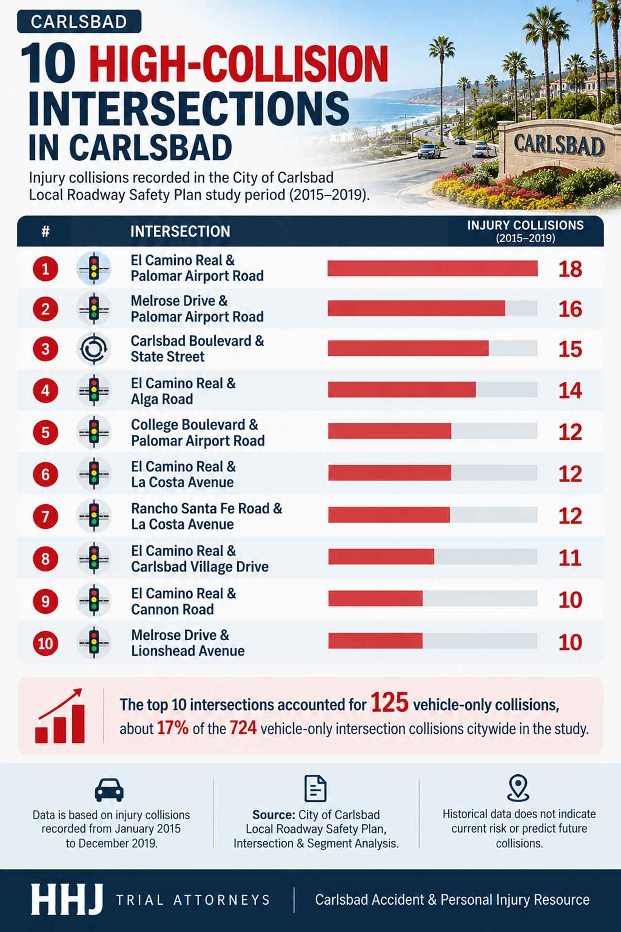
The intersection of Carlsbad Boulevard and State Street was among the locations identified in the City of Carlsbad’s historical roadway-safety analysis.
That doesn’t mean residents should consider the area unsafe. Instead, it illustrates the complexity of transportation in a popular mixed-use coastal environment.
El Camino Real Connects Multiple Parts of Carlsbad
Moving inland, El Camino Real plays a different role.
It is one of Carlsbad’s major north-south transportation corridors and intersects with several significant east-west roads.
Historical collision data identified multiple intersections along El Camino Real, including those at Palomar Airport Road, Alga Road, La Costa Avenue, Carlsbad Village Drive and Cannon Road.
For residents traveling between neighborhoods, shopping areas and businesses, these intersections are familiar parts of daily life.
Their appearance in historical safety analysis demonstrates why major arterial corridors receive significant attention from transportation planners.
La Costa and Southern Carlsbad
The La Costa area presents another transportation environment.
La Costa Avenue provides an important east-west connection and intersects with El Camino Real and Rancho Santa Fe Road.
Residential communities, schools, recreation areas and commercial destinations generate different traffic patterns throughout the day.
Morning and afternoon school traffic may differ considerably from evening or weekend travel.
That variation is one reason collision statistics should always be considered alongside the broader characteristics of a neighborhood.
Palomar Airport Road and the Business Corridor
Palomar Airport Road connects Interstate 5 with a large concentration of businesses and employment centers.
The corridor also provides access to shopping destinations, McClellan-Palomar Airport and surrounding communities.
Its intersections with El Camino Real, College Boulevard and Melrose Drive appeared in historical roadway-safety analysis.
Unlike a neighborhood street, Palomar Airport Road often carries vehicles traveling longer distances through Carlsbad, making it an important part of the city’s overall mobility network.
Mapping Carlsbad’s Different Transportation Environments
Seeing these locations on a map can provide context that a list of street names cannot.
An interactive Carlsbad road-safety map developed by HHJ Trial Attorneys allows residents to explore major intersections, roads, community destinations and emergency resources across the city.
The resource can be viewed at: https://hhjtrialattorneys.com/carlsbad-personal-injury-accident-map/
Rather than ranking neighborhoods by safety, the map is intended to help residents understand how different roads and intersections fit into Carlsbad’s broader transportation network.
Road Safety Is a Citywide Responsibility
Whether someone is driving through Carlsbad Village, commuting along Palomar Airport Road or traveling through La Costa, the basic principles remain the same.
Drivers should stay alert, follow posted speed limits, give pedestrians and cyclists adequate space and avoid distractions behind the wheel.
Pedestrians and cyclists also benefit from remaining visible and predictable, particularly around busy intersections.
Carlsbad’s neighborhoods may have different transportation characteristics, but everyone using the road plays a role in making them safer.
Interactive Carlsbad Map: View the Carlsbad Accident Map
Local Resource
Media Contact:
Company Name: HHJ Trial Attorneys: Car Accident & Injury Lawyers
Address: 2175 Salk Ave Ste 180,
City: Carlsbad
State: CA
ZIP Code: 92008
Country: United States
Phone: +1 760-444-0275
Website URL – https://hhjtrialattorneys.com/carlsbad-personal-injury-lawyer/
Social Media:
https://www.facebook.com/767566010105041
@hhjtrialattorneys
https://www.instagram.com/hhjtrialattorneys/
https://www.youtube.com/@619injured