WINNIPEG – WEATHER Desk – Winnipeg is a weather city of contrasts. From brutal cold in winter to the heat and humidity of summer weather in Winnipeg can be extreme.
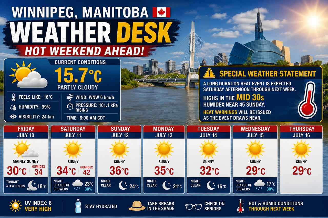
Winnipeg starts Friday with a mild and very humid morning, sitting near 16°C under partly cloudy skies. The day will quickly warm, with sunshine, a high of 30°C, and a humidex near 34.
Environment Canada has issued a Special Weather Statement for the City of Winnipeg, warning that a long-duration heat event is expected to begin Saturday afternoon and last well into next week.
Today’s Weather Overview
Current Conditions
At 6:00 AM CDT, Winnipeg reported partly cloudy skies with a temperature of 15.7°C. The dew point was 15.5°C, and humidity was extremely high at 99 percent, giving the morning a damp and muggy feel.
Winds were from the west-northwest at 6 km/h, visibility was 24 km, and the barometric pressure was 101.1 kPa and rising.
Today’s forecast calls for sunny skies, with fog patches dissipating this morning. There is a risk of a thunderstorm late this afternoon. The high will reach 30°C, with a humidex of 34. The UV index is 8, or very high.
Special Weather Statement
Long-Duration Heat Event Expected
A long-duration heat event is expected over much of southern Manitoba and southern Saskatchewan beginning Saturday afternoon and lasting well into next week.
For Winnipeg, temperatures will approach 30°C today, then climb into the mid-30s by the end of the weekend. Conditions will become especially muggy, with humidex values possibly approaching 45 on Sunday in parts of southern Manitoba.
Heat warnings are expected to be issued as the event draws closer.
Weekend Forecast
Expected Conditions
Tonight: Skies will clear late this evening. There is a risk of a thunderstorm early this evening. The overnight low will be 18°C.
Saturday, July 11: Winnipeg will see sunny skies, with winds becoming south at 30 km/h in the afternoon. The high will climb to 34°C, with a humidex near 42. The UV index remains 8, or very high. Saturday night brings cloudy periods with a 30 percent chance of showers and a very warm low of 23°C.
Sunday, July 12: Sunday is expected to be the hottest day of the weekend, with sunny skies and a high of 36°C. Sunday night will be clear and very warm, with a low of 24°C.
Monday, July 13: Hot weather continues with sunshine and a high near 35°C. Monday night clears again, with a low of 21°C.
Heat Safety
This weekend’s heat should be taken seriously. Drink water often, even before you feel thirsty. Limit strenuous outdoor activity during the hottest part of the day, and look for shade or air-conditioned spaces when possible.
Watch for signs of heat exhaustion, including headache, nausea, dizziness, thirst, dark urine, and intense fatigue. Move to a cooler place and drink water if symptoms develop.
Heat stroke is a medical emergency. Call 9-1-1 if someone has red, hot skin, confusion, dizziness, nausea, or a change in consciousness.
Never leave children, vulnerable people, or pets inside a parked vehicle.
Wardrobe Recommendations
Wear lightweight, light-coloured, loose-fitting clothing today and through the weekend. A wide-brimmed hat, sunglasses, and sunscreen are strongly recommended with the UV index in the very high range.
For Saturday and Sunday, plan outdoor activities early in the morning or later in the evening. Keep water with you, especially at parks, festivals, sports fields, or outdoor job sites.
Weather Trivia
A humidex above 40 means the body has a harder time cooling itself because sweat does not evaporate as efficiently. That is why Saturday’s forecast high of 34°C could feel closer to 42°C, and Sunday may feel even hotter across southern Manitoba.
Overview: Winnipeg weather for July 10, 2026: partly cloudy and 16°C early, sunny with a high of 30°C today, then a long-duration heat event builds Saturday through next week with humidex values near 42 to 45.