Northwest Fire Region Reports 76 Active Wildland Fires, Five New Starts Confirmed
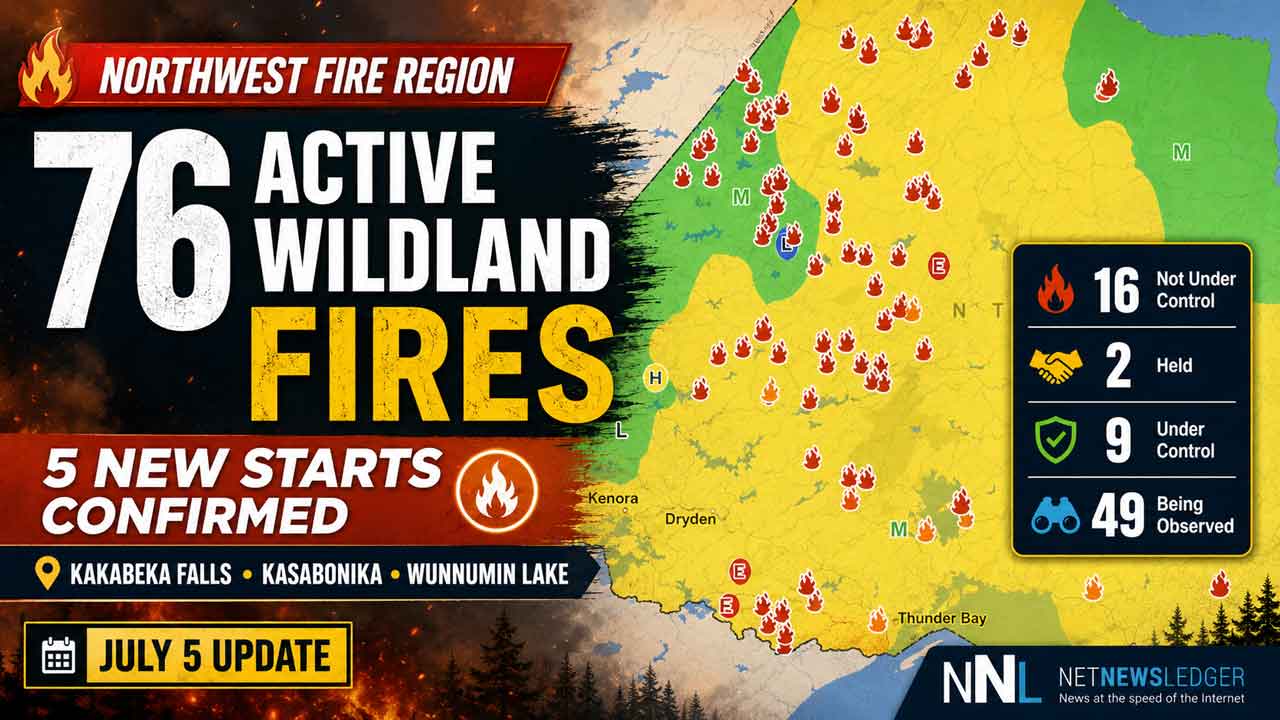
THUNDER BAY — Ontario’s Northwest Fire Region is reporting 76 active wildland fires as of the early evening of July 5, with five new fires confirmed across the region.
Aviation, Forest Fire and Emergency Services says 16 fires are not under control, two are being held, nine are under control and 49 are being observed. Two fires were called out over the past 24 hours.
Five new fires confirmed July 5
Five new wildland fires were confirmed in the Northwest Region by 6:24 p.m. CDT.
Dryden 21 is located near the eastern shore of Harmon Lake, about 109 kilometres north of Upsala. The fire is two hectares and is not under control.
Thunder Bay 34 is located within the community of Kakabeka Falls. The fire is 0.1 hectares and is not under control.
Nipigon 26 is located near Oakley Lake in a remote area about 65 kilometres west of Neskatanga First Nation. The 250-hectare fire is being observed.
Sioux Lookout 59 is located at the Allanwater Bridge, about 38 kilometres east of Savant Lake. The 0.1-hectare fire is under control.
Sioux Lookout 58 is located near the east shore of Kezik Lake, about 10 kilometres north of Slate Falls First Nation. The fire is four hectares and is not under control.
Fort Frances 14 remains not under control near Byers Lake
Fort Frances 14 remains a fire of note. It is located about 35 kilometres southwest of Upsala near Byers Lake.
Fourteen FireRanger crews and five helicopters are assigned to the fire. Two heavy helicopters with increased bucketing capacity joined fire operations Sunday.
A drying trend continues in the area, and fire operations staff are monitoring for increasing fire behaviour.
The fire has been remapped to a more accurate and smaller size of 1,480 hectares. It remains not under control.
Kasabonika Lake First Nation Complex continues under active response
Additional crews have been added to firefighting operations around the Kasabonika Lake First Nation Cluster.
A total of 12 FireRanger crews, eight fire management personnel, three helicopters and two fixed-wing aircraft are assigned to the cluster.
Crews are establishing hose lines on the western and northern perimeters of the priority fire, Nipigon 16. Bucketing helicopters supported FireRanger crews Sunday and also worked to suppress flare-ups on Nipigon 13.
A drying trend over the past few days has crews watching for increased fire behaviour and possible new starts from recent lightning strikes.
Nipigon 16 is 1,474.2 hectares and remains not under control.
Nipigon 12, located about 20 kilometres west of Kasabonika Lake First Nation, is listed at 2,119 hectares.
Three additional active fires remain in the area surrounding Kasabonika Lake First Nation.
Nipigon 13 is not under control and has been remapped to 500.4 hectares. Nipigon 14 is not under control at two hectares. Nipigon 15 is not under control at 0.1 hectares.
Sioux Lookout 21 remains active near Wunnumin Lake First Nation
Sioux Lookout 21 remains 357 hectares and is not under control.
The fire is located about nine kilometres south of the Wunnumin Lake First Nation Airport.
Six FireRanger crews and three helicopters are assigned to the fire.
NOTAMs remain in effect near Kasabonika and Wunnumin Lake
A NOTAM remains in place in the area of Nipigon 16 near Kasabonika Lake First Nation. A second NOTAM remains in place near Sioux Lookout 21 near Wunnumin Lake First Nation.
These restrictions are in addition to standard airspace restrictions under section 601.15 of the Canadian Aviation Regulations. Airspace around all active forest fires is restricted to forest fire suppression aircraft only within five nautical miles and up to 3,000 feet above ground level.
Pilots are reminded to check Nav Canada’s Collaborative Flight Planning Services under the “Weather and NOTAM” tab when planning flights.
Regional impact across Northwestern Ontario
The July 5 fire update highlights the continued pressure wildland fires place on Northwestern Ontario communities, especially remote First Nations where air access is critical for emergency response, medical travel, supplies and possible evacuations.
For communities such as Thunder Bay, Kakabeka Falls, Sioux Lookout, Upsala, Savant Lake, Slate Falls and areas near Lake Nipigon, wildfire activity can affect air quality, aviation, tourism, forestry, highways and emergency planning.
The new fire within Kakabeka Falls also serves as a reminder that wildland fire risk is not limited to remote areas. Even small fires near populated communities can require quick response and public caution.
Outdoor fire rules remain in effect
Ontario’s legislated fire season runs from April 1 to Oct. 31.
Aviation, Forest Fire and Emergency Services is reminding the public to follow outdoor burning rules. Residents are encouraged to use alternatives to burning yard waste and woody debris, including composting or taking material to a local landfill.
Where burning is permitted, fires must be started no sooner than two hours before sunset and extinguished no later than two hours after sunrise. Anyone burning must have adequate tools and water available to control the fire.
Residents within municipal boundaries must check with their local fire department for burning restrictions or permit requirements before burning.
How to report a wildland fire
To report a wildland fire north of the French and Mattawa rivers, call 310-FIRE (3473).
To report a wildland fire south of the French or Mattawa rivers, call 911.
For current fire information and prevention tips, follow Ontario Forest Fires on Facebook, Instagram and X at @ONforestfires and @ONfeudeforet, or visit Ontario.ca/FireUpdates.