Winter Storm Alert Ended!
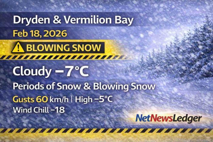
Dryden and Vermilion Bay are in a breezy, unsettled winter pattern this Wednesday, with periods of snow and blowing snow on the menu and a gusty east wind making it feel sharper than the thermometer suggests. The bigger picture is persistence: snow chances hang around through Thursday, then taper to flurries before a colder, clearer drop arrives by the weekend.
Current Conditions
At 8:00 AM CST, conditions are cloudy with:
-
Temperature: -7.0°C
-
Wind: ENE 22 km/h, gusting 45 km/h
-
Wind Chill: -14
-
Pressure: 100.4 kPa
-
Humidity: 57%
-
Visibility: 16 km
Even with only moderate snowfall amounts expected, that wind is enough to kick up loose snow and reduce visibility in exposed areas.
Today (Wednesday)
Expect periods of snow and blowing snow. Total snowfall isn’t huge, but the wind will create drifting and variable visibility—especially on open highways and rural roads.
-
Snow amount: about 2 cm
-
Wind: east 40 km/h gusting to 60
-
High: -5°C
-
Wind chill: -18 this morning, improving to -12 this afternoon
Tonight and Tomorrow
Tonight (Wednesday night)
Skies remain cloudy with a 60% chance of snow.
-
Wind: east 20 km/h gusting to 40
-
Low: -9°C
-
Wind chill: near -16
Thursday, February 19
Cloudy again with a 60% chance of snow, and winds easing as the day goes on.
-
Wind: east 20 km/h gusting to 40, becoming light in the morning
-
High: -5°C
-
Wind chill: -17 in the morning, around -11 in the afternoon
-
UV index: 1 (low)
Thursday night: Cloudy with a 60% chance of flurries, low -10°C.
Looking Ahead
Friday: Cloudy with a 60% chance of flurries, high -5°C.
Friday night: 40% chance of flurries, low -14°C.
Weekend trend: flurry chances continue, then a colder punch follows—clear Sunday night near -26°C, and sunny Monday near -10°C.
Wardrobe Recommendations
Today is all about blocking the wind:
-
Wear an insulated jacket with a wind-resistant shell.
-
Mitts and a warm hat are essential with wind chills in the mid-to-high teens below zero.
-
If you’re out on the highways, keep an extra layer and face covering handy—blowing snow can sting and chill quickly.
Driver tip: keep washer fluid topped up and the snow brush in reach. In blowing snow, your windshield and lights can get coated quickly.
Weather Trivia
Blowing snow can be deceptive: you don’t need heavy snowfall rates to get poor visibility. Strong winds lift snow already on the ground and recycle it through the air—creating sudden “white curtain” moments on open roads.
Summary
Dryden and Vermilion Bay weather for Wednesday, February 18, 2026: cloudy with periods of snow and blowing snow, gusty east winds up to 60 km/h, and a high near -5°C. Snow chances continue tonight and Thursday, then flurries taper off before a colder drop by Sunday night.


