
Weather Alerts and Warnings Across Canada
THUNDER BAY – WEATHER – The Arctic Low continues to grip Northwestern Ontario in its icy grasp. The Extreme Cold Warning for the region is continued. For Thunder Bay while there is little chance we will see polar bears walking the city streets, it is certainly cold enough they would feel welcome.
This morning, at 05:00 Northern Ontario can boast hosting the coldest spot in Canada with the mercury disappearing into the bottom of the thermometer in Peawanuck at a very chilly -46.4 °C.
For Thunder Bay, Environment Canada is calling for sunny skies becoming a mix of sun and cloud near noon. Winds of up to 15 km/h. The daytime high minus 28°C with the wind chill making it feel like minus 43°C in the morning and minus 38°C in the afternoon.
Remember, make sure your pets are not let outside for very long.
For Peawanuck, Sunday will see clear skies with winds of up to 15 km/h. The daytime high minus 36°C. The wind chill will make it feel like minus 56°C in the morning and minus 46°C in the afternoon.
Hot spot in Ontario: -0.7 °C 30.7 °F Long Point
Cold spot in Ontario: -46.4 °C -51.5 °F Peawanuck
Hot spot in Canada: 10.5 °C 50.9 °F Warner, AB
Cold spot in Canada: -46.4 °C -51.5 °F Peawanuck, ON
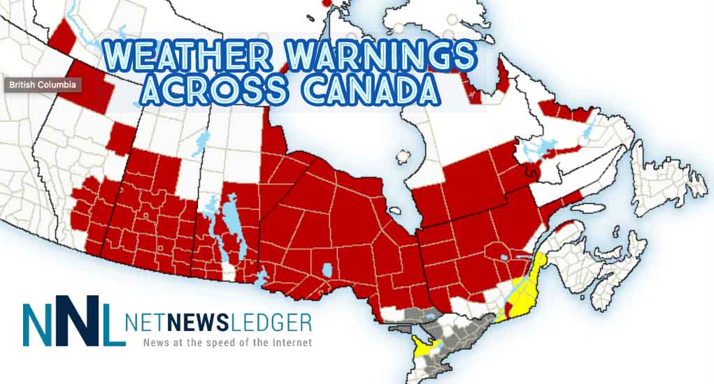
There are weather warnings and alerts out across Canada this morning.
While the hot spot in Canada is Warner, Alberta, there are wind warnings in effect for the southeastern part of that province.
Environment Canada warns that strong winds that may cause damage are expected or occurring. These winds are preceding the Alberta Clipper that is headed into Saskatchewan.
For southeastern Alberta a cold front associated with an approaching low-pressure system will sweep southward through the province on Sunday, bringing strong and gusty northerly winds. Wind gusts to 90 km/h are forecast starting in central regions in the morning and spreading southeastward through the afternoon. Some areas from Coronation to the Cypress Hills may see winds gusts up to 100 km/h.
Additionally, snow flurries will accompany the front as it moves southward producing reduced visibilities in falling snow. Behind the cold front, temperatures will drop quickly in the afternoon and evening.
For Saskatchewan, there is a freezing rain warning for Saskatoon along with wind warnings, snowfall warnings, and winter storm warnings.
In Manitoba, there is a mix of Extreme Cold Warnings and Snowfall warnings.
If you are planning travel the weather as you head west is likely to impact your plans.
Check with 511 for the latest road condition updates.
#Incident #ThunderBay #HWY102 WB entrance to Old Hwy South – lane blocked due to a disabled vehicle. #ONHwys Please use caution in the area.
— 511ONNorthwestern (@511ONNorthwest) January 27, 2019
Extreme Cold Warning in effect for:
- Pickle Lake – Cat Lake
- Savant Lake – Sturgeon Lake
- Sioux Lookout – Eastern Lac Seul
- Summer Beaver – Wunnummin Lake – Kingfisher Lake
- Kenora
- Dryden – Vermilion Bay
- Fort Frances
- Nigigoonsiminikaaning First Nation
- Seine River First Nation
- Ignace
- Attawapiskat
- Fort Severn
- Peawanuck
- Webequie
- Landsdowne House
- Kasabonika First Nation
- Summer Beaver
- Marten Falls – Ogoki
- Aroland
- Nipigon – Marathon – Red Rock First Nation
The multi-day episode of very cold wind chills continues.
Extreme wind chills of minus 40 to minus 50 are expected across much of Northern Ontario again tonight.
This arctic air mass will remain entrenched over the region through the weekend and into early next week, bringing a prolonged period of extremely cold wind chills.


