Arctic Glacier Ice Ponds Captured by NASA

556
Engineers installed a new camera system on MABEL for its summer 2014 campaign, so scientists could better understand what it measured during flights. A key goal of the Alaska-based campaign was to measure glacial melt ponds like this one, photographed July 16. Image NASA

Engineers installed a new camera system on MABEL for its summer 2014 campaign, so scientists could better understand what it measured during flights. A key goal of the Alaska-based campaign was to measure glacial melt ponds like this one, photographed July 16. Image NASA

HOUSTON – ENVIRONMENT – NASA has captured images of Arctic Glacier Ice Ponds. Even from 65,000 feet above Earth, the aquamarine melt ponds in the Arctic stand out against the white sea ice and ice sheets. These ponds form every summer, as snow that built up on the ice melts, creating crystal clear pools.

Some of these first images downloaded were just what the MABEL team wanted to see, said Thorsten Markus, ICESat-2 project scientist at NASA’s Goddard Space Flight Center in Greenbelt, Maryland. They want to understand how the MABEL data collected over a melt pond differs from data collected over open water, ice and more, and the images indicate there will be good measurements to analyze.
“We have clear open water, then we see melt ponds and then we see open water again,” Markus said of a shot taken on the way to the North Pole. “For algorithm development, this is perfect.”On July 16 and July 17, NASA’s ER-2 aircraft flew above Alaskan glaciers and to the North Pole, carrying an instrument called the Multiple Altimeter Beam Experimental Lidar, or MABEL. MABEL is a laser altimeter, measuring the elevation of glaciers, mountains, forests and other topography below. Scientists will use those measurements to design analysis software, or algorithms, for the upcoming Ice, Cloud and land Elevation Satellite-2 mission.

On a July 17 flight to the North Pole and back, the ER-2 aircraft carrying the MABEL instrument flew over fractured sea ice, dotted with melt ponds and marked by ridges formed by the dynamic ice. Image NASA

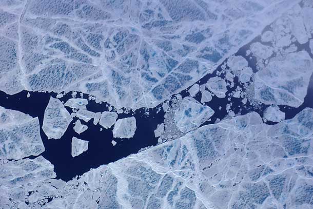
The 2014 MABEL campaign continued through July and was launched, in part, to capture melt ponds and other features of summer ice. After nine science flights out of Fairbanks, Alaska, the ER-2 and MABEL returned to California on Aug. 1, gathering additional data along the way. For this campaign, engineers added a new camera system to allow the team to match the MABEL measurements with a visual glimpse of the ground. The digital camera takes a picture every 3 seconds, each frame capturing an area about 2.5 by 1.5 kilometers (1.6 by 0.9 miles).

    Previous articleNew York City Man in Mount Sinai Hospital with Possible Ebola Virus
    Next articleMajor Police Presence in Downtown Fort William – August 4 2014
    NetNewsledger.com or NNL offers news, information, opinions and positive ideas for Thunder Bay, Ontario, Northwestern Ontario and the world. NNL covers a large region of Ontario, but are also widely read around the country and the world. To reach us by email: newsroom@netnewsledger.com Reach the Newsroom: (807) 355-1862