Hurricane Arthur begins to weaken as it pulls away from North Carolina
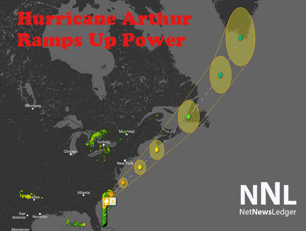
THUNDER BAY – WEATHER – Hurricane Arthur landed some punches in North Carolina, but the storm weakened while it was over land. The storm is now back over the Atlantic Ocean, and heading on a northerly track. The storm will be over New England by later today.
![]()
Summary of 900 am EDT…1300 UTC…information
———————————————-
location…37.1n 74.0w
about 130 mi…205 km E of Norfolk Virginia
maximum sustained winds…90 mph…150 km/h
present movement…NE or 40 degrees at 23 mph…37 km/h minimum central pressure…976 mb…28.82 inches
Watches and warnings
Changes with this advisory…
Environment Canada has issued a Tropical Storm Warning for Nova Scotia from Digby to Porters Lake.
Summary of watches and warnings in effect…
A Hurricane Warning is in effect for…
* Ocracoke Inlet North Carolina to the North Carolina/Virginia
border
* eastern Albemarle Sound
A Tropical Storm Warning is in effect for…
* the North Carolina/Virginia border to Cape Charles Light Virginia…including the mouth of the Chesapeake Bay
* western Albemarle Sound
* Nantucket
* Cape Cod from Provincetown to Woods Hole
* Digby to Porters Lake Nova Scotia
A tropical storm watch is in effect for…
* New Brunswick from the U. S./Canada border to grand-Anse
* Nova Scotia north of Digby…north of Porters Lake…and including Cape Breton island
* all of Prince Edward Island
A Tropical Storm Warning means that tropical storm conditions are expected somewhere within the warning area.
A tropical storm watch means that tropical storm conditions are possible within the watch area.
Interests elsewhere in coastal portions of New England…New Brunswick…and Newfoundland should monitor the progress of Arthur.
For storm information specific to your area in the United States…including possible inland watches and warnings…please monitor products issued by your local National Weather Service forecast office. For storm information specific to your area outside the United States…please monitor products issued by your National meteorological service.
Discussion and 48-hour outlook
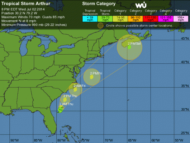
At 900 am EDT…1300 UTC…the eye of Hurricane Arthur was located by NOAA Doppler radar near latitude 37.1 north…longitude 74.0 west. Arthur is moving toward the northeast near 23 mph…37 km/h…and this motion is expected to continue with an increase in forward speed during the next couple of days. On the forecast track…the center of Arthur will move well offshore of the mid-Atlantic coast of the United States today…pass southeast of New England tonight…and be near or over western Nova Scotia early Saturday.
Maximum sustained winds are near 90 mph…150 km/h…with higher gusts. Some additional weakening is forecast during the next 48 hours…and Arthur is expected to become a Post-tropical cyclone tonight or Saturday.
Hurricane force winds extend outward up to 40 miles…65 km…from the center…and tropical storm force winds extend outward up to 125 miles…205 km.
The estimated minimum central pressure based on data from an Air Force hurricane hunter aircraft is 976 mb…28.82 inches.
Hazards affecting land
Wind…tropical storm conditions will continue in portions of the warning areas in North Carolina and Virginia this morning. Tropical storm conditions are expected to reach the warning area in New England by tonight.
Storm surge…the combination of a dangerous storm surge and the tide will cause normally dry areas near the coast to be flooded by rising waters. The water could reach the following heights above ground if the peak surge occurs at the time of high tide… North Carolina within the Hurricane Warning area…3 to 5 ft Pamlico and Albemarle sounds…2 to 4 ft extreme southeastern Virginia…1 to 3 ft Coastal flooding is also possible along Cape Cod.
The highest water will occur along the immediate coast in areas of onshore flow. The surge will be accompanied by large and damaging waves. Surge-related flooding depends on the relative timing of the surge and the tidal cycle…and can vary greatly over short distances. For information specific to your area…please see products issued by your local National Weather Service office and the new experimental potential storm surge flooding map for more details.
Rainfall…rainfall will be diminishing over eastern North Carolina this morning with storm total accumulations of 4 to 6 inches and isolated maximum of 8 inches possible. Rainfall totals of 1 to 2 inches are possible over southeastern Virginia. Rainfall accumulations of 2 to 4 inches are possible across Rhode Island…eastern Massachusetts and coastal Maine.
Surf…swells generated by Arthur are affecting areas along the coast of North Carolina…and will spread northward along the mid-Atlantic and northeast coasts of the United States today. These swells are expected to cause life-threatening surf and rip currents.
For more information…please monitor products issued by your local National Weather Service forecast office.
Next advisory
————-
next complete advisory…1100 am EDT.
$$
Forecaster Brown/Franklin


