
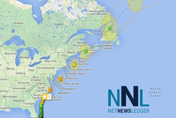
 THUNDER BAY – WEATHER – The eye of Hurricane Arthur is approaching the coastline of North Carolina. The storm has continued to increase in strength and is expected to be a full Category 2 Hurricane when it is near the coast of North Carolina.
Hurricane Arthur gained strength in the Atlantic on Thursday and threatened to strike near the North Carolina coast on Independence Day, prompting thousands of people to leave parts of the state’s popular but flood-prone Outer Banks. (July 3)
Copyright 2014 The Associated Press
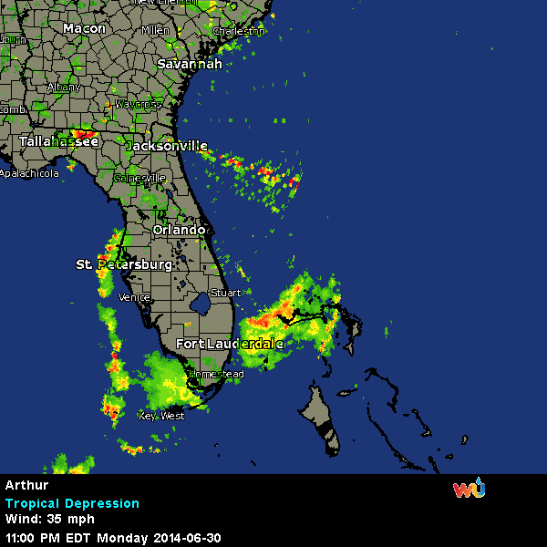
Here is the radar for the storm…
Summary of 500 PM EDT…2100 UTC…information
———————————————-
location…33.4n 77.9w
about 35 mi…55 km S of Cape Fear North Carolina
about 185 mi…300 km SW of Cape Hatteras North Carolina
maximum sustained winds…90 mph…150 km/h
present movement…NNE or 20 degrees at 13 mph…20 km/h
minimum central pressure…979 mb…28.91 inches
Watches and warnings
——————–
changes with this advisory…
A Tropical Storm Warning has been issued for Nantucket Island and for Cape Cod from Provincetown to Chatham.
Environment Canada has issued a tropical storm watch for Nova Scotia from port Maitland eastward and northward to Point Aconi.
Summary of watches and warnings in effect…
A Hurricane Warning is in effect for…
* Surf City North Carolina to the North Carolina/Virginia border
* Pamlico Sound
* eastern Albemarle Sound
A Hurricane Watch is in effect for…
* Little River Inlet to south of Surf City
A Tropical Storm Warning is in effect for…
* South Santee River South Carolina to south of Surf City
* the North Carolina/Virginia border to Cape Charles Light
Virginia…including the mouth of the Chesapeake Bay
* western Albemarle Sound
* Nantucket
* Cape Cod from Provincetown to Chatham
A tropical storm watch is in effect for…
* Nova Scotia from port Maitland to Point Aconi
A Hurricane Warning means that hurricane conditions are expected somewhere within the warning area. Preparations to protect life and property should have already been completed.
A Hurricane Watch means that hurricane conditions are possible within the watch area. Any unexpected deviation of the track to the left…or an expansion of hurricane-force winds into the northwest quadrant of the storm…would bring hurricane-force winds to the coast in the watch area.
A Tropical Storm Warning means that tropical storm conditions are expected somewhere within the warning area.
Interests elsewhere in coastal portions of New England…Nova Scotia…and Newfoundland should monitor the progress of Arthur. For storm information specific to your area in the United States…including possible inland watches and warnings…please monitor products issued by your local National Weather Service forecast office. For storm information specific to your area outside the United States…please monitor products issued by your National meteorological service.
Discussion and 48-hour outlook
at 500 PM EDT…2100 UTC…the center of Hurricane Arthur was located near latitude 33.4 north…longitude 77.9 west. Arthur is moving toward the north-northeast near 13 mph…20 km/h. A turn toward the northeast with an increase in forward speed is expected tonight…followed by a further increase in forward speed on Friday.
On the forecast track…the core of Arthur is expected to pass near or over the coast of North Carolina and the Outer Banks tonight.
The center of Arthur is forecast to pass east of the mid-Atantic coast Friday and approach Nova Scotia Friday night.
Data from an Air Force Reserve hurricane hunter aircraft indicate that maximum sustained winds are near 90 mph…150 km/h…with higher gusts. Some strengthening is forecast during the next 24 hours…and Arthur is expected to be a category two hurricane when it passes over or near the North Carolina coast. Arthur is expected to begin weaken Friday night and is forecast to become a Post-tropical cylone Saturday.
Hurricane force winds extend outward up to 35 miles…55 km…from the center…and tropical storm force winds extend outward up to 150 miles…240 km.
The latest minimum central pressure measured by an Air Force Reserve reconnaissance aircraft was 977 mb…28.85 inches.
Hazards affecting land
Wind…tropical storm conditions are expected to reach portions of the warning area within the next few hours and spread northward through the tropical storm and Hurricane Warning areas this evening and tonight. Hurricane conditions are expected within portions of the Hurricane Warning area by tonight. Hurricane-force winds are possible in the Hurricane Watch area beginning this evening. Any unexpected deviation of the track to the left…or an expansion of hurricane-force winds into the northwest quadrant of the storm…would bring hurricane-force winds to the coast in the Hurricane Watch area.
Storm surge…the combination of a dangerous storm surge and the tide will cause normally dry areas near the coast to be flooded by rising waters. The water could reach the following heights above ground if the peak surge occurs at the time of high tide… North Carolina within the Hurricane Warning area…3 to 5 ft Pamlico and Albemarle sounds…2 to 4 ft southern North Carolina and northeastern South Carolina…1 to 3 ft extreme southeastern Virginia…1 to 3 ft The highest water will occur along the immediate coast in areas of onshore flow. The surge will be accompanied by large and damaging waves. Surge-related flooding depends on the relative timing of the surge and the tidal cycle…and can vary greatly over short
distances. For information specific to your area…please see products issued by your local National Weather Service office and the new experimental potential storm surge flooding map for more details.
Rainfall…rainfall accumulations of 4 to 6 inches…with isolated maximum amounts of 8 inches…are expected over coastal areas of North Carolina through Friday. Rainfall accumulations of 1 to 2 inches are possible along the upper coast of South Carolina.
Rainfall accumulations of 2 to 4 inches are expected over portions of eastern Massachusetts and Rhode Island.
Tornadoes…isolated tornadoes are possible over portions of coastal North Carolina through Friday morning.
Surf…swells generated by Arthur are affecting areas from the coast of Georgia northward to North Carolina. These swells are expected to cause life-threatening surf and rip currents. For more information…please monitor products issued by your local National Weather Service forecast office.
Next advisory
next intermediate advisories…700 PM EDT and 900 PM EDT.
Next complete advisory…1100 PM EDT.
$$
Forecaster Brown


