Northeast Ontario Wildfire Update: 20 New Fires Confirmed, 61 Active
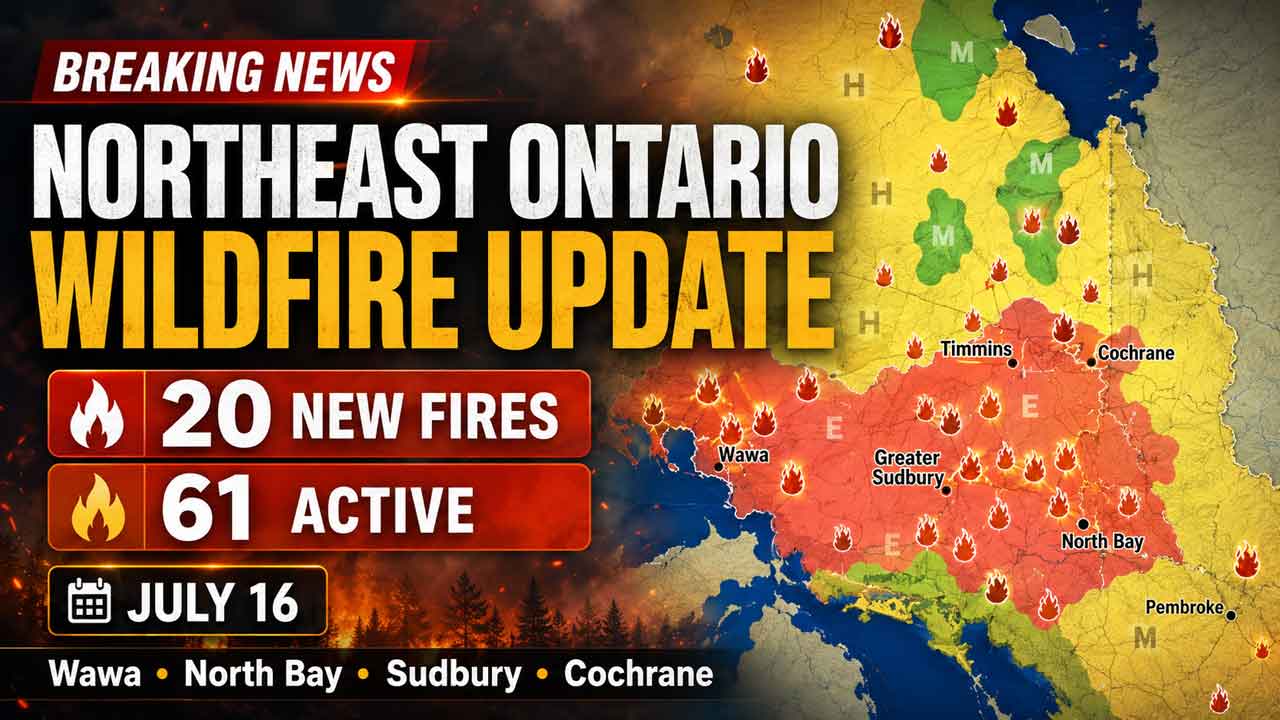
WAWA — Twenty new wildland fires were confirmed across Ontario’s Northeast Fire Region on July 16, bringing the regional total to 61 active fires.
Most of the new fires remained small at the time of the evening update, but several were not under control, including incidents near Highway 17, Lake Superior Provincial Park and communities in the North Bay, Sudbury, Wawa, Timmins and Cochrane fire districts.
The fire activity is important for Northwestern Ontario residents and travellers because Wawa and the Highway 17 corridor form a key transportation link between Thunder Bay, Sault Ste. Marie and southern Ontario. Smoke, suppression operations or changing fire conditions could affect road travel, tourism, aviation and access to remote areas.
Twenty New Fires Confirmed on July 16
Aviation, Forest Fire and Emergency Services reported the following new wildland fires:
North Bay Fire District
North Bay 27 is a 10-hectare fire located about two kilometres south of Hand Lake. The fire is not under control.
North Bay 28 is a 0.1-hectare fire on the western shore of Eaglerock Lake. It is not under control.
North Bay 29 is a 0.8-hectare fire located three kilometres north of Lake Nipissing, near Laronde Creek. It is not under control.
North Bay 30 is a 0.1-hectare fire on the western shore of Plum Lake. It is not under control.
North Bay 31 is a 0.7-hectare fire north of Scarecrow Lake. It is not under control.
North Bay 32 is a 0.1-hectare fire located two kilometres north of McFarlane Lake. It is not under control.
North Bay 33 is a 0.1-hectare fire on the northeast shore of Azen Lake. It is not under control.
Cochrane Fire District
Cochrane 43 is 21 hectares and is being observed. It is located approximately 38 kilometres west of Fort Albany.
Cochrane 44 is 117 hectares and is being observed. It is located south of the confluence of the Chard and Tchakashapug rivers.
Cochrane 42 was confirmed after the previous evening’s update. The one-hectare fire is being held and is located approximately three kilometres southeast of the Fox River and eight kilometres north of Bannerman Lake.
A fire classified as being held is not expected to spread beyond its current boundaries under prevailing and forecast conditions if suppression efforts continue.
Wawa Fire District
Wawa 21 is a 0.1-hectare fire located approximately 13 kilometres south of Highway 11 on the Mistake River. It is not under control.
Wawa 22 is a 0.7-hectare fire located one kilometre south of Taradale Lake. It is not under control.
Wawa 23 is a 1.5-hectare fire located approximately two kilometres southeast of Vein Lake. It is not under control.
Wawa 24 is a 0.1-hectare fire near the Baldhead River in Lake Superior Provincial Park. It is not under control.
The fire in Lake Superior Provincial Park may be of particular interest to travellers from Thunder Bay and Northwestern Ontario. The park is located along Highway 17 and is a major destination and travel corridor between Wawa and Sault Ste. Marie.
Visitors should monitor provincial park notices and official highway information before travelling through the area.
Sudbury Fire District
Sudbury 22 is a 0.5-hectare fire located one kilometre west of Maskinonge Lake. The fire is being held.
Sudbury 23 is a 0.1-hectare fire on the east shore of Knight Lake. It is not under control.
Sudbury 24 is a 0.8-hectare fire located one kilometre east of Millerd Lake. It is not under control.
Sudbury 25 is a 0.4-hectare fire located one kilometre west of Wavy Lake. It is not under control.
Sudbury 26 is a 1.5-hectare fire located one kilometre south of Highway 17, west of Massey. It is not under control.
The location of Sudbury 26 near Highway 17 is significant because the highway is the primary east-west route across Northern Ontario. Fire conditions near the corridor can affect passenger travel, commercial trucking and the movement of supplies between communities.
Timmins and Chapleau Fire Districts
Timmins 23 is a 0.5-hectare fire located approximately one kilometre east of Kapiskong Lake. It is not under control.
Chapleau 13 is a 0.3-hectare fire located three kilometres southwest of Belford Creek. It is not under control.
Regional Total Reaches 61 Active Fires
There were 61 active wildland fires in the Northeast Fire Region as of the 7:30 p.m. update.
Of those fires:
18 were not under control
Six were being held
Seven were under control
30 were being observed
A fire being observed is monitored to assess its behaviour, location and potential threat. Some remote fires may be allowed to burn when they are not threatening communities, infrastructure or other identified values.
Regional Implications for Northern Ontario
Although the fires are in the Northeast Fire Region, several incidents are close to transportation routes and recreation areas used by people travelling from Thunder Bay and Northwestern Ontario.
Highway 17 is the main overland connection between Thunder Bay, Wawa, Sault Ste. Marie, Sudbury and communities farther east. Fire-related road closures or heavy smoke can create long delays because there are few practical alternate routes.
The fires may also affect forestry operations, mining exploration, tourism businesses, remote lodges and access to traditional lands.
Northern and remote First Nations can face additional challenges during periods of elevated fire activity because evacuations may require aircraft and emergency accommodations far from home communities.
Stay Clear of Waterbombers
Ontario is reminding boaters to remain clear of waterbombers operating on lakes and rivers.
When a waterbomber approaches, boat operators should move close to shore and remain out of the aircraft’s path.
A waterbomber will not scoop water when boats or other watercraft create a safety hazard. Delays can affect suppression operations and increase risks for firefighters and nearby communities.
Boaters should never attempt to approach or follow firefighting aircraft.
Outdoor Burning Rules Remain in Effect
Ontario’s legislated fire season runs from April 1 to Oct. 31.
During this period, provincial outdoor burning rules apply in areas where municipal regulations do not take precedence.
The province encourages residents to use alternatives to burning yard waste and woody debris, including composting or using a local landfill.
Where burning is permitted, fires may be ignited no earlier than two hours before sunset and must be extinguished no later than two hours after sunrise.
Anyone conducting an outdoor burn must have enough water and appropriate tools available to control and fully extinguish the fire.
Residents within municipal boundaries must also check with their local fire department for permit requirements, fire bans or additional restrictions.
Even a small escaped fire can draw crews and aircraft away from larger incidents.
Report a Wildland Fire
To report a wildland fire north of the French and Mattawa rivers, call 310-FIRE, or 310-3473.
To report a wildland fire south of the French or Mattawa rivers, call 911.
Current fire information, prevention guidance and regional updates are available through Ontario’s official forest fire information service and the province’s @ONforestfires and @ONfeudeforet social media accounts.