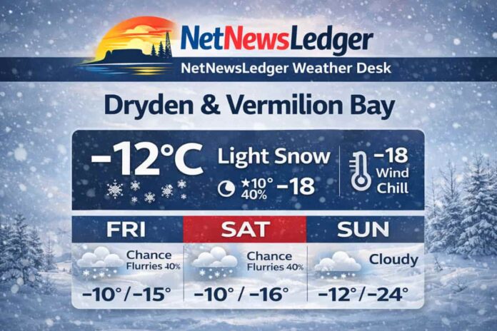
DRYDEN – WEATHER – Dryden and Vermilion Bay are starting Friday with light snow and a sharp wind chill, setting up a weekend that stays mostly cloudy with occasional flurries. The bigger headline is the cold: overnight lows drop into the mid-to-upper teens below zero, with a deep freeze near -24°C by Sunday night.
Current Conditions (6:23 AM CST, Friday, February 20)
-
Temperature: -12.4°C
-
Condition: Light Snow
-
Wind: NE 11 km/h
-
Wind Chill: -18
-
Humidity: 85% (Dew point: -14.4°C)
-
Pressure: 101.0 kPa
-
Visibility: 8 km
Light snow and reduced visibility can make roads look “fine” while still hiding slick patches—especially on bridges, hills, and untreated side roads.
Expected Conditions (Next Three Days)
Friday (Today)
-
Periods of light snow ending this morning, then cloudy with a 40% chance of flurries
-
Wind: Up to 15 km/h
-
High: -10°C
-
Wind chill: -18 this morning, improving to near -13 this afternoon
-
UV index: 1 (Low)
Friday Night
-
Cloudy with a 40% chance of flurries
-
Wind: Up to 15 km/h
-
Low: -15°C
-
Wind chill: Near -20 overnight
Saturday (Feb 21)
-
Cloudy with a 40% chance of flurries
-
Wind: Up to 15 km/h
-
High: -10°C
-
Wind chill: Near -21 in the morning, around -15 in the afternoon
-
Saturday Night: Cloudy, low -16°C
Sunday (Feb 22)
-
Cloudy
-
High: -12°C
-
Sunday Night: Cloudy periods, low -24°C
Early next week: A mix of sun and cloud returns Monday, but flurries remain possible at times.
Wardrobe Recommendations
This weekend is all about staying warm in persistent cloud and occasional flurries:
-
Base layer: Thermal top (and long underwear if you’ll be outdoors for long)
-
Mid layer: Fleece or wool for insulation
-
Outer layer: Wind-resistant winter coat (cloudy + breeze keeps it feeling colder)
-
Hands/Head/Neck: Mitts, toque, and a neck warmer—wind chill is the main discomfort
-
Boots: Insulated boots with good tread; carry traction aids if you’re walking on packed snow/ice
-
Sunday night: Dress for deep cold—exposed skin cools quickly when temperatures dip into the -20s.
Weather Trivia
Cold, cloudy weekends can still produce sudden temperature drops at night. If skies partially clear even briefly, heat escapes quickly from snow-covered ground, leading to rapid “radiational cooling”—one reason lows can plunge even when daytime weather seems steady.
Summary
Dryden and Vermilion Bay weekend weather forecast for Feb 20–22, 2026: light snow ending Friday morning, then mostly cloudy with a 40% chance of flurries, highs near -10 to -12°C, and a sharp drop to -24°C Sunday night.


