Dryden – WEATHER DESK – A deep mid-winter cold is still in control across Northwestern Ontario this morning, with very low temperatures and biting wind chills. The next change is on the way: flurries return tonight, then a more organized snow event arrives Wednesday night into Thursday, followed by a colder, quieter Friday.
Today’s Weather Overview
Current Conditions
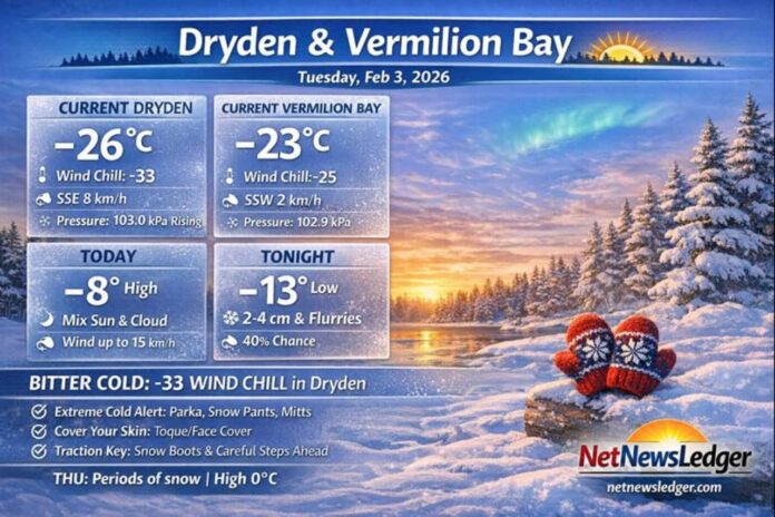
Dryden (Observed at Dryden Airport — 7:00 AM CST):
Mainly clear and extremely cold at -26.1°C, with a wind chill of -33. Winds are S 8 km/h, humidity 79%, and pressure 103.0 kPa. Visibility is 16 km.
Vermilion Bay (Observed at Rawson Lake — 7:00 AM CST):
Temperature is -23.1°C with a wind chill of -25. Winds are light at SSW 2 km/h, humidity 80%, and pressure 102.9 kPa and rising. (The station lists the condition as “not observed,” but the readings are available.)
Today (Tuesday):
For both communities, expect a mix of sun and cloud, wind up to 15 km/h, and a daytime high near -8°C. Wind chill values ease from about -21 this morning to around -13 this afternoon.
Extended Weather Forecast
Wednesday, Feb 4
Mainly cloudy with a 40% chance of morning flurries, wind up to 15 km/h, and a high near -11°C. Wind chills sit near -21 in the morning and -14 in the afternoon. Wednesday night: periods of snow, low near -13°C.
Thursday, Feb 5
Periods of snow with a notable warm-up to 0°C. Thursday night: cloudy with a 30% chance of flurries, low near -21°C.
Friday, Feb 6
A mix of sun and cloud, high near -14°C. Friday night: cloudy periods, low near -24°C.
Wardrobe Recommendations
-
This morning (especially Dryden): Dress like it’s serious—because it is. With wind chills near -33 in Dryden, any exposed skin gets uncomfortable fast. Go with a winter parka, insulated boots, snow pants for longer outdoor time, and a warm base layer.
-
Cover the gaps: Mitts over gloves, a toque, and a neck warmer/balaclava are the difference between “fine” and “miserable.”
-
Tonight into Thursday: Keep traction in mind. Flurries tonight and periods of snow Wednesday night/Thursdaycan mean slick roads, parking lots, and sidewalks.
-
Thursday’s warm-up (near 0°C): Snow can get heavier and more compact. Waterproof outer layers help if things trend slushy.
Weather Trivia
For early February, both locations list climate normals around -10°C for the daytime high and -21°C for the overnight low—so today’s daytime forecast near -8°C is slightly milder than normal, even though the morning started brutally cold.
Summary
NetNewsLedger Weather Desk forecast for Dryden and Vermilion Bay (Feb 3, 2026): bitter cold this morning with wind chills as low as -33 in Dryden, mix of sun and cloud today, flurries tonight, then periods of snow Wednesday night into Thursday with a high near 0°C.

