ORANGE WINTER STORM WARNING: WHAT IT MEANS FOR GERALDTON & GREENSTONE
THUNDER BAY – WEATHER DESK – Got two pairs of “Mittens for your Kittens”? Put them on ’em!
Today is winter in Northern Ontario Day in Geraldton and Greenstone.
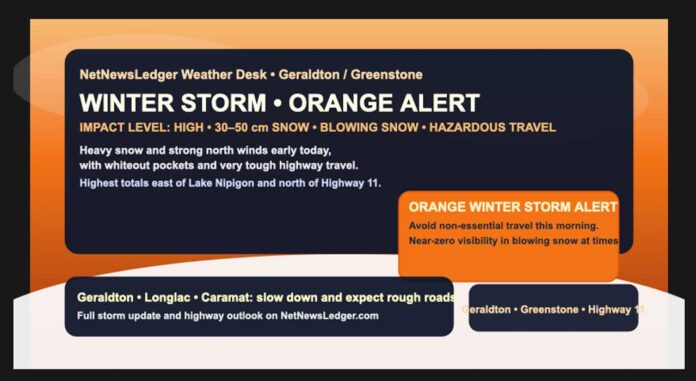
The worst of the winter storm is starting to ease across Geraldton, Longlac and Caramat, but conditions are still very challenging early this Friday morning. Snow, blowing snow and bitter wind chills are keeping the ORANGE Winter Storm Warning in effect, with high impact and high confidence from Environment Canada.
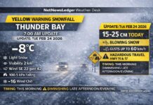
As of 6:29 a.m. EST at Geraldton Airport, it’s a classic “stay bundled” morning. Light snow is still falling with visibility down to about four kilometres. The temperature sits near -21°C, feeling more like -33°C in the north-northwest winds of 24 km/h, gusting to 46 km/h. Humidity is at 75%, and the pressure has nudged up to 100.5 kPa, a sign the system is slowly shifting, but not done with you yet.
What the ORANGE Winter Storm Alert Means
The ORANGE warning in Environment Canada’s colour-based impact system is a step above a Yellow advisory or watch. In simple terms, Orange means:
This isn’t just “messy weather” — it’s hazardous and disruptive.
For Geraldton and Greenstone, the Orange Winter Storm warning reflects:
-
Total snowfall of 30 to 50 centimetres, with locally higher amounts east of Lake Nipigon and north of Highway 11.
-
Strong northerly winds, gusting 50 to 60 km/h, at times higher south of Lake Nipigon.
-
Blowing snow and near-zero visibility in open areas.
-
Risk of road closures, stranded vehicles, and disruptions to transportation, services and utilities.
In effect, Orange is the “avoid non-essential travel” tier. You’re encouraged to stay off the roads unless you truly need to be out, and be ready for interruptions in normal routines. Yellow is “be careful,” Orange is “this will significantly affect you.”
Friday Morning: Storm Ending, Blowing Snow and Dangerous Wind Chills
Early this morning, snow and local blowing snow continue, but the heaviest bands have shifted east of the region. Another up to 5 centimetres of snow is possible before the system finally loosens its grip later in the morning.
Northerly winds near 30 km/h, gusting to 50 km/h are still pushing snow around, which means:
-
Periods of poor visibility, especially in open and rural areas.
-
Snowpacked and drifted roads, laneways and sidewalks.
-
Ongoing risk of road closures or travel delays.
Temperatures are not doing you any favours either. The high today will struggle to reach -17°C, and with those north winds, wind chill values near -35 this morning and around -21 this afternoon will make it feel dangerously cold. At these levels, frostbite can develop in minutes on exposed skin.
The forecast for today calls for the snow and blowing snow to end this morning, followed by clearing skies into the afternoon as winds gradually ease and shift. Conditions will improve from west to east as the day goes on, but roads and walkways will stay snowy, icy and rough.
Tonight and Saturday: More Snow on the Way
Just because the main winter storm is backing off doesn’t mean the snow is finished.
Tonight, skies cloud over again and another band of snow moves in overnight, bringing 2 to 4 centimetres. Winds diminish to light, but the cold digs in:
-
Low near -23°C, with the temperature actually rising to about -14°C by morning.
-
Wind chill around -31°C this evening, with continued frostbite risk.
On Saturday, expect snow again, with around 5 centimetres forecast. Winds turn northwest near 20 km/h late in the afternoon, and the high climbs to about -8°C. That may sound “warmer,” but wind chill values will still run near -23 in the morning and -15 in the afternoon. Saturday night, snow continues with a low near -21°C.
By Sunday, you finally get a break: a mix of sun and cloud with a 40 percent chance of flurries and a high near -15°C, followed by a clear, very cold night near -26°C.
Travel and Safety: Orange Means Rethink Your Plans
With snow totals pushing into the 30 to 50 centimetre range in parts of the region, this is not a “quick brush-off-the-car” event. For Geraldton, Longlac, Caramat and nearby communities:
Roads and sidewalks are likely:
-
Deeply snow covered and rutted
-
Slick underneath from compacted layers
-
Narrowed by plow banks and drifts
Even as snow ends and the sun appears, north winds and frigid air will keep blowing snow and black ice in play. If you can delay non-essential travel, today is a smart day to do so. If you must travel: slow down, allow extra stopping distance, and pack winter emergency supplies in your vehicle.
At home and around town, watch for heavy snow loads on roofs, sheds and carports, especially where drifting has piled snow unevenly.
What to Wear in Geraldton / Greenstone Today
This is full deep-winter survival mode clothing, not “dash out in a hoodie” weather. For heading outside:
Go with a heavy, insulated parka with a good hood to block those north winds. Base layers matter: a thermal top and leggings under your regular clothes will make a huge difference. Add insulated snow pants or lined pants if you’re shovelling, working outside or walking long distances.
On your feet, choose insulated winter boots with a good tread; sidewalks, driveways and parking lots will be a mix of snow, ice and packed slush. Hands and head need extra attention: insulated mitts or gloves, a warm toque, and ideally a neck gaiter or scarf to protect your face from wind and blowing snow.
This is the kind of morning where you’ll be glad you overdressed rather than tried to tough it out.
Geraldton / Greenstone Weather Trivia – Why the Snow Band Is So Intense Here
The Geraldton and Greenstone region often finds itself in a sweet (or not-so-sweet) spot for big winter storms. When a strong low tracks to the southeast and cold Arctic air pours in from the north, the landscape east of Lake Nipigon and north of Highway 11 can sit under a persistent band of heavier snow.
Subtle differences in wind direction, elevation and distance from the lake can make a big difference in totals — which is why Environment Canada is highlighting locally 50+ centimetre accumulations east of Lake Nipigon even as other areas see less. In other words, a shift of just a few tens of kilometres in storm track can decide whether you’re shovelling your driveway once… or three times.
The Last Word on the Weather: Geraldton–Greenstone faces an intense winter storm, with up to 50 cm of snow, blowing snow, -30s wind chills and an Orange Winter Storm alert through Friday morning.

