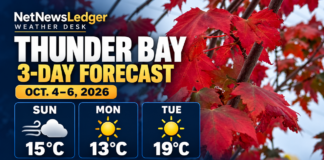
Northwestern Ontario faces gusty Sunday winds and showers before Monday sunshine and a warmer Tuesday. Pickle Lake may see wet flurries
THUNDER BAY – WEATHER DESK – Sunday, October 4, 2026 – Northwestern Ontario is in for a windy and changeable Sunday. Northwest winds will gust to 50 km/h in many communities, while scattered showers remain possible through the afternoon.
Conditions will improve quickly Monday, with sunshine across most western districts after overnight fog clears. Tuesday turns much warmer, with highs reaching 17 to 20 C in several communities.
Pickle Lake remains the colder exception, with showers Sunday and a chance of flurries or rain showers early Monday.
Weather Alerts
No Environment and Climate Change Canada weather alert was listed for Northwestern Ontario during the early Sunday morning check. Frost advisories were posted in parts of eastern Ontario, but not in the communities covered by this report.
Alerts can change quickly. Travellers, boaters and outdoor workers should check the official ECCC alert map before leaving.
Three-Day Forecast: October 4 to 6
| Community or Area | Sunday, October 4 | Monday, October 5 | Tuesday, October 6 |
|---|---|---|---|
| Kenora and Lake of the Woods | A mix of sun and cloud with a 30 per cent chance of afternoon showers. Northwest wind 30 km/h gusting to 50. High 14 C. A 30 per cent chance of early-evening showers, then clearing with overnight fog. Low 2 C. | Sunny after fog patches clear. High 15 C. Clear Monday night, with a low of 11 C. | Sunny and much warmer, with a high of 19 C. A 30 per cent chance of showers Tuesday night. |
| Dryden and Vermilion Bay | A mix of sun and cloud with a 30 per cent chance of afternoon showers. Northwest wind 30 km/h gusting to 50. High 13 C. Clearing near midnight with overnight fog. Low 0 C. | Sunny, becoming a mix of sun and cloud late in the morning. Fog clears during the morning. South wind 20 km/h develops late in the afternoon. High 13 C. Cloudy periods Monday night, with a low near 5 C. | A mix of sun and cloud with a 30 per cent chance of showers. High near 18 C. |
| Sioux Lookout and Savant Lake | Mainly cloudy with a 30 per cent chance of afternoon showers. Northwest wind 30 km/h gusting to 50. High 11 C. Clearing late tonight with fog patches and a low of -2 C. | Mainly sunny or sunny before some afternoon cloud develops. Fog clears during the morning. High 12 C, with an early wind chill near -5. Cloudy periods Monday night, with a low near 2 C. | Cloudy with a 40 per cent chance of showers. High near 17 C. |
| Red Lake and Ear Falls | Mainly cloudy with a 30 per cent chance of afternoon showers. Northwest wind 30 km/h gusting to 50. High 12 C. Clearing this evening with overnight fog. Low near 0 C. | A mix of sun and cloud after fog clears. High 12 C. Cloudy periods Monday night, with a low near 6 C. | A mix of sun and cloud with a 40 per cent chance of showers. High near 17 C. |
| Fort Frances, Emo and Rainy River | A mix of sun and cloud with a 30 per cent chance of afternoon showers. Northwest wind 30 km/h gusting to 50. High 15 C. Clearing this evening with overnight fog. Low 0 C. | Sunny after fog patches clear. High 16 C. Clear Monday night, with a low near 4 C. | A mix of sun and cloud with a 30 per cent chance of showers. High near 20 C. |
| Atikokan and Quetico | A mix of sun and cloud with a 40 per cent chance of showers. Northwest wind 30 km/h gusting to 50. High 14 C. Clearing late this evening with overnight fog. Low -1 C. | Sunny, becoming a mix of sun and cloud during the afternoon. Fog clears during the morning. High 16 C. Cloudy periods Monday night, with a low near 2 C. | A mix of sun and cloud with a 30 per cent chance of showers. High near 18 C. |
| Pickle Lake | Rain and drizzle end near noon, followed by showers and a risk of a late-afternoon thunderstorm. Northwest wind 30 km/h gusting to 50. High 9 C. A 40 per cent chance of rain showers or flurries before morning. Low 1 C. | Mainly cloudy with a 40 per cent chance of flurries or rain showers in the morning. High 8 C. Cloudy periods Monday night, with a low near 2 C. | Cloudy with a 40 per cent chance of showers. High near 15 C. |
| Ignace and English River | Mainly cloudy with a 30 per cent chance of showers. Northwest wind 30 km/h gusting to 50. High 13 C. Clearing near midnight with overnight fog. Low 0 C. | Sunny, becoming a mix of sun and cloud late in the morning. Fog clears during the morning. South wind 20 km/h develops late in the afternoon. High 13 C. | A mix of sun and cloud with a chance of showers. High in the upper teens. |
Colder and Wetter Toward Pickle Lake
Pickle Lake and communities farther north will remain colder than the southern districts. Sunday brings showers, gusty northwest winds and a risk of a thunderstorm around Pickle Lake. Rain showers may mix with flurries overnight and early Monday.
The flurry risk does not amount to a snowfall warning, and ECCC has not provided an accumulation forecast. However, wet surfaces could become locally slippery as temperatures approach freezing.
Other Communities Facing Significant Conditions
Armstrong, Auden and Wabakimi Park can expect cloudy skies, a 40 per cent chance of showers and northwest gusts to 50 km/h Sunday. Geraldton, Longlac and Caramat will remain cooler, with a high near 9 C after morning rain ends.
Communities farther north and east face stronger winds. Big Trout Lake and Kasabonika could see northwest gusts to 60 km/h. Webequie may receive rain with gusts reaching 70 km/h late Sunday afternoon. These areas should use the Far Northern Ontario forecast and local aviation information when planning travel.
Travel Outlook: Crosswinds, Wet Leaves and Monday Fog
Northwest gusts to 50 km/h may produce crosswinds on exposed sections of Highways 11, 17, 71, 105, 502 and 599. Drivers of transport trucks, campers and vehicles towing trailers should reduce speed and be prepared for sudden gusts.
Scattered showers may leave wet pavement Sunday. Wet leaves can reduce traction and hide standing water. Overnight fog may reduce visibility around Kenora, Dryden, Fort Frances, Atikokan, Red Lake, Ear Falls, Sioux Lookout and nearby rural roads early Monday.
Temperatures may fall to -2 C around Sioux Lookout and Savant Lake and -1 C near Atikokan and Quetico. Drivers should watch for isolated frost or slippery patches on bridges, wooden surfaces and untreated roads early Monday.
Boating and Outdoor Work
Northwest winds gusting to 50 km/h can make Lake of the Woods, Lac Seul, Rainy Lake, Wabigoon Lake and other large inland lakes choppy. Conditions on open water may be rougher than those seen from a sheltered dock or bay.
- Wear an approved personal flotation device and carry reliable communications.
- Check local observations before leaving shore and allow extra time to return.
- Small-craft operators should avoid exposed water when winds increase.
- Outdoor workers should secure signs, tarps, tools and lightweight equipment.
- Hunters and backcountry travellers should carry dry layers and prepare for near-freezing overnight temperatures.