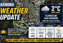
Kenora • Grassy Narrows • Lake of the Woods – Outlook for Wednesday, November 5, 2025
KENORA – A nippy, partly cloudy start greets the region with a classic November mix on the way. At 5:00 AM CST, the Kenora Airport reports 0.2°C and partly cloudy skies. The barometric pressure is 101.7 kPa and rising, a hint of temporary stability before the next system. Humidity sits at 79% with a dew point of –3.1°C.
A WNW breeze near 11 km/h is already in play, and visibility is 24 km—crisp enough to see across the bays.
Today trends mainly cloudy with a 30% chance of flurries or a few rain showers late this morning and through the afternoon. Winds become northwest 20 km/h, gusting to 40 by late morning, giving the air some bite as temperatures top out near +3°C. The UV index is 1 (low), so it’s all about warmth, not sunscreen, today.
Tonight – A Few Early Flurries, Then Colder and Calmer
This evening turns partly cloudy with a lingering 30% chance of flurries early. Winds ease from west 20 km/h to light early in the evening. Overnight lows dip to –3°C, and with lighter winds the wind chill near –6 will nip at exposed fingers and ears. Watch for slick patches on bridges and shaded spots by dawn.
Thursday – Messy Midday Mix, Then All Snow at Night
Thursday arrives cloudy, with periods of snow or rain beginning near noon. Expect about 2 cm of snow if the colder air wins; a rain–snow mix is more likely right at the start around town and along exposed shorelines. Winds are light (up to 15 km/h), but it will feel raw with a morning wind chill near –8 and an afternoon high around +2°C. Thursday night shifts to periods of snow and turns colder with a low near –5°C—plan on wintry driving surfaces by late evening into early Friday.
Friday – Bright Breaks, Flurry Chances, and Below-Freezing Highs
Friday features a mix of sun and cloud with a 40% chance of flurries and a decidedly wintry high near –2°C. Friday night brings increasing cloudiness and a deeper chill to –6°C. Sidewalks and steps may glaze early and late—salt and careful footing recommended.
What to Wear (and Pack)
Lean into layers: a thermal base, a warm mid-layer, and a wind-resistant shell for today’s northwest gusts. Add a toque and gloves—you’ll want them this morning and again tonight. Waterproof, grippy footwear will pay off for slushy/flurry windows Thursday and icy patches overnight. Keep the ice scraper handy for the next few mornings.
Around the Lake
Northwest winds will funnel between islands on Lake of the Woods, kicking up choppy pockets even when it looks calmer elsewhere. If you’re on the water, plan conservative routes and be mindful of wind shifts along exposed reaches and docks.
Lake of the Woods Trivia
With over 14,500 islands, Lake of the Woods can create mini wind tunnels and sheltered havens just a bay apart. On northwest flows like today, one cove can be riffled while the next is a whitecap factory—local knowledge is gold.


