Kenora • Grassy Narrows • Lake of the Woods – Forecast from Tuesday, November 4 to Friday, November 7, 2025
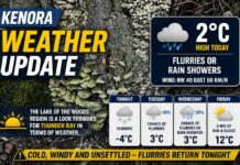
KENORA – A cool, mostly cloudy start gives way to a brief mild bump today before we stair-step down toward flurries and sub-zero highs by Friday. At 6:00 AM CST, the Kenora Airport reports 0.3°C under mostly cloudy skies. The pressure is 101.7 kPa (falling), humidity 66%, dew point –5.4°C, and a light WSW wind at 11 km/h. Visibility is 24 km—crisp and clear enough to see those last stubborn leaves braving the breeze.
Today – Cloud Builds, Mildest Day of the Week
Expect increasing cloudiness through the morning with a seasonably mild high near 9°C. The UV index is 1 (low). Winds remain on the lighter side compared to the weekend’s blow, so it’s a decent day for errands and a shoreline stroll—just carry a layer for the cool start.
Tonight: Skies clear this evening and temperatures slip to –1°C. With clearing and light winds, expect patchy frost by dawn on decks, docks, and windshields.
Wednesday – Back to November: Flurry/Showers Risk, Colder
A more wintry feel returns. Mainly cloudy with a 40% chance of flurries or rain showers, and winds becoming northwest 20 km/h in the morning. The high reaches only +3°C, and the morning wind chill near –7 will nip at fingers and ears.
Wednesday night: Clear and colder with a low near –2°C—icy patches possible by early Thursday.
Thursday – Mixed Mood, Late-Day Chill
Expect cloudy skies with a 30% chance of showers and a high near +4°C. As colder air sneaks in after dark, cloudy periods continue with a 60% chance of flurries and a low around –5°C—a reminder that winter’s just offstage.
Friday – Bright Bits with Flurry Flicks, Sub-Zero High
A mix of sun and cloud with a 30% chance of flurries and a wintry high near –2°C. Friday night turns colder under increasing cloudiness, low around –6°C. Roads stay mainly bare, but untreated sidewalks and steps can glaze early and late.
What to Wear (Wardrobe Forecast)
Lean on layers you can add or peel off: a warm base, fleece, and a wind-resistant shell. You’ll want hat and gloves Wednesday morning and again Thursday night onward. Waterproof, grippy footwear is smart for frosty mornings and the chance of flurries mid-week.
Barometer, Wind & Humidity – Why It Feels the Way It Does
Rising and then falling pressure around a passing disturbance explains today’s cloud increase followed by mid-week cooling. The northwest flow Wednesday taps colder air, knocking highs down and bringing that flurry risk. With humidity in the 60–70% range and near-freezing temps at night, expect frost on clear nights.
Lake of the Woods Trivia
With over 14,500 islands, Lake of the Woods can funnel and break the wind in surprising ways. That’s why one bay can be glassy while the next is a whitecap factory—local routes matter on breezy days!


