Intense Weather System to Affect Alberta, Saskatchewan, and Manitoba with Heavy Snowfall and Bitter Cold
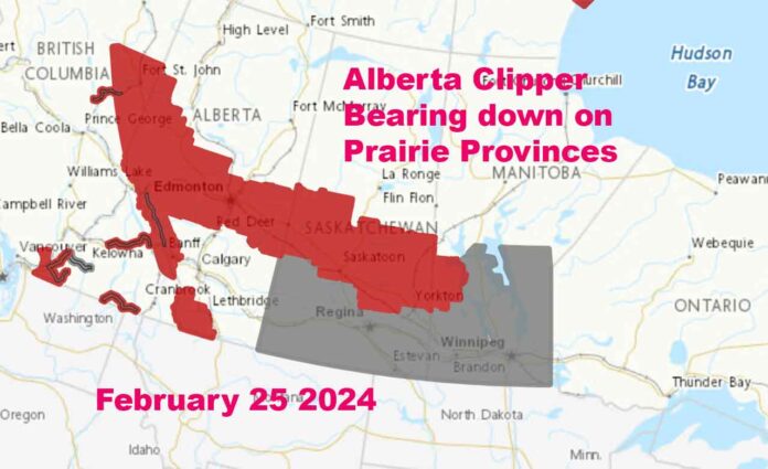
THUNDER BAY – WEATHER – The NetNewsLedger Weather Desk is reporting on the Alberta Clipper and its growing track across Western Canada. While no advisories or warnings are in effect for Ontario as of Sunday morning, this system will impact our region.
An intense Alberta Clipper system is set to sweep across the prairie provinces, including Alberta, Saskatchewan, and Manitoba, starting Sunday night, bringing with it significant snowfall and a dramatic drop in temperatures.
This weather event is expected to impact Edmonton, Saskatoon, and extend into parts of Manitoba, with weather warnings and advisories in effect for multiple regions.
Snowfall and Wind Gusts: A Dangerous Combo
The snow, heavy at times, will primarily affect areas north of the system, with east-central Saskatchewan and west-central Manitoba expected to see around 10 cm of snow, particularly north of the number 5 highway through the Humboldt and Kamsack regions by Monday morning.
Similar accumulations are anticipated for the Hudson Bay and Swan River regions. Northerly gusts between 40 to 60 km/h will accompany the snow, significantly reducing visibility and making travel hazardous in some areas.
A Plunge into the Deep Freeze
Following the snow, temperatures across the affected areas will fall sharply below seasonal averages, with wind chill values reaching minus 30 by Monday night and dipping even lower by early Wednesday morning.
This bitter cold is expected to last until it moderates later in the week, posing risks of frostbite and hypothermia.
Travel Advisory: Proceed with Caution
The rapidly accumulating snow may complicate travel, reducing visibility and deteriorating road conditions. The NetNewsLedger Weather Desk is advising motorists to adjust driving habits accordingly, slow down, and be prepared for sudden stops, especially if visibility is reduced.
Edmonton’s Heavy Snowfall
Edmonton is bracing for heavy snow today and tonight, with forecasts predicting total amounts of 10 to 20 cm, and locally higher amounts up to 25 cm in areas west of Edmonton.
Snowfall is expected to taper off through Monday, but residents should prepare for challenging travel conditions.
Winnipeg’s Weather Shift
Winnipeg, too, is on alert for more winter weather, transitioning from an unseasonably mild February to active winter conditions starting Sunday night.
While southern Saskatchewan and most of southern Manitoba may avoid the heavier snow, a mix of lighter precipitation, including freezing rain, is possible.
A sharp temperature drop and strong northerly winds are expected post-clipper, with morning lows on Tuesday nearing -20 degrees Celsius and wind chill values plummeting to the -30 to -35 range.
Residents across the affected regions are advised to stay informed on the latest weather updates and prepare for the incoming winter conditions. Additional warnings and advisories may be issued as the situation develops.


