Thunder Bay – Wildfire Update – At the time of this update there were 111 active fires in the region. 37 fires are not under control, 9 fires are being held, 45 are being observed and 20 fires are under control.
- There were 18 new fires confirmed in the northwest region by the early evening of July 19.
-
- Sioux Lookout 66 was located near Annis Lake. The 0.1 hectare fire has been declared out.
- Sioux Lookout 67 is located near Annis Lake, approximately 47 kilometres north of Sioux Lookout. The 0.1 hectare fire is being held.
- Sioux Lookout 68 is not under control at 0.1 hectares and is located near India Lake, approximately 32 kilometres north of Sioux Lookout.
- Red Lake 142 is not under control at 200 hectares and is located near the Malette River, approximately 112 kilometres northwest of Red Lake
- Red Lake 143 is located near the Malette River, approximately 114 kilometres northwest of Red Lake. The 3 hectare fire is not under control.
- Sioux Lookout 69 is not under control at 0.1 hectares and is located near walk Lake, approximately 48 kilometres northeast of Sioux Lookout.
- Red Lake 144 was located near Sawmill Bay. The 0.1 hectare fire has been declared out.
- Red Lake 145 is not under control at 1.5 hectares and is located near Killoran Lake, approximately 5 kilometres south of Red Lake.
- Fort Frances 70 is not under control at 0.1 hectares and is located near Nevison Lake, approximately 22 kilometres northwest of Atikokan.
- Red Lake 146 is not under control at 125 hectares and is located near west of Spoonbill Lake, approximately 108 kilometres northwest of Red Lake.
- Red Lake 147 is not under control at 332 hectares and is located 110 kilometres northwest of Red Lake.
- Red Lake 148 is not under control at 1 hectare and is located near Bug Lake, approximately 13 kilometres south of Red Lake.
- Sioux Lookout 70 is not under control at 0.1 hectares and is located near Milner Lake, 59 kilometres northeast of Sioux Lookout.
- Sioux Lookout 71 is not under control at 0.1 hectares and is located near Adamhay Lake, approximately 65 kilometres northeast of Sioux Lookout.
- Nipigon 58 is not under control at 0.1 hectares and is located near
- Red 149 is not under control at 0.1 hectares and is located near Kotyk Lake, approximately 62 kilometres northeast of Red Lake.
- Red 150 is not under control at 0.1 hectares and is located near Kotyk Lake, approximately 60 kilometres northeast of Red Lake.
- Red 151 is not under control at 0.1 hectares and is located near Philips Lake, approximately 59 kilometres northeast of Red Lake.
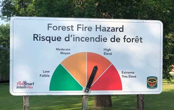
- The wildland fire hazard is high to extreme in the southern Nipigon and Thunder Bay districts as well as a few areas of Red Lake district. The rest of the region is low to moderate following scattered amounts of rain.
- Smoke drift in Red Lake, Kenora, Sioux Lookout, and Nipigon will continue to be experienced by communities in close proximity to wildland fires in those Districts and across the far north. Smoke drift from fires burning in the western provinces of Canada may also be detectable today across much of the province.
- AFFES is currently responding to many fires on the landscape. Stay informed of the location, size, status of all active wildland fires in the province on the interactive fire map atOntario.ca/forestfire
Fires of Note
Red Lake 65 – of concern to Poplar Hill First Nation
- Fire is sized at 16,065 hectares and is now 7km northwest of the community.
- Poplar Hill weather station recorded 25.2 mm of rain overnight – helping to reduce fire behaviour on Red Lake 65.
- Three FireRanger crews assigned to protect the community and critical infrastructure.
- Smoke and visibility pose challenges for using firefighting aircraft in the area.
- The Ministry of the Solicitor General has coordinated an evacuation of the community.
Red Lake 51 – of concern to Deer Lake First Nation
- Fire size is sized at 48,760 hectares and is located approximately 24 kilometres west of the community.
- Deer Lake weather station recorded 24.6 mm of rainfall overnight, helping to reduce fire behaviour on Red lake 51.
- Three crews are focused on the protection of the community and critical infrastructure.
- The Ministry of the Solicitor General has coordinated an evacuation of the community.
Red Lake 77 – Fire of concern to Red Lake
- Fire is not under control at 23,404 hectares.
- At its nearest point Red Lake 77 is approximately 28 kilometres west/northwest of Madsen and is located approximately 33 kilometres west of Red Lake.
- New fire starts to the south of the community continue to be extinguished. Two remaining fires, Red Lake 124 (17 hectares) and Red Lake 126 (25 hectares remain not under control, approximately 11 kilometres south of Madsen and 33 kilometres southwest of Madsen, respectively.
- Crews are working alongside municipal firefighters to protect the community and critical infrastructure.
Kenora 51
- Fire is not under control and remapped at 114,323 hectares.
- Fire has been active over the past several days producing smoke at the local level.
- Three crews and 12 helicopters are assigned to this fire.
- An Incident Management Team is established on the fire.
Restrictions due to forest fire activity in the Red Lake District
The Ministry of Northern Development, Mines, Natural Resources and Forestry, Red Lake District, is advising the public that due to extreme forest fire activity, an Implementation Order is now in effect until further notice that restricts access and use of certain roads and Crown lands.
All travel, use and access to the following areas are prohibited unless authorized by a travel permit issued by the Red Lake District office.
Specifically, all modes of travel and use of the North road, Pineridge Road, Suffel Lake Road, Iriam Road and the portion of Longlegged Road west of the junction of Conifer Road and Longlegged Road.
All modes of travel/access onto Storey lake, Philip lake, Nungesser lake, including the Sahkeesahkahteekoh weesuhkaheegahn (Pringle Lake, Dedicated Protected Area (Ontario Parks)); Woodland Caribou Provincial Park is closed. This includes all access points off Suffel lake Road, Pineridge Road and Iriam Road. Including all modes of travel/access from the Manitoba-Ontario boarder including the Little Grand Rapids dedicated protected planning area, Weeskayjahk Ohtahzhoganiing (Lake country, Dedicated Protected Area) and all Crown land as outlined in the hatched area identified on the Implementation order map.
For information on how to obtain a travel permit please call 807-727-1345.
Restrictions due to forest fire activity in the Kenora District – Werner Lake Road
The Ministry of Northern Development, Mines, Natural Resources and Forestry, Kenora District, is advising the public that due to extreme forest fire activity from the Kenora 51 fire, an Implementation Order is now in effect until further notice that restricts access and use of certain roads and Crown lands.
All travel, use and access to the following areas are prohibited unless authorized by a travel permit issued by the Kenora District Ministry of Northern Development, Mines, Natural Resources and Forestry.
This includes all travel and use of the Werner Lake Road from the Manitoba Border eastward to the end of the road.
All use or occupation of Crown lands, on or within 500 metres of the identified road, is prohibited.
For information on how to obtain a travel permit please call 807-468-2501.
To view a map of the implementation order area at ontario.ca/forestfire, click here.
Restricted Fire Zone in effect
Due to high to extreme forest fire hazard conditions, effective 12:01 a.m. Saturday July 10, the Ontario Ministry of Northern Development, Mines, Natural Resources and Forestry has issued updated boundaries for a Restricted Fire Zone in the Kenora, Fort Frances, Dryden and Thunder Bay Districts and portions of the Sioux Lookout, Red Lake, Nipigon and Wawa Districts. The Restricted Fire Zone will be in effect until further notice. Outdoor fires are banned. Portable gas stoves may still be used BUT must be handled with extreme care. You can learn more about Restricted Fire Zones here. For a more detailed boundary of the Restricted Fire Zone see the attached map, consult the interactive fire map at Ontario.ca/forestfire or find the map here.


