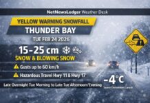
THUNDER BAY – WEATHER – Thunder Bay along with the southernmost communities in Northwestern Ontario are under a Winter Storm Watch issued by Environment Canada. The weather conditions are very likely to impact travel on area highways, and could impact air travel as well.
For Northern Communities, flights out of Sioux Lookout could be impacted.
Winter storm watch in effect for:
- City of Thunder Bay
- Kenora – Nestor Falls
- Vermillion Bay
- Dryden
- Ignace – Upsala – Raith – English River
- Atikokan – Fort Frances
Snow in advance of a low pressure system is expected to begin over Northwestern Ontario near the Minnesota Border early Monday morning. Accumulations of 5 to 10 cm are likely by Monday night.
The heaviest snow is expected to develop Monday overnight and linger Tuesday. Total snowfall amounts of 20 to 30 cm are possible by the time it winds down late Tuesday.
Winds gusting to 50 km per hour could also cause blowing snow in open areas Tuesday and Tuesday night.
Visibility may be suddenly reduced at times in heavy snow. Travel is expected to be hazardous due to reduced visibility in some locations.
Winter Weather Impacting Manitoba
Special weather statement in effect for:
- City of Winnipeg
Southern Manitoba remains in a very active storm track as another Colorado low will be developing tonight and moving northeastward. Current indications have this storm system tracking a little further south then the one last week, so the heaviest snow should remain south of the international border. Areas along the Trans Canada highway corridor will receive 5 to 10 cm with snowfall amounts increasing as you move further south. Areas near the international border over southeastern areas of Manitoba should expect 10 to 20 cm of snow by noon on Tuesday.
Light snow is expected to develop from the southwest late tonight and periods of light snow expected through the day on Monday. The heaviest snow should occur from Monday evening into the early morning hours of Tuesday. The snow should taper off from west to east on Tuesday. In addition to the snow, strong northerly winds gusting to 50 and 60 km/h will develop Monday evening especially over the southern Red River valley. This may produce poor visibilities in snow and blowing Monday evening and Tuesday morning.
Weather warnings may be issued tonight or tomorrow as the system continues to develop.


