
Category 2 Hurricane Marie Blowing Up Surf
California surfers are riding out Hurricane Marie and enjoying big surf. Marie is currently a Category 2 storm and is generating big swells along the west coast of California. Meteorologists say the waves could reach 15 feet in the coming days.
Professional Surfer Laird Hamilton says, “It’s big for California.”
So big in fact, that yesterday’s waves took out around seven wooden pylons that hold up the Malibu pier. And safety is a concern. The Los Angeles County Fire Department is asking people to stay off jetties and beaches.
High Surf Can be Dangerous
The Malibu Pier was closed to pedestrians on Tuesday evening. Earlier in the day, an unconscious surfer was pulled from rough waters nearby earlier. LAFD Emergency workers sought to save the man’s life, performing CPR. However the man was declared dead at the scene.
Surfer Kevin Augnas says, “The waves are big but, the water is moving so fast and as you can see the pier here – people just get swept under it pretty quickly.”
In Newport Beach, surfers took on 12 foot waves. And spectators got quite a show. One of the spectators said, “These guys getting crazy rides and people cheering here on the beach — it’s a good show for free.”
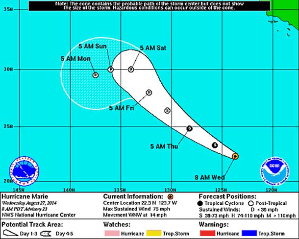
Hurricane Marie Advisory Number 23
NWS National Hurricane Center Miami FL Ep132014
800AM PDT Wed Aug 27 2014
…Marie Steadily Weakening…
Summary of 800 Am PDT…1500 UTC…Information
———————————————-
Location…22.3n 123.7w About 880 Mi…1415 Km W of the Southern Tip of Baja California Maximum Sustained Winds…75 Mph…120 KM/H Present Movement…WNW Or 290 Degrees At 14 Mph…22 KM/H
Minimum Central Pressure…980 Mb…28.94 Inches
Watches and Warnings
——————–
There Are No Coastal Watches Or Warnings In Effect.
Discussion and 48-Hour Outlook
——————————
At 800 Am PDT…1500 UTC…The Center of Hurricane Marie Was Located Near Latitude 22.3 North…Longitude 123.7 West. Marie Is Moving Toward The West-Northwest near 14 Mph…22 Km/H. A Turn Toward The Northwest Is Expected To Occur Tonight Or Early Thursday.
Maximum Sustained Winds Have Decreased To Near 75 Mph…120 Km/H… With Higher Gusts. Marie Will Be Moving Over Progressively Colder Water…And Additional Weakening Is Forecast During the Next 48 Hours. Marie Is Expected To Become a Tropical Storm This Afternoon And A Post-Tropical Cyclone on Thursday.
Hurricane Force Winds Extend Outward Up To 60 Miles…95 Km…From The Center…And Tropical Storm Force Winds Extend Outward Up To 205 Miles…335 Km.
The Estimated Minimum Central Pressure Is 980 Mb…28.94 Inches.
Hazards Affecting Land
———————-
Surf…Swells Generated By Marie Will Continue To Affect Much Of The West Coast of the Baja California Peninsula…The Extreme Southern Gulf of California…And Southern California through Thursday.
Life-Threatening Surf and Rip Current Conditions Are Likely As A Result of these Swells…as well as minor coastal flooding.
FILES: DAILY MOTION / REUTERS / NOAA


