Kenora, Grassy Narrows & Whitedog Get Set for a Winter Wallop
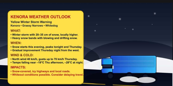
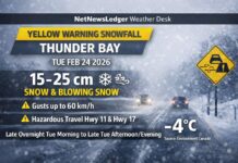
THUNDER BAY – WEATHER – The NetNewsLedger Weather Desk is tracking a Yellow Winter Storm Warning for Kenora, Grassy Narrows, Whitedog and the Lake of the Woods region, with a classic Northwestern Ontario snowstorm lining up for tonight through Thursday. Expect heavy snow, strong winds, blowing snow and dangerous wind chills as this system rolls through.
Current Conditions – Calm but Cold Before the Storm
As of 6:00 AM CST, at Kenora Airport it’s mainly clear and very cold:
-
Temperature: –17.8°C
-
Wind chill: –27
-
Wind: south 16 km/h
-
Humidity: 84%
-
Dew point: –19.9°C
-
Pressure: 101.0 kPa and falling
-
Visibility: 32 km
It’s a bright but bitter start across the Lake of the Woods, with that south wind already hinting at the system pushing in.
Storm Setup – 20 to 35 cm of Snow, Near-Whiteout at Times
Environment Canada rates this as Impact Level: Moderate with High Forecast Confidence. A strong low will sweep into Northwestern Ontario, bringing:
-
Total snowfall of 20 to 35 cm, with local amounts potentially exceeding 35 cm
-
Strong northerly winds, gusting up to 70 km/h on Thursday
-
Blowing snow and drifting snow, with visibility dropping to near zero at times
This storm will hit from west to east, which means areas near the Manitoba border (like Kenora) see the worst of it earlier and start to improve slightly sooner than communities farther east.
Roads, sidewalks and driveways will become snow-covered, icy, and rutted. Some road closures are possible, especially on exposed stretches of the Trans-Canada and secondary highways where drifting snow can quickly build up.
Today – Cloud, Flurries, and Snow Moving In
Today’s forecast calls for a mix of sun and cloud with a 40% chance of flurries, and snow beginning late this afternoon. Local daytime amounts near 2 cm are expected before the heavier snow settles in tonight.
Winds will shift to southeast 20 km/h this morning, drawing moisture and helping build the snow shield. The high reaches about –7°C, but with wind chill it feels closer to –23°C this morning and –15°C this afternoon. That puts exposed skin at real risk, especially for anyone out on the lake or working in open areas.
Tonight – Heavy Snow and Blowing Snow
Tonight is when things ramp up. Expect:
-
Snow, at times heavy
-
Local blowing snow overnight
-
10 to 15 centimetres of accumulation through the night
Winds swing around to northeast 30 km/h, gusting to 50 km/h, and the temperature dips to around –13°C. The wind chill will sit near –13°C this evening and fall to about –21°C overnight, making the combination of heavy snow and drifting a rough mix for anyone travelling late or working the night shift.
By Thursday morning, you’ll likely be waking up to a fresh, fairly deep blanket of snow and ongoing stormy conditions.
Thursday – Storm Peak: Snow, Blowing Snow and Deep Cold
On Thursday, the storm hits its peak over the Kenora region:
-
Snow and local blowing snow through the day
-
Additional 5 to 10 centimetres of snow
-
North winds 40 km/h, gusting to 70 km/h
Temperatures will fall to around –19°C in the afternoon. With the wind, the wind chill will be near –21°C in the morning and plunge to around –32°C in the afternoon. At that level, frostbite can occur quickly on exposed skin, especially if you’re stuck outside with a stalled vehicle or working in open lots and yards.
Conditions are expected to gradually improve late Thursday afternoon or evening near the Manitoba border, then later Thursday night farther east.
Thursday night brings cloudy periods with a 40 percent chance of snow and a low of –28°C, locking in the cold over the region and turning any slush or packed snow into solid ice.
Friday and the Weekend – Cold and Still Unsettled
On Friday, expect a mix of sun and cloud with a 40 percent chance of snow and a high near –13°C, with wind-driven chill continuing to bite. Friday night remains unsettled with cloudy skies and a 60 percent chance of snow, and a low near –18°C.
Saturday continues the pattern with a mix of sun and cloud and a 40 percent chance of flurries, and a high around –15°C. Saturday night features cloudy periods with a 40 percent chance of flurries, and a low near –25°C, keeping the region firmly in the deep-freeze.
By Sunday, there’s a 30 percent chance of flurries and a high near –17°C, with more snow chances Sunday night and into Monday and Tuesday as the storm track continues to favour Northern Ontario.
Travel and Safety – Plan for Tough Going
With 20 to 35 centimetres of snow, strong northerly winds and wind chills near –30°C, travel in and around Kenora, Grassy Narrows, and Whitedog will be challenging at best:
-
Highways and town roads will likely be snow-covered and icy, with drifts forming in open areas.
-
Visibility may be suddenly reduced to near zero in heavy snow and blowing snow.
-
Sidewalks and residential streets will be slippery, rutted and slow to clear.
If you can, reschedule non-essential travel from tonight through Thursday night. If you have to be on the road:
-
Give yourself lots of extra time.
-
Slow down and leave plenty of stopping distance.
-
Make sure your vehicle has winter tires, a full tank, and a winter emergency kit (blanket, flashlight, booster cables, scraper, snacks).
What to Wear in Kenora for This Storm
This is full-on deep-winter wardrobe weather. Start with a thermal base layer (top and bottom) to hold body heat. Add a warm mid-layer such as a fleece or wool sweater, and top it with a windproof, insulated parka that can handle heavy snow and gusty winds.
On your legs, insulated or snow pants are ideal, especially if you’ll be shovelling, snowblowing, or walking the dog in drifting snow. Insulated winter boots with good traction are a must, paired with warm socks.
Don’t forget a toque, insulated mitts or gloves, and a neck warmer or scarf to cover exposed skin. With wind chills pushing into the –30s on Thursday afternoon, having your face, ears, and hands covered can be the difference between uncomfortable and unsafe.
Kenora Weather Trivia – Lake of the Woods Snow Machine
Kenora sits near the eastern shores of Lake of the Woods, a region where Prairie storm systems collide with Arctic airand occasionally tap extra moisture from the west. That geography helps explain why Kenora can see big, multi-day snow events like this, with totals well over 20 centimetres and strong winds sculpting drifts around town and along the highways.
For long-time residents, a forecast calling for 20 to 35+ centimetres of snow, gusts to 70 km/h and wind chills in the –30s is less of a surprise and more of a reminder: in Northwestern Ontario, winter doesn’t mess around.
The Last Word on the Weather:
Kenora, Grassy Narrows and Whitedog face 20–35 cm of snow, strong north winds, blowing snow and wind chills near –32°C from tonight through Thursday night.

