
Thunder Bay – Weather Desk – We are, reluctantly, heading into another messy stretch of winter weather.
While the wind is blowing toward the incoming Colorado Low, the radar map is showing a major system coming in. It could, hopefully be possible that the system could slide south of the city (Let us hope) – but time will tell.
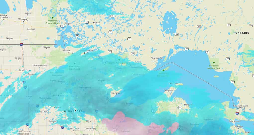
Environment Canada has a Yellow Snowfall Warning in effect for the City of Thunder Bay, warning that 10 to 20 centimetres of snow is expected from this afternoon, Thursday, April 2, into Friday morning, April 3. Forecasters say snow will be heavy at times, with peak snowfall rates of 2 to 3 cm per hour, reduced visibility, local blowing snow, and the possibility of road closures.
Today’s Weather Overview
Current Conditions
At 8:00 AM EDT Thursday, April 2, conditions at Thunder Bay Airport were mostly cloudy and -2.0°C, with a dew point of -4.8°C, humidity at 81 percent, pressure at 102.6 kPa and falling, and an east-northeast wind at 22 km/h gusting to 33 km/h. That was producing a wind chill of -8, while visibility remained good at 32 kilometres ahead of the main snow event.
The day starts relatively manageable, but not for long. Environment Canada says Thunder Bay will stay cloudy, with a 30 percent chance of flurries this morning and early this afternoon, before snow and local blowing snow begin later this afternoon. Daytime accumulation is expected to reach 2 to 4 cm, with east winds around 20 km/h gusting to 40 and a high of -2°C.
The hourly forecast points to a fairly sharp deterioration by mid-afternoon. Environment Canada shows snow beginning around 3:00 PM EDT, then intensifying to snow at times heavy by 6:00 PM, with that heavier snowfall continuing through the evening and overnight hours.
Tomorrow’s Forecast
Expected Conditions
Tonight is the most serious part of this system. Environment Canada is calling for snow at times heavy and local blowing snow, with 10 to 15 cm expected overnight alone. Winds will shift northeast at 20 km/h gusting to 40, the low will be -5°C, and wind chill values will hover near -10. The warning continues to stress that the heaviest snow is expected tonight.
Friday, April 3 stays unsettled even after the worst of the storm moves through. Environment Canada says snow should end near noon, adding about 2 cm more before skies turn cloudy. The daytime high will reach 0°C, but the morning will still feel closer to -11 with the wind chill. Snow chances then continue Friday night, with periods of snow and a low of -4°C.
Saturday, April 4 keeps the wintry pattern going with periods of snow and a high of -1°C, followed by another snowy night and a low of -8°C. Relief finally arrives on Sunday, April 5, with sunny skies and a high of 5°C, before a small chance of flurries returns Sunday night. Early next week looks somewhat calmer, with 1°C on Monday, April 6, and sunny skies with a high of 4°C on Tuesday, April 7.
Travel Outlook
This is a storm to take seriously. Environment Canada says roads and walkways will likely be difficult to navigate, visibility will be reduced in heavier snow, and road closures are possible. For Thunder Bay drivers, the safest window for errands and longer trips is before conditions worsen later Thursday afternoon. Travel Thursday evening through Friday morning looks the most hazardous.
Wardrobe Recommendations
Winter gear is still the right choice. A heavy coat, insulated boots, gloves, and a hat will be useful today, especially once the wind and blowing snow pick up. By tonight, waterproof outerwear will help as the snow intensifies and the combination of wind and cold makes conditions feel harsher than the temperature alone suggests.
Weather Trivia
Thunder Bay’s normal temperatures for this point in early April are about 6°C for the daytime high and -6°C for the overnight low, so today’s sub-freezing high is a little colder than average. The forecast high of 5°C on Sunday, April 5is much closer to what the city would normally expect this time of year.
Synopsis: Thunder Bay weather for April 2, 2026: a Yellow Snowfall Warning is in effect with 10 to 20 cm expected from Thursday afternoon into Friday morning, bringing heavy snow, blowing snow, and hazardous travel.


