KENORA – WEATHER – A classic mid-winter pattern is settled over Kenora and the Lake of the Woods region this morning: lots of cloud, a steady southeast breeze, and wind chills that can sting exposed skin in minutes. The barometer is falling, which often supports lingering cloud and periodic flurries rather than a bright, clearing trend. Snow amounts look light, but the cold and wind make today a “winter-ready” day from start to finish.
The good news is by Monday there is a moderating trend in the forecast with some relief from the cold.
Today’s Weather Overview
Current Conditions (Observed 5:00 AM CST)
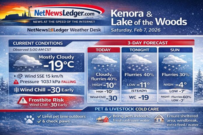
At daybreak, Kenora is mostly cloudy with a temperature of -18.9°C. A SSE wind near 15 km/h is pushing the wind chill to -28. Humidity sits at 72% with a dew point of -22.7°C, and visibility is excellent at 32 km—clear sightlines, but very cold air.
Pressure is 103.1 kPa and falling, which lines up with today’s stubborn cloud cover and on-and-off flurry chances.
What to Expect Today (Saturday)
Expect cloudy skies with a 40% chance of flurries late this morning and this afternoon. Winds become southeast 20 km/h with gusts up to 40 km/h early this morning, which may kick up some light drifting in open areas and make it feel colder than the thermometer suggests.
-
High: -10°C
-
Wind chill: -30 this morning, improving to about -18 this afternoon
-
Risk: Frostbite for exposed skin during longer periods outdoors
-
UV index: 1 (Low)
Expected Conditions: Next 3 Days
Tonight (Saturday night):
Cloudy with a 40% chance of flurries. Southeast wind 20 km/h. Temperature holds near -11°C, with a wind chill near -19.
Sunday, Feb 8:
Cloudy with a 30% chance of flurries. Southeast 20 km/h becoming light early in the morning.
-
High: -4°C
-
Wind chill: -17 in the morning, near -9 in the afternoon
Sunday night: Cloudy with a 60% chance of flurries, low -7°C.
Monday, Feb 9:
Cloudy with a 30% chance of flurries.
-
High: -2°C
Monday night: Cloudy with a 30% chance of flurries, low -8°C.
Overall trend: A gradual warm-up through early week, but the cloud-and-flurry pattern sticks around.
Wardrobe Recommendations
-
This morning: full winter gear—insulated parka, thermal base layer, warm mid-layer, and insulated pants if you’ll be outside for more than a short errand.
-
Wind protection: with early gusts, choose a windproof outer layer, plus a snug neck warmer and mitts (warmer than gloves).
-
Footwear: insulated boots and wool socks; light flurries can turn packed snow into slick spots quickly.
Cold-Weather Care for Pets and Livestock
Pets (Dogs & Cats)
-
Limit time outside: At wind chills near -28 to -30, keep walks shorter and watch for shivering or lifting paws.
-
Protect paws: Snow and ice can ball up between toes. Wipe paws after walks and consider booties. If sidewalks are treated, rinse off salt/chemicals to prevent cracking and irritation.
-
Keep them dry: Wet fur loses heat fast. Towel off snow and moisture immediately.
-
Warm water matters: Ensure fresh water is available and not frozen—dehydration happens in winter too.
-
Know warning signs: Shivering that won’t stop, lethargy, pale/grey skin on ears/toes, or whining can signal cold stress. Bring pets indoors and warm them gradually.
Livestock and Working Animals
-
Windbreak and shelter: A draft-free area (not airtight) is key—bedding should be dry and deep to reduce heat loss through the ground.
-
Water checks: Stock tanks and bowls can freeze quickly. Use safe heaters where appropriate and check multiple times a day.
-
Extra energy needs: Cold, wind, and pregnancy all increase calorie demand. Work with your feeding plan, and make sure mineral/salt is accessible.
-
Watch extremities: Ears, tails, teats/udders, and combs/wattles (poultry) are frostbite-prone. Look for pale skin that becomes firm or darkened.
-
Footing safety: Flurries and freeze-thaw can create hidden ice. Reduce slips with grit/sand in high-traffic areas and keep walkways cleared.
Weather Trivia
A falling barometer like today’s often points to “something changing,” but in winter that change can be subtle—more cloud, a shift in wind, and intermittent flurries rather than a major storm. It’s a small clue that helps explain why skies can stay grey even when snowfall is light.

