
Current Fire Situation in Northeast District
As of June 12, 2023, there are no new fires reported, but 28 wildfires continue to blaze across the Northeast Region. Some of these fires are under control, some are being held, while others are not yet under control. A notable fire, Cochrane 7, measuring 10,719 hectares, is not yet under control, with ongoing efforts to suppress it.
Fires of Note
Specific fires of note include Pembroke 1, Timmins 7, Kirkland Lake 5, and Sudbury 17. Wawa 3 and Chapleau 3 are also being closely monitored as they are still not under control. Firefighters and heavy equipment are working tirelessly to contain these fires.
Travel and Access Restrictions
In response to the fires, the Ministry of Natural Resources and Forestry (MNRF) has issued various travel, use, and access restrictions across the region. This includes multiple areas in the Sudbury District, the Chapleau-Wawa District, and the Hearst-Cochrane-Kapuskasing District. These restrictions are in place to protect public safety and facilitate effective fire suppression. The public is urged to adhere to these restrictions and stay informed about the ongoing situation.
Northeast Fire Region
June 12, 2023
Time of Report – 17:00 EST
Northeast Region
- As of early Monday evening, there are no new reported fires today.
- There are currently 28 active fires in the Northeast Region:
- Fires currently under control include Algonquin Park 6 at 30 hectares, Cochrane 3 at 80 hectares, Cochrane 8 at 35 hectares, Cochrane 10 at 1 hectare, Pembroke 1 at 43.7 hectares, Sault 4 at 14 hectares, Sault 6 at 4 hectares, Sudbury 13 at 0.1 hectare, Sudbury 15 at 3.4 hectares, Sudbury 16 at 14.1 hectares, and Wawa 2 at 105 hectares.
- Fires being held include Algonquin Park 7 at 2.1 hectares and Wawa 3 at 6,678.1 hectares.
- Fires currently not yet under control include Chapleau 3 at 3,916.9 hectares, Chapleau 6 at 1,229 hectares, Chapleau 10 at 4 hectares, Cochrane 5 at 11 hectares, Cochrane 6 at 1,239 hectares, Cochrane 7 at 10,719.8 hectares, Hearst 5 at 90 hectares, Kirkland Lake 5 at 2,300 hectares, Sudbury 10 at 1,082 hectares, Sudbury 17 at 5,227 hectares, Sudbury 18 at 1.5 hectares, Sudbury 19 at 435 hectares, and Timmins 7 at 149 hectares.
- Fires being observed includes Cochrane 1 at 45 hectares.
- Fires that are identified as out since the last report include Sault 3 at 2.8 hectares
Fires of note (also included with Implementation Orders section below):
- Pembroke 1 remains under control at 43.7 hectares.
- Timmins 7 remains 149 hectares and not yet under control. Four FireRanger crews and heavy equipment continue to work to suppress the fire.
- Kirkland Lake 5 remains at 2,300 hectares and is not yet under control.
- Sudbury 17 remains at 5277 hectares and is note yet under control.
Travel, use, and access Restrictions in the Northeast Region – MNRF Sudbury District:
- Under the Emergency Area Order declared on June 5, 2023, the Ministry of Natural Resources and Forestry (MNRF) Sudbury District has put in an Implementation Order to protect public safety and facilitate effective fire suppression. The following restrictions listed be and as outlined on theImplementation Order map are now in effect until further notice. All travel and use of the following areas is prohibited unless authorized by a Travel Permit issued by the Sudbury District MNRF:
o Highway 553 (also known as the Massey Tote Road) south of Cameron Creek at UTM Zone 17 East 408201 North 5136071,
o West Branch Rd south of Fleck Creek in Weeks Township at UTM Zone 17 East 427111 North 5145842,
o Highway 810 (also known as the Massey Tote Rd) south of Ritchie Falls at UTM Zone 17 East 403379 North 5152544,
o John’s Creek Rd at Porter Creek at UTM Zone 17 East 446601 North 5145635,
o Fox Lake Rd at Centre Creek at UTM Zone 17 East 446870 North 5162934,
o Kitt’s Creek Rd at Boon Township Road (Boon Township boundary) at UTM Zone 17 East 417813 North 5136184,
o Highway 553 (also known as the Massey Tote Rd) in Olinyk Township, south of Gervais Township at UTM Zone 17 East 408544 North 5183471,
o Pecors Road at the Joubin, Gaiashik Township boundary at UTM Zone 17 East 389417 North 5136617,
- Under the Emergency Area Order declared on June 5, 2023, the Ministry of Natural Resources and Forestry (MNRF), Sudbury District, has put in an updated Implementation Order to protect public safety and facilitate effective fire suppression. The following actions listed below and on the Implementation Order map must be taken immediately:
o All persons must immediately evacuate the area indicated on the Implementation Order map, including the Townships of; Olinyk, Plourde (south half), Prescott, Redden (west half), Strain, Teasdale, Poncet, Lehman, Lockeyer, Gerow and Gaiashik, unless authorized by a travel permit issued by the Ministry of Natural Resources and Forestry;
- Specifically, all travel and use of Highway 553 (also known as the Massey Tote Rd) south of Cameron Creek at UTM Zone 17 E 408201 N 5136071, as outlined on the attached Implementation Order map within the EAO.
- All travel and use of Highway 810 (also known as the Massey Tote Rd) north of the 17-mile crossover at UTM Zone 17 E 412333 N 5152544, as outlined on the attached Implementation Order map within the EAO.
- All travel and use of Highway 810 (also known as the Massey Tote Rd) south of Ritchie Falls at UTM Zone 17 E 403379 N 5177353, as outlined on the attached Implementation Order map within the EAO.
- All travel and use of Pecors Rd at the Joubin, Gaiashik Township boundary at UTM Zone 17 E 389417 N 5136617, as outlined on the attached Implementation Order map within the EAO
- All persons are prohibited from entering the area indicated on the attached map unless authorized by a travel permit issued by the Ministry of Natural Resources and Forestry.
- Wawa 3, is currently being held at 6,678 hectares.
- Chapleau 3 remains at 3916 hectares and is not yet under control.
- Implementation Orders have been placed for the WAW003 and CHA003 fires below.
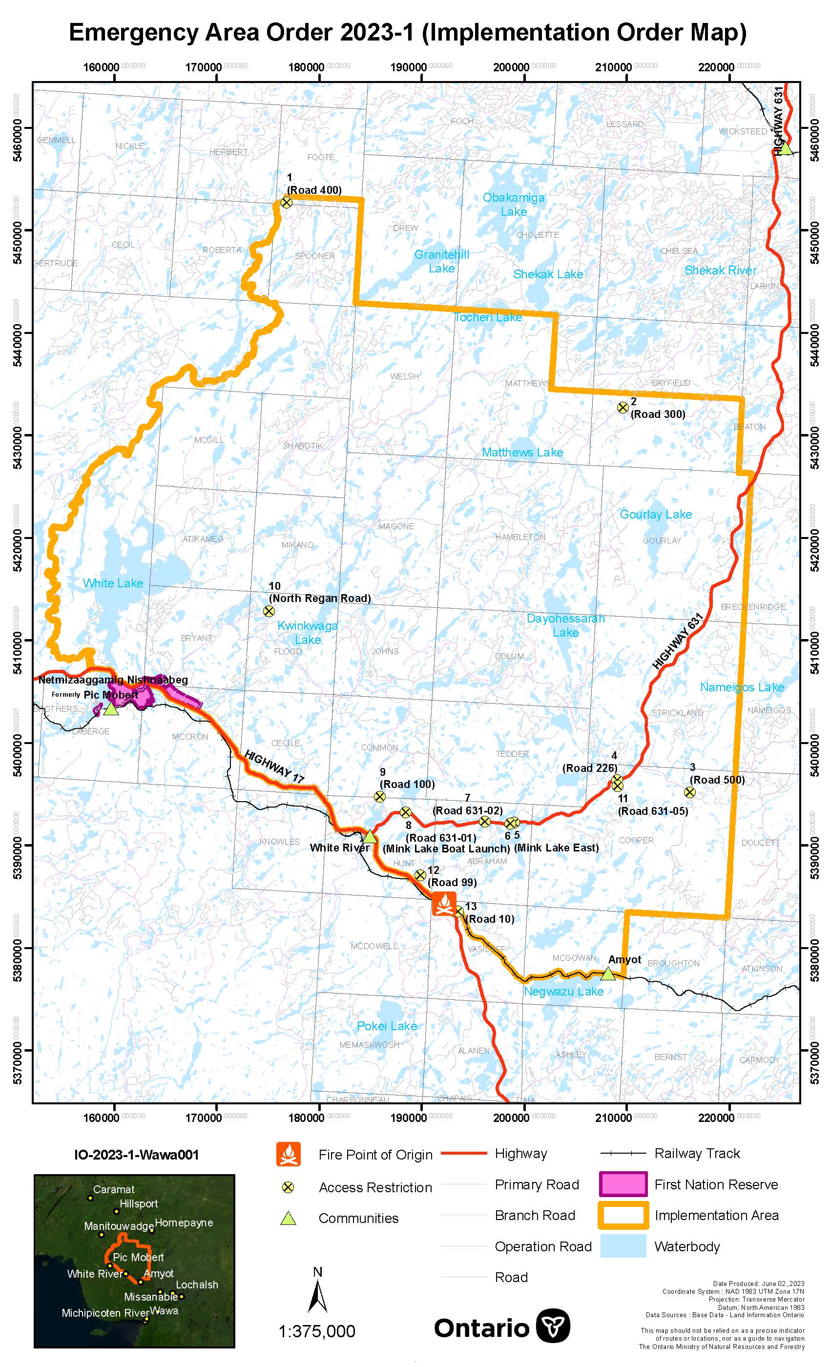
Travel and use Restrictions in the Northeast Region – MNRF Chapleau-Wawa District:
- Travel, use and access Restrictions in the Northeast Region – MNRF Chapleau-Wawa District (WAW003 fire):
o Under the Emergency Area Order declared on May 31, 2023, the Ministry of Natural Resources and Forestry, Chapleau-Wawa District has put in an Implementation Order for the WAW003 fire to protect public safety and to facilitate effective fire suppression. The following restrictions listed below and as outlined on the Implementation Order Map, are now in effect until further notice. All travel and use of the following areas is prohibited unless authorized by a Travel Permit issued by the Chapleau-Wawa District Ministry of Natural Resources and Forestry (MNRF):
o Road 226 west of the intersection of Road 226 and Hwy 631, UTM 16N E650945, N5390845,
o “Mink Lake East” Road north of intersection of “Mink Lake East” Road and Hwy. 631, UTM 16N E641248, N5385975,
o “Mink Lake Boat Launch” Road north of intersection of “Mink Lake Boat Launch” Road and Hwy. 631, UTM 16N E640894, N5385850,
o Operational Road 631-02 north of intersection of Road 631-02 and Hwy. 631, UTM 16N E638389 N5385839,
o Road 99 east of intersection of Road 99 and Hwy. 17, UTM 16N E632494 N5380114,
o Road 10 east of intersection of Road 10 and Hwy. 17, UTM 16N E636467 N5376886,
o “Pierrette Lake” Road south of intersection of “Pierrette Lake” Road and Hwy. 631, UTM 16N E639817 N5385754,
o Road 105 east of intersection of Road 105 and Road 100, UTM 16N E629104 N5392052,
o Road 200 east of intersection of Road 200 and Road 100, UTM 16N E634740 N5401182,
o Road 305 south of intersection of Road 305 and Road 300, UTM 16N E641626 N5413489, and
o Use and occupation of Crown land within 500m in all directions of UTM 16N E642341 N5385979 (Depew River/ Caribou Lake Campsite
o For more information on the travel and use restrictions, see the Implementation Order Map.
- If you have any questions or require travel permits,please contact the Chapleau-Wawa District Office at 705-856-2396.
- Travel, use and access Restrictions in the Northeast Region – MNRF Chapleau-Wawa District (CHA003 fire):
o Under the Emergency Area Order declared on June 9, 2023, the Ministry of Natural Resources and Forestry, Chapleau-Wawa District has put in an Implementation Order for the CHA003 fire to protect public safety and to facilitate effective fire suppression. The following restrictions listed below and as outlined on the Implementation Order Map, are now in effect until further notice. All travel and use of the following areas is prohibited unless authorized by a Travel Permit issued by the Chapleau-Wawa District Ministry of Natural Resources and Forestry (MNRF):
- Dore Road (aka Foleyet Timber Road) south of UTM 17N E381644 N5300986,
- Jerome Road north of the Sultan Industrial Road, UTM 17N E396782 N5266107,
- Mallard Road north of the Sultan Industrial Road, UTM 17N E395324 N5266100, and
- Dore Road (aka Foleyet Timber Road) north of the Sultan Industrial Road, UTM 17N E387440 N5273197
o For more information on the travel and use restrictions, see the Implementation Order Map If you have any questions or require travel permits, please contact the Chapleau-Wawa District Office at 705-856-2396.
- Cochrane 7 is 10,719 hectares and not yet under control. Ground crews continue to work on the southwest end of the fire along with heavy equipment and bucket helicopters.
- Travel, use, and access Restrictions in the Northeast Region – MNRF Hearst-Cochrane-Kapuskasing District:
- Under the Emergency Area Order effective 7:01 a.m. EDT on June 6, 2023, the Ministry of Natural Resources and Forestry (MNRF), Hearst-Cochrane-Kapuskasing District has put in an Implementation Order to protect public safety and to facilitate effective fire suppression. The following restrictions listed below and as outlined on the Implementation Order map are now in effect until further notice. All travel and use of the following areas is prohibited unless authorized by a Travel Permit issued by the Hearst-Cochrane-Kapuskasing District MNRF:
- Travel, use, and access Restrictions in the Northeast Region – MNRF Hearst-Cochrane-Kapuskasing District:
-
-
-
-
- Translimit Road eastwards beginning where it intersects with the Northwest Industrial Road at UTM Zone 17 E 529709 N 5434121
- Translimit Road west of the Ontario-Quebec border at UTM Zone 17 E 608042 N 5423187
- Northwest Industrial Road north of the Abitibi bridge at UTM Zone 17 E 523719 N 5402519
- Use and occupation of Crown lands and roads within the Townships of: Teefy, Edwards, Moody, Rickard, Knox, Kerrs, Galna, Mortimer, Sherring, Marathon, Bowyer, Purvis, Steele, Berry, Sargeant, Bonis, Sweatman, Stimson, Findlay, Henley, Pliny, Scapa, Hepburn, Dempsay, Freele, Challies, Case, Abbotsford, Adair, and Rand.
-
-
-
Restricted Fire Zone
Due to the extreme forest fire hazard, the Ministry of Natural Resources and Forestry has declared a Restricted Fire Zone effective Thursday, June 1, at 12:01 a.m. local time for the districts of Hearst/Cochrane/Kapuskasing, Chapleau/Wawa, Timmins/Kirkland Lake, Sault Ste Marie/Blind River, Sudbury, North Bay, Minden/Parry Sound/Bracebridge, Pembroke, a northern portion of the Peterborough/Bancroft District, and the southeastern portion of the Far North District. No open air burning, including campfires, is permitted within the boundaries of a Restricted Fire Zone. Portable gas or propane stoves may be used for cooking and warmth BUT must be handled with extreme caution. All burning permits are suspended. The Restricted Fire Zone is in place until further notice.


