
THUNDER BAY – Mining – Thunder Bay operated KBM Resources Group has purchased new state-of-the-art remote sensing equipment to complement its existing suite of camera systems and thermal imaging technology. “We are excited about the wide variety of uses our new LiDAR technology has for our clients,” a spokesperson for the company explained. “KBM has the most advanced LiDAR system in Central Canada, and we are the only company in Northern Ontario that owns and operates our own system. We are proud of the assurance we can provide our clients of timely delivery of top quality products.”
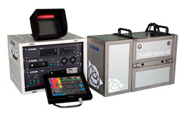 Trimble Harrier Corridor Mapping Systems set a new standard for digital image acquisition and laser scanning. Designed for both aircraft and helicopter operation, the Trimble Harrier 68i is ideal for area mapping.
KBM Resources First in Canada
Incorporating a wide-angle, airborne laser scanner, the Trimble Harrier 68i enables you to extract the most comprehensive information. The laser scanner’s 266 kHz effective measurement rate (at 60 deg scan angle) delivers high point density on the ground to provide the detailed modeling data needed for precise planning, engineering, and monitoring applications. The Trimble Harrier 68i allows flight at a typical maximum altitude of 1,600 meters.
The new equipment (from Trimble) includes:
- Advanced LiDAR sensor head;
- Integrated digital camera;
- Inertial direct georeferencing and advanced flight management system;
- Computer system; and,
- Data storage and backup system.
KBM Resources Group is the only firm in Canada to own a Trimble Harrier 68i LiDAR system.
KBM Resources Group has been providing remote sensing and GIS services for over 20 years. KBM’s aerial survey and geomatics division has expanded considerably, having purchased a third fixed-wing aircraft, initiated plans for construction of a new hangar and nearly doubled its staff over the last year. KBM has nine softcopy workstations for photo interpretation, and up to 17 photo interpreters on staff.
KBM not only captures aerial survey data, but also provides services and products that easily integrate into existing geospatial systems. By turning spatial data into information, KBM can help maximize the power of the data to inform and support clients’ decisions. KBM’s experienced technicians provide geographic data enrichment through spatial analysis, visibility analysis, volumetric analysis, terrain mapping, hydrological modelling, advanced cartographic mapping and modelling, 3D photo-interpretation and client training.
KBM states that the company has the expertise to acquire, analyze, visualize and communicate the spatial information required for environmental and feasibility studies, mineral exploration, site planning and monitoring. KBM has been evaluating the use of LiDAR in collaborative R&D projects for several years, and is confident that this versatile technology has exceptional potential for utilities, forestry, mining, energy and other resource sectors.
KBM will be offering its airborne LiDAR service to clients across Canada and the United States.
Related articles


