NetNewsLedger Weather Desk – Sault Ste. Marie & St. Joseph Island
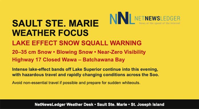
THUNDER BAY – WEATHER DESK – Lake Superior’s snow machine is in high gear this morning, and Sault Ste. Marie is right in the firing line. A Yellow Warning – Snow Squall is in effect, with lake-effect bands continuing to hammer the region through today and into this evening.
As of 7:00 AM EST, Sault Ste. Marie Airport was reporting light snowshower and drifting snow at –9.2°C. Winds are already brisk from the west-southwest at 29 km/h, gusting to 50 km/h, making it feel closer to –18°C in the wind chill.
Humidity is 76 percent, with a dew point of –12.6°C, and visibility is sitting around 16 kilometres between heavier bursts of snow. The barometric pressure is 101.1 kPa and rising, suggesting the system is slowly evolving, but the lake-effect engine is not done yet.
Environment Canada notes this event has a Moderate impact level and Very High forecast confidence, with total snowfall of 20 to 35 centimetres, and even higher amounts possible in the hardest-hit snow bands.
Highway 17 is already closed between Wawa and Batchawana Bay, a strong sign of just how intense the squalls have been along the Lake Superior shore.
Today: Snow Squalls, Blowing Snow, and Near-Zero Visibility at Times
For today, the Soo and St. Joseph Island can expect flurries and snow squalls continuing, with local blowing snowadding to the challenge. Another 10 to 15 centimetres of snow is possible through the day, especially where squalls persist. The wind will strengthen to west 40 km/h, gusting to 60 km/h, driving that snow across open areas and making it very difficult to keep roads fully cleared.
The temperature will hold near –9°C, but the wind chill will be closer to –20°C, so it will feel significantly colder than the thermometer suggests. In the heaviest squalls, visibility may drop suddenly to near zero, and conditions can flip from “manageable” to “white-out” in just a few minutes. It is one of those days where the best travel advice is simple: if you do not have to be on the roads, staying put is the safer option.
Tonight: Squalls Gradually Shift South, Bitter Wind Chill Remains
Tonight, flurries and snow squalls will continue into the evening, with local blowing snow persisting as well. Another 5 centimetres of snow is possible before the lake-effect bands weaken and shift south of Sault Ste. Marie closer to midnight.
Winds will be strong this evening, with northwest 40 km/h gusting to 60 km/h, then turning northeast 30 km/h gusting to 50 km/h early in the evening as the pattern shifts. The temperature will drop to around –16°C, and the wind chill will fall from about –19°C this evening to near –26°C overnight. That puts conditions solidly into frostbite risk territory, especially with blowing snow continuing for part of the night.
Sunday and Monday: Calmer but Still Cold, Flurries Linger
On Sunday, the region finally gets a break from the intense squalls, with a mix of sun and cloud and a high near –9°C. The wind will still be noticeable, from the north around 30 km/h, keeping the wind chill close to –26°C in the morningand about –17°C in the afternoon. It will feel plenty wintry, even with the sun trying to make an appearance.
Sunday night will turn cloudy with a 30 percent chance of flurries, and the low will be around –7°C, which will feel like a mild improvement after the deep chill of Saturday night.
On Monday, expect cloudy skies with a 40 percent chance of flurries and a high near –6°C. Flurries may return again Monday night, with cloudy periods and a 30 percent chance of flurries, and a low around –9°C. The pattern shifts gradually through next week toward slightly milder air and the possibility of mixed precipitation, but for now the Soo remains firmly in winter mode.
What to Wear and How to Prepare in Sault Ste. Marie
This is one of those days where you dress for the wind and the snow, not the number on the thermometer. If you must be out, think in layers and assume you might spend longer outside than planned if roads are slow or buses are delayed.
Start with a thermal or moisture-wicking base layer, add a warm mid-layer like a sweater or fleece, and finish with a proper insulated winter jacket that can stand up to gusty winds and blowing snow. Jeans alone will feel cold and damp quickly; lined pants or snow pants are a much better choice if you are shovelling, walking any distance, or dealing with a stuck vehicle.
On your feet, insulated winter boots with strong tread are essential, as accumulating snow will hide ice and ruts on sidewalks and side streets. Add thick socks for warmth. A toque that covers your ears, warm mitts instead of thin gloves, and a scarf or neck warmer that can be pulled over your nose and mouth will help protect against frostbite in –20 wind chills.
If you absolutely need to travel, especially outside the city, consider packing an emergency kit in your vehicle: a blanket, extra hat and mitts, booster cables, a flashlight, a fully charged phone, and some water and snacks. With Highway 17 already closed between Wawa and Batchawana Bay, conditions have clearly reached the level where plans may need to change quickly.
Lake-Effect Trivia – Why the Soo Gets Hammered
Sault Ste. Marie’s location right at the eastern end of Lake Superior makes it a prime target for lake-effect snow squalls. When cold air blows over the relatively warmer lake water, it picks up moisture and forms narrow but intense snow bands that can dump huge amounts of snow on one stretch of shoreline while another area a few kilometres away sees much less.
That’s why on days like today, one part of the city or nearby communities can be under a heavy, near-whiteout squall, while another spot just outside the band might be staring at light flurries and wondering what all the fuss is about. It’s part of what makes winter in the Soo both challenging and fascinating – the weather is always capable of flipping the script in just a few minutes.
Last Word on the Weather:
Sault Ste. Marie faces intense lake-effect snow squalls today with 20–35 cm possible, blowing snow, Highway 17 closures, and wind chills near –26°C tonight.

