A chilly Friday gives way to a snowy pre-dawn and a milder Saturday
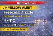
DRYDEN – WEATHER – Residents in Dryden and Vermilion Bay are waking up to a cold, gloomy morning. The weather station at the Dryden Airport said that the sky was cloudy and the temperature was −1.8°C as of 5:00 a.m. CST. With a west-northwest wind of about 13 km/h, it feels more like −6.
The barometric pressure is 101.5 kPa, the humidity is 71%, and you can see 16 km.
Today, temperatures will have a hard time rising before quickly dropping to snow late at night.
Today, there are low clouds, a few snow, and a little breeze.
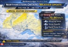
There are still clouds this morning, and there’s a 30% chance of flurries. The northwest winds will slow down to light winds as the day goes on. The high is only −1°C. This morning it felt more like −9°C, and this afternoon it feels more like −3°C. The UV index is modest, at 1. Frosty sheen stays on side streets and shady walkways.
Tonight: The sky will clear up early, then clouds will gather up and snow will fall before dawn.
The skies clear up a little in the evening, but the clouds get thicker after midnight, and there are intervals of snow moving in near morning. The winds stay low, at speeds of up to 15 km/h. The temperature decreases to −7°C, and the wind chill drops from roughly −5°C this evening to close to −12°C before morning. There will be slick patches, especially on ramps and bridges.
Saturday: Snow slows down, there is a chance of a temporary glaze, and then it gets warmer and breezier.
The snow will stop about midday, with about 2 cm of snow in the area. The afternoon will be cloudy with a 30% chance of flurries. During the changeover, there is a chance of freezing drizzle in the morning. In the early afternoon, the west winds pick up to 20 km/h, with gusts up to 40 km/h. The high will be +3°C, although it will feel like −9°C when the sun comes up. Saturday night will be clear and calm, with a low of about −3°C.
Sunday: The sun comes back out, a little above normal for this time of year.
The sky clears up, and the temperature rises to a nice high of about 3°C. It stays bright and cold on Sunday night, with a temperature of about −2°C.
Monday: More clouds, but still moderate
On Monday, the clouds are thicker, and the high in the afternoon is around 4°C. Monday night will be cloudy, and there’s a 30% chance of snow. The low will be at −3°C.
What to dress and how to get there
Dress for the swings: a warm base layer, an insulating sweater or fleece, and a shell that won’t let the wind through will keep you toasty today and tomorrow. For errands in the morning, wear a toque and gloves that keep you warm. Today, when the sidewalks are icy, and again late tonight and early Saturday, wear shoes that are waterproof and have good grip. Before dawn on Saturday and again on Saturday morning, drivers should expect less traction if a short patch of freezing precipitation forms. They should slow down, keep their lights on, and leave additional space.
By the numbers (what’s going on right now)
The wind is blowing from the northwest at 13 km/h, the pressure is 101.5 kPa, the humidity is 71%, and the visibility is 16 km.
Fun facts about the weather in the Dryden region
When a little layer of warm air sneaks in above while the surface air stays close to freezing, the snow quickly turns into a hint of freezing rain. This is how a slippery coating of ice forms on steps and decks without anyone noticing.


