Storm Watch for Thunder Bay Region for Saturday, August 9 2025

7702
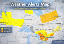
Thunderstorm Warning

Today’s Storm Snapshot – August 9, 2025

Severe Weather: City of Thunder Bay
Sat, Aug 9, 7:55 AM – Sat, Aug 9, 9:55 AM
Severe Thunderstorm Warning in effect until 9:55 AM EDT.
Severe Weather: Cloud Bay – Dorion
Sat, Aug 9, 7:55 AM – Sat, Aug 9, 9:55 AM
Severe Thunderstorm Warning in effect until 9:55 AM EDT.
At 6:55 a.m. CDT (6:55 a.m. EST, 7:55 a.m. EDT), Environment Canada meteorologists are tracking a line of severe thunderstorms capable of producing very strong wind gusts, up to nickel size hail and heavy rain.
This line of severe thunderstorms is located from 25 kilometres northeast of Taman Lake to Mountain Lake, moving east at 60 km/h. Hazard: 100 km/h wind gusts and nickel size hail and heavy rainfall.
Locations impacted include: Thunder Bay, Whitefish Lake, Kakabeka Falls Provincial Park, Kakabeka Falls, Silver Falls Provincial Park, Pigeon River Provincial Park, Cloud Bay, Remicks, Mackies, North Fowl Lake, South Fowl Lake, Raith, Taman Lake, Nolalu, Pigeon River, Sunshine, Flint, Mokomon, Wamsley and Crystal Lake.
Local utility outages are likely. Large hail may cause significant damage and injury. Severe thunderstorm warnings are issued when imminent or occurring thunderstorms are expected to produce damaging hail, wind or rain. Take immediate cover if a thunderstorm approaches.
If outside, protect yourself from flying debris and hail.
Severe Weather: City of Thunder Bay
Sat, Aug 9, 8:00 AM – Sat, Aug 9, 12:05 PM
Severe Thunderstorm Watch in effect until 12:05 PM EDT.
Severe Weather: Cloud Bay – Dorion
Sat, Aug 9, 8:00 AM – Sat, Aug 9, 12:05 PM
Severe Thunderstorm Watch in effect until 12:05 PM EDT.
Currently 73° · Cloudy
Thunder Bay, ON, Canada

Humid; a morning shower in the area, then mostly sunny this afternoon

Today
81°
63°
Humid; a morning shower in the area, then mostly sunny this afternoon

Sun and areas of low clouds in the morning, turning breezy in the afternoon with clouds and hazy sun; humid

Sunday
83°
58°
Sun and areas of low clouds in the morning, turning breezy in the afternoon with clouds and hazy sun; humid

Mostly sunny and warm; a thunderstorm in spots in the afternoon; smoke from wildfires can create reduced air quality

Monday
80°
61°
Mostly sunny and warm; a thunderstorm in spots in the afternoon; smoke from wildfires can create reduced air quality

Clouds and sunshine with a shower; warm; smoke from wildfires can create reduced air quality

Tuesday
79°
56°
Clouds and sunshine with a shower; warm; smoke from wildfires can create reduced air quality

Nice with clouds and sun

Wednesday
78°
56°
Nice with clouds and sun

Sunshine and a few clouds

Thursday
72°
60°
Sunshine and a few clouds

Humid with periods of rain

Friday
76°
59°
Humid with periods of rain

Here’s your high-level outlook with an emphasis on storm potential:

  • Current Conditions: Cloudy and humid with a high of approximately 25 °C and humidex around 35. Light morning showers may give way to improved skies by midday. Thunderstorms are possible—some may be severe, accompanied by heavy downpours, wind gusts up to 100 km/h, and nickel- to quarter-sized hail.

  • Immediate Alert: A Severe Thunderstorm Warning is currently active—stay alert until around 9:55 AM EDT. Environments are favourable for hail, damaging winds, and sudden heavy rainfall .


Multi-Day Outlook: Storm Focus (August 10–15)

Friday & Saturday (Aug 10–11)

  • Sunday (Aug 10): Mornings mix sun and low clouds; breezy, humid afternoons with hazy sun. No immediate severe threat indicated.

  • Monday (Aug 11): Warm but partly sunny. Scattered afternoon thunderstorms are possible; smoke from wildfires may degrade air quality .

Tuesday to Friday (Aug 12–15)

  • Tuesday (Aug 12): Cloudy with occasional showers; another chance for smoky air.

  • Thursday (Aug 14): Generally pleasant with some sun peeking through clouds .

  • Friday (Aug 15): Humid with periods of rain. Thunderstorms could develop—many depending on conditions later in the week.


Wardrobe Recommendations

  • Morning Storm Drill: On Saturday, carry a light rain jacket and consider water-resistant footwear for sudden showers.

  • Afternoon Readiness: Monday and potentially Friday require a sturdy umbrella or rainproof outer layer, in case of pop-up thunderstorms.

  • Sunday & Midweek Comfort: Comfortable short-sleeves are fine, but keep a light sweater handy for early mornings and evenings when skies clear.

  • Air Quality Alert: On Monday and Tuesday, include a light mask or consider staying indoors if wildfire smoke worsens.

Weather Trivia

Did you know? In Canada, a Severe Thunderstorm Warning means that a storm is actively occurring or detected, featuring dangerous weather like large hail (2 cm+), wind gusts of 90 km/h or more, or intense rainfall. These alerts are issued after storms form, while a Watch warns that conditions are ripe for severe storms in the near future.


Previous articleOntario Renews Calls for Removal of Duties on Softwood Lumber Exports
Next articleTariffs Hit Windsor Auto Sector Hard — Northwestern Ontario’s Lumber Sector Could Be Next