Thunder Bay – WEATHER – Thunder Bay is starting Friday under a grey, cloudy sky with light winds—but the bigger story is what’s moving in later today.
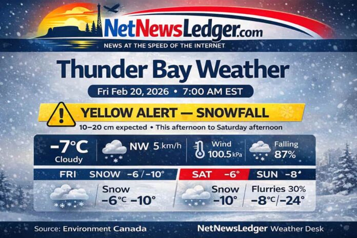
Environment Canada has issued a Yellow Warning – Snowfall for the City of Thunder Bay, with significant snow (10 to 20 cm) expected from this afternoon into Saturday afternoon, bringing moderate impacts and difficult travel conditions for the region.
Current Conditions (7:00 AM EST, Friday, February 20)
As of early morning in Thunder Bay, it’s a classic pre-storm setup: thick cloud cover, damp air, and pressure trending downward—often a sign that more active weather is approaching.
-
Temperature: -7.1°C (≈19°F)
-
Condition: Cloudy
-
Wind: NW 5 km/h
-
Wind Chill: -10
-
Humidity: 87% (dew point -8.9°C / ≈16°F)
-
Pressure: 100.5 kPa and falling
-
Visibility: 24 km
Yellow Alert: Snowfall Warning Details
Environment Canada’s warning calls for 10–20 cm of snowfall, beginning this afternoon and continuing into Saturday afternoon. Light snow may linger into Saturday evening in some areas.
What to watch for in practical terms:
-
Roads and sidewalks will become snow-covered and slippery, and road closures are possible.
-
A westward-moving snowfall band may mean totals vary—Thunder Bay and points west could see lower amounts than areas farther east, depending on how far the band pushes.
-
Highways 11 and 17 may be impacted, especially as heavier snow develops.
Expected Conditions (Next Three Days)
Friday (Today) — Snow builds heavier this afternoon
-
Periods of light snow shifting to snow at times heavy this afternoon
-
Local snowfall: ~5 cm
-
Wind: Becoming north 20 km/h this morning
-
Temperature: Steady near -6°C (≈21°F)
-
Wind chill: Near -14
-
UV Index: 1 (Low)
Friday Night — Heavier snow continues
-
Snow at times heavy
-
Local snowfall: ~5–10 cm
-
Wind: North 20 km/h becoming light in the evening
-
Low: -10°C (≈14°F)
-
Wind chill: Near -15
Saturday (Feb 21) — Snow tapers to lighter, then spotty flurries at night
-
Periods of snow
-
Local snowfall: ~2 cm
-
Wind: Becoming northwest 20 km/h late morning
-
High: -6°C (≈21°F)
-
Wind chill: Near -16
-
Saturday Night: Cloudy, 30% chance of flurries, low -14°C (≈7°F)
Sunday (Feb 22) — Lingering flurries, then a sharp nighttime drop
-
Cloudy, 30% chance of flurries
-
High: -8°C (≈18°F)
-
Sunday Night: Cloudy periods, low -24°C (≈-11°F)
Quick look ahead: Monday trends calmer with a mix of sun and cloud (high near -12°C), but flurries remain possible at times early next week.
Wardrobe Recommendations
With heavy snow and wind chills in the -14 to -16 range today and Saturday—and a plunge toward -24°C Sunday night—dress for both wet snow and deep cold:
-
Outer layer: Waterproof/windproof winter coat (storm hood helps in heavy snow)
-
Mid layer: Fleece or wool sweater to trap heat
-
Base layer: Thermal top + leggings (especially if you’ll be outside longer than 10–15 minutes)
-
Boots: Insulated, waterproof boots with solid tread (consider traction cleats for packed sidewalks)
-
Accessories: Mitts, toque, neck gaiter/scarf (helps prevent wind-burn), and warm socks
-
Driving: Keep a small winter kit—gloves, blanket, scraper/brush—because travel could slow down quickly as snow intensifies
Weather Trivia
Thunder Bay’s winter snow is often influenced by Lake Superior—when cold air flows over relatively warmer lake water, it can help fuel narrow, intense snow bands that boost snowfall totals over short distances. That’s one reason accumulations can vary so much from one part of the region to another.

