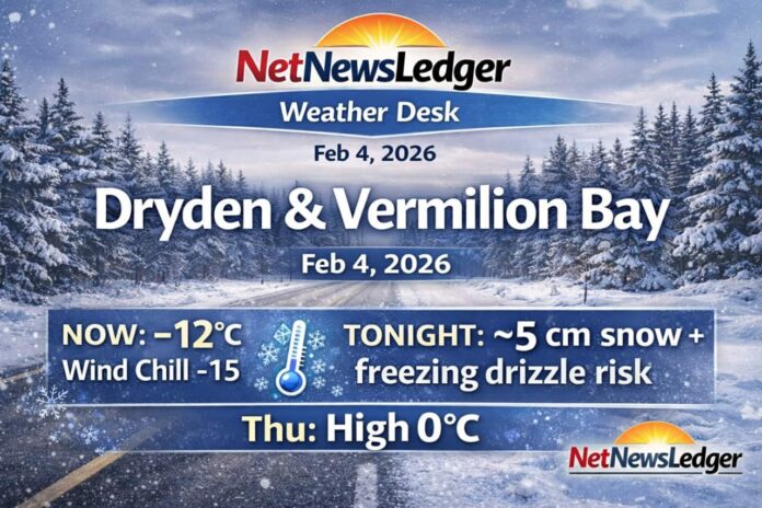
DRYDEN – WEATHER – A stubborn mid-winter pattern continues across the Dryden–Vermilion Bay corridor today: low cloud overhead, a few morning flurries, and a bigger change arriving tonight with steadier snow and a risk of freezing drizzle.
Current Conditions (5:00 AM CST)
Dryden (Dryden Airport): Cloudy and -12.1°C, with NW wind 4 km/h and a wind chill of -15. Humidity is 86%, visibility 16 km, and pressure is 103.0 kPa.
Vermilion Bay (Rawson Lake): Temperature -11.8°C with NW wind 5 km/h and a wind chill of -15. Pressure is 102.9 kPa and rising, humidity 88%. (Condition listed as “not observed,” but the station readings are available.)
Today (Wednesday)
Expect cloudy skies with a 40% chance of flurries this morning. Winds stay light at up to 15 km/h, and the high reaches -9°C. Wind chills run near -21 this morning, improving to about -16 this afternoon. UV index is 1 (low).
Expected Conditions: Next Three Days
Thursday, February 5
Cloudy with a 40% chance of flurries, plus a risk of freezing drizzle in the morning. Wind up to 15 km/h. High near 0°C (a notable warm-up). Morning wind chill near -13.
Friday, February 6
A brighter break: sunny, with a high around -13°C. Friday night turns to cloudy periods with a 30% chance of snow and a low near -22°C.
Saturday, February 7
Cloudy with a 40% chance of snow, high near -9°C. Saturday night: 30% chance of snow, low around -15°C.
Tonight (Wednesday night) — the main “heads up”
Cloudy with periods of snow beginning early this evening, ending before morning, then a 40% chance of flurries. Risk of freezing drizzle before morning. Snow amount near 5 cm. Wind south 20 km/h becoming light after midnight. Temperature holds near -9°C; wind chill around -18 this evening and -13 overnight.
Wardrobe Recommendations
-
This morning: Dress for wind chill -15 and damp-feeling cold under cloud—insulated coat, warm base layer, toque, and mitts.
-
Tonight into Thursday morning: Plan for snow + possible freezing drizzle—water-resistant boots, good traction, and allow extra time for slick parking lots and untreated roads.
-
Thursday’s near-zero high: Melty/slushy patches can refreeze later—keep traction in mind into the evening.
Weather Trivia
Environment Canada lists local normals around -10°C for the daytime high and -21°C for the overnight low right now—so today’s high near -9°C is close to seasonal. Also, daylight is still short: sunrise is around 7:40–7:43 AM CST, with sunset near 5:11–5:13 PM CST.
Summary
Dryden & Vermilion Bay forecast for Wednesday, Feb. 4, 2026: cloudy and -12°C early with light NW winds. 40% chance of morning flurries today, then 5 cm of snow tonight with a risk of freezing drizzle. Thursday warms to near 0°C; sunny Friday turns colder again.


