Thunder Bay’s Morning Scene
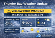
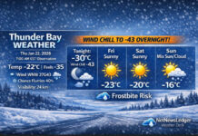
Thunder Bay – WEATHER DESK – Thunder Bay is starting the day under light snow and a chilly -6°C at the airport as of 6:00 AM EST. The air is damp for this temperature with 87% humidity, and the barometric pressure is 99.7 kPa and falling, which fits the unsettled, wintry feel. Winds are light right now from the west-northwest at 5 km/h, giving a wind chill of -8, and visibility is a solid 24 km.
How Today Unfolds
Saturday: Snow Ends, Then the Wind Takes Over
Periods of light snow are expected to end this morning, shifting to cloudy skies with a 40% chance of flurries. The big change is the wind: it becomes west 30 km/h with gusts up to 50 km/h early, and that will move snow around and add a bite.
The temperature will reach about -5°C, then falls to -12°C this afternoon. Wind chill runs near -10 this morning, dropping to around -23 this afternoon—a quick reminder that “warmer” doesn’t always mean “comfortable.”
Tonight: Clearing Near Midnight, But Much Colder
Tonight stays mainly cloudy with a chance of early flurries, then clears near midnight. The wind turns northwest 30 km/h gusting to 60 km/h, and the low drops to -20°C. Wind chill sits near -23 this evening and -28 overnight, with a risk of frostbite if skin is exposed too long.
Sunday and Monday Outlook
Sunday: Brighter Skies, Still Cold
Sunday brings a mix of sun and cloud with a 30% chance of flurries late in the afternoon. High reaches -12°C, with wind chill near -29 in the morning and about -15 in the afternoon. Sunday night turns clearer again, with a low near -23°C.
Monday: Mild-ish, Then Snow Chances Return
Monday looks like a relative break with a mix of sun and cloud and a 30% chance of flurries, warming to about -3°C. By Monday night, clouds thicken with a 60% chance of snow, and the temperature dips to around -5°C.
What to Wear
Today is a “layer and block the wind” kind of day: warm base layer, insulated coat, winter boots with grip, and mitts. Tonight, add a face covering or neck warmer—gusty wind plus deep cold is a combo that doesn’t negotiate.
Travel Note
Even after the snow ends, the stronger winds can create patchy drifting and sudden slick spots, especially on open roads and bridges. Give yourself extra stopping distance and watch for blowing snow in exposed areas.
Weather Trivia
Lake Superior doesn’t just look dramatic—it acts dramatic. When wind direction and cold air line up, it can supercharge local snow and drifting, meaning conditions can change fast even across different parts of the city.
The Last Word on Weather:
Thunder Bay: light snow ends this morning, then gusty west winds and falling temps. Deep freeze tonight to -20 with frostbite risk.


