Thunder Bay Winter Storm: Slush, Heavy Snow and a Flash Freeze on the Way
THUNDER BAY – WEATHER – The Yellow Winter Weather alert remains in effect for the City of Thunder Bay, and this system is far from finished with us.
City streets are wet, slushy and already slick in spots this morning. As the storm continues to roll through today and into Friday morning, travel is going to be a real challenge across the city and on area highways.
As of 6:00 Highway Update
Thunder Bay School Buses
Current Conditions – Mild, Cloudy and Messy Underfoot
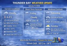
As of 6:00 AM at Thunder Bay Airport, it is cloudy with a damp chill in the air. The temperature is sitting at 1.6°C with a humidity of 88 percent, and a northeast wind at 18 km/h is pushing in the moisture.
Visibility is a decent 24 kilometres, but that will drop at times in heavier snow bands.
The barometric pressure is at 99.1 kPa and falling, which tells us the low-pressure system driving this storm is still working its way through the region.
Roads around Thunder Bay are wet and slushy in many areas, especially where snow has been compacted by traffic. That slush, combined with temperatures hovering around freezing, is exactly the kind of setup that can turn slick very quickly once colder air arrives later in the day and tonight.
Yellow Winter Storm Warning – Heavy Snow, Blowing Snow and Flash Freeze
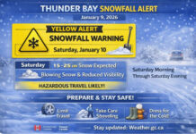
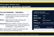
Environment Canada continues a Yellow Winter Storm warning for Thunder Bay with a moderate impact level and high forecast confidence. The storm is expected to persist right through to Friday morning.
Through the day today, snow will continue across the region. Near Lake Superior, including the city itself, some of that snow may temporarily change over to rain or a rain–snow mix this morning. That mix is why totals right along the lakeshore will be somewhat lower. Inland and over the higher terrain north of the city, snow is more likely to stay all snow, with heavier totals.
By this evening and tonight, colder air and strong northerly winds will push across the area. As temperatures drop rapidly below the freezing mark, any rain or slush will freeze, setting up flash freeze conditions. Northerly winds of 30 km/h with gusts up to 50 km/h will combine with falling snow to create local blowing snow and periods of very poor visibility.
Across the full event, total snowfall amounts of 15 to 30 centimetres are expected, with the higher totals over elevated terrain away from the lake. For the City of Thunder Bay, amounts are likely to be toward the lower end of that range, but still enough to snarl travel and keep plows busy.
Today – Snow, Rain Near the Lake, and Increasing Winds
Today’s forecast calls for snow across the region, with periods of rain near Lake Superior as temperatures hover just above freezing. Over the city itself, you can expect a messy mix: wet snow, slush and pockets of rain. Local blowing snow is expected to develop this afternoon as the northerly wind strengthens.
Snowfall amounts will be in the 10 to 20 centimetre range across much of the region, but closer to five centimetres right along the lakeshore where rain mixes in more often. The high for today is near plus 2°C, but as the colder northerly air deepens, the wind chill will feel closer to minus 12°C this afternoon.
Tonight – Snow, Blowing Snow and a Sharp Drop in Temperature
Tonight the mild air gives way to a serious winter chill. Snow and local blowing snow will continue into the overnight period with an additional five to ten centimetres of accumulation. Northerly winds of 30 km/h gusting to 50 km/h will keep snow drifting across roads and open areas.
The temperature will drop quickly, with an overnight low near minus 21°C. The wind chill will sit around minus 12°C early in the evening but fall all the way to about minus 33°C overnight. That is cold enough for frostbite to develop on exposed skin in a relatively short time, especially for anyone stranded on the roadside or walking in open areas.
Friday – Clearing Skies but Bitter Cold
By Friday morning the heaviest of the snow will have moved through, but the cold will remain. A mix of sun and cloud is expected, with a 40 percent chance of a few leftover flurries early in the morning. Northwest winds of 30 km/h gusting to 50 km/h will ease to lighter levels early in the afternoon.
The daytime high for Friday is forecast around minus 12°C. With the wind, the morning wind chill will feel closer to minus 34°C, easing to about minus 17°C in the afternoon. Frostbite remains a concern, particularly in the morning, so dressing for full-on deep winter is essential.
Friday night brings more cloud with a 60 percent chance of additional snow and a low near minus 18°C, keeping travel conditions tricky.
Weekend and Early Next Week – Still Unsettled, Still Wintry
On Saturday, cloud and a 40 percent chance of flurries continue with a daytime high near minus 6°C. Saturday night keeps the theme going with cloudy periods, a 40 percent chance of flurries, and a low around minus 20°C.
Sunday offers a bit of a break with a mix of sun and cloud and a high of about minus 12°C, followed by cloudy periods and a low near minus 19°C Sunday night. Monday stays on the grey side with cloudy skies and a high of about minus 6°C.
By Monday night, another round of snow is possible, with a 60 percent chance and a low near minus 13°C. Tuesday continues the unsettled pattern with a 30 percent chance of snow and a high near minus 9°C, followed by cloudy periods and colder conditions Tuesday night.
Travel and Safety – Slush First, Ice and Drifts Later
This is one of those storms that evolves through several stages. Early on, the main issue is slush and deep, wet snow on streets, sidewalks and parking lots. As colder air takes over later today and tonight, that slush will freeze quickly, turning into rutted, icy surfaces that are much harder to navigate.
Drivers should expect reduced visibility in falling and blowing snow, as well as snow-covered, icy roadways. Sudden whiteouts are possible, especially in open areas and along exposed highway stretches. Allow extra time for travel, slow down, and leave more space between vehicles than usual.
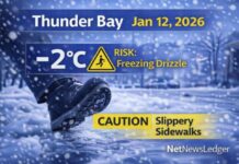
Pedestrians should be prepared for slick sidewalks, slushy puddles turning to ice, and reduced visibility at crosswalks. Good winter boots with solid traction and warm, dry clothing will go a long way to staying upright and comfortable.
What to Wear in Thunder Bay Today and Tonight
This is not the day to gamble on light clothing. Start with a warm base layer, add a cozy sweater or fleece, and top it with a waterproof, wind-resistant winter coat. Waterproof snow pants or insulated pants are a smart choice if you will be shovelling, waiting for transit, or walking any distance in the slush and snow.
On your feet, choose insulated winter boots with good grips to handle slushy sidewalks and icy patches later. A toque, insulated gloves or mitts, and a scarf or neck warmer will help keep the wind and wet snow off your face and neck. As the temperature drops tonight and wind chills plunge into the minus 30s, having all skin covered becomes more than comfort – it becomes safety.
Thunder Bay Weather Trivia – Lake Superior’s Snow-Making Engine
Thunder Bay’s winter storms often come courtesy of low-pressure systems that track across the Prairies and northern U.S. states before pulling in moisture from Lake Superior. When that moist air meets Arctic air dropping in from the north, the result is classic Lake Superior snow: heavy, persistent, and occasionally mixed with rain right along the shoreline when the air is just warm enough.
The hills north of the city, with their slightly higher elevation, can squeeze even more snow out of the same system, which is why snowfall totals there can run higher than down by the lakeshore. It is one of the reasons local snow totals can vary so much from neighbourhood to neighbourhood during a single storm.
The Last Word on Today’s Weather:
Thunder Bay faces heavy snow, slush, strong north winds and a flash freeze through Friday morning, with 15–30 cm of snow and challenging, icy travel conditions.

