NetNewsLedger Weather Desk – 5:20 AM EST, Wednesday, November 26, 2025
THUNDER BAY – WEATHER – A Winter Storm Warning remains in effect for the City of Thunder Bay this morning as a storm system continues to bring heavy snow, strong winds, and blowing snow to the region.
Travel conditions, especially on area highways, are expected to be challenging to hazardous through today and tonight.
Rural school buses in Thunder Bay are cancelled this morning.
Current Conditions – Thunder Bay Airport (6:00 AM)
-
Temperature: -2.7°C (Wind chill: -9)
-
Condition: Light snow and drifting snow
-
Pressure: 100.7 kPa (falling)
-
Humidity: 84%
-
Wind: N 23 km/h, gusting 43 km/h
-
Visibility: 4 km
Snow and blowing snow are already reducing visibility across parts of the city, and conditions are expected to worsen as winds strengthen through the morning.
Winter Storm Warning Details
Warning area: City of Thunder Bay
Event type: Winter storm with heavy snow and blowing snow
What:
-
Total snowfall amounts: 10 to 20 cm
-
Visibility: Significantly reduced in heavy snow and blowing snow, at times near zero
When:
-
Continuing today (Wednesday) and ending tonight
Additional Information:
Strong northerly and northwesterly winds will increase this morning, with gusts up to 70 km/h. These winds, combined with fresh snow, will lead to widespread blowing snow, drifting, and very poor visibility—especially in open and exposed areas.
Travel will likely be challenging, and brief whiteout conditions are possible.
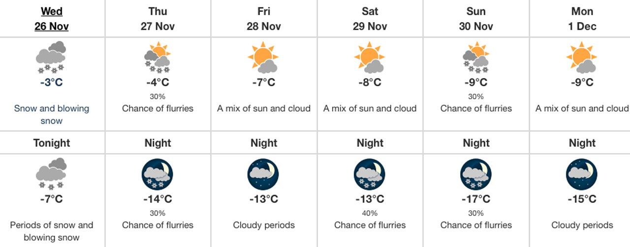
Today and Tonight
Today – Wednesday, November 26
-
Weather: Snow and blowing snow
-
Snowfall: Additional 5 to 10 cm
-
Wind: Northwest 40 km/h, gusting to 70 km/h
-
High: -3°C
-
Wind chill: Near -13°C
Expect periods of heavier snow and frequent gusts that will reduce visibility, particularly along highways and open stretches near Lake Superior.
Tonight – Wednesday Night
-
Weather: Periods of snow
-
Blowing snow: Blowing snow this evening, local blowing snow overnight
-
Wind: Northwest 40 km/h, gusting to 70 km/h
-
Low: -7°C
-
Wind chill: Near -15°C
Conditions slowly begin to improve overnight, but slick roads, drifting snow, and poor visibility will remain a concern into Thursday morning.
Extended Forecast into the Weekend
Thursday, November 27
-
Mainly cloudy with a 30% chance of flurries
-
Wind northwest 30 km/h, gusting to 50
-
High: -4°C, wind chill near -16°C
Thursday Night:
-
Cloudy periods with a 30% chance of flurries
-
Low: -14°C
Friday, November 28
-
A mix of sun and cloud
-
High: -7°C
Friday Night:
-
Cloudy periods
-
Low: -13°C
Saturday, November 29
-
A mix of sun and cloud
-
High: -8°C
Saturday Night:
-
Cloudy periods with a 40% chance of flurries
-
Low: -13°C
Sunday, November 30
-
Mix of sun and cloud with a 30% chance of flurries
-
High: -9°C
Sunday Night:
-
Cloudy periods with a 30% chance of flurries
-
Low: -17°C
Colder, more stable weather settles in behind the storm, but wind chills and occasional flurries will keep it feeling very wintry.
Travel Advisory – Highways and Local Roads
With snow, blowing snow, and strong winds, travel in and around Thunder Bay today will likely be difficult, especially on:
-
Highway 11/17 in and out of the city
-
Rural and exposed roadways
-
Overpasses and open stretches where drifting is common
Drivers should:
-
Slow down and allow extra time to reach their destination
-
Keep headlights on and increase following distance
-
Be prepared for sudden drops in visibility due to blowing snow
-
Carry a winter emergency kit in their vehicle
For the latest highway conditions, closures, and incidents, visit:
This service provides up-to-date road information for highways across Ontario.
Stay tuned to NetNewsLedger for further updates from the Weather Desk as this winter storm continues to impact Thunder Bay.


