THUNDER BAY – WEATHER – There are Weather Advisories and Snowfall Warnings out this morning across Western Ontario.
THUNDER BAY – SNOWFALL Warning
It is a cold rainy start for Wednesday in Thunder Bay. The weather forecast is for that rain to change to snow falling at times heavy this morning.
Periods of snow will likely continue through Thursday.
Lakehead University’s Thunder Bay campus will remain open today as we continue to monitor inclement weather conditions and the forecast. Employees or students who can work, teach, or learn remotely may do so. If you choose to come to campus, please take care while travelling.
City of Thunder Bay Child Care Centres (Algoma, Grace Remus, Ogden, Woodcrest) are opening at their regular times this morning (Wednesday, April 6, 2022).
Snowfall amounts of 15 to 25 centimetres are expected before it ends. Winds are strong from the east at 40 km/h gusting to 60 diminishing, however they will be slowing down to 20 km/h gusting to 40 early this morning.
Temperature steady near +1. UV index 1 or low.
Tonight the forecast is for snow at times heavy with up to two more centimetres likely. Winds are going to be blowing from the northeast 30 km/h gusting to 50. Temperature steady near plus 1.
FORT FRANCES
Snow. In a word that is the forecast for FORT FRANCES. There is a Special Weather Statement in effect. Total snowfall amounts of 5 to 10 centimetres are expected. Winds are from the northeast at 20 km/h becoming light early this afternoon. Temperature steady near +2.
UV index 1 or low.
Tonight more snow with an additional amount of 5 centimetres likely. Winds will shift becoming north 30 km/h gusting to 50 after midnight. Temperature steady near zero.
Dryden and Vermilion Bay
Snow is in the weather mix for Dryden and Vermilion Bay. 5 to 10 centimetres of the white stuff is expected today. Winds will be from the northeast at 20 km/h gusting to 40. The temperature will remain steady near plus 2.
UV index 1 or low.
Tonight will see more snow with another 5 centimetres likely. Winds will be from the northeast at 40 km/h gusting to 60. Low overnight of =3. Wind chill -11 overnight. Road conditions are likely to be slippery, use caution and decide if that trip is really worth it.
Sachigo Lake
It is -1 this morning headed to a high of +2 in Sachigo Lake. Periods of light snow should be ending near noon then cloudy with a 40 per cent chance of flurries. There is a risk of freezing drizzle this morning, if you are flying check with your airline. Winds will be from the northeast at 40 km/h gusting to 60.
Wind chill -10 this morning. UV index 2 or low.
Tonight will see partly cloudy skies. Winds will continue from the northeast at 30 km/h gusting to 50. Low overnight of -8. Wind chill -17 overnight.
Duluth – Grand Marias
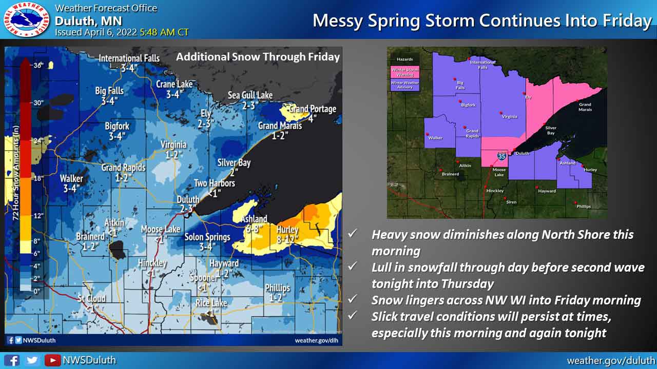
A messy spring storm will continue to affect the Northland today and tomorrow. Heavy snowfall along the North Shore of Lake Superior will diminish this morning with a lull in the snowfall before a second wave arrives for tonight into Thursday. Most of the snow will end from west to east Thursday night, but some snow will linger across Northwestern Wisconsin into Friday morning.
Roads are partially to completely covered with snow across much of northeastern Minnesota this morning along with portions of northern Douglas and northern Bayfield counties in northwest Wisconsin. Drive with caution and allow for extra time to reach your destination this morning.
Slick travel conditions will persist at times, especially this morning and again tonight.


