")
Part 1 – Recent Open Houses & Project Overview
GREENSTONE – MINING – On Wednesday, November 18, Greenstone Gold Mines hosted open houses in Longlac and Geraldton. At each venue, more than 50 residents turned out for updates on the environmental assessment process.
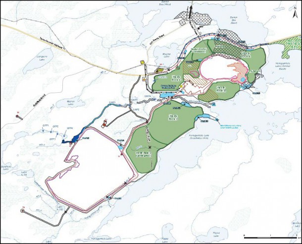
The company proposes an open pit gold mine in the area where Highway 17 meets Geraldton’s Michael Power Boulevard. Across several square kilometres, the landscape and infrastructure will undergo revolutionary changes. The lifespan of the open pit mine is projected to be 15 years.
In early 2015, Premier Gold Mines Ltd. partnered with Centerra Gold Inc. to form the new company that has since been named Greenstone Gold Mines. At that time, the company predicted that over the course of 15 years the mine would produce 3,041,000 ounces.
The Municipality of Greenstone and the residents support the company’s initiative. The environmental assessment is being carried out by Stantec Consulting Ltd., which has noted the continuing decline of Greenstone’s population, the economic downturn in this region, and an unemployment rate (13% in 2011) higher than the provincial average.
The footprint of the main open pit will eventually measure approximately a kilometer and a half long (east to west), just under a kilometre wide, and half a kilometre deep. Some smaller satellite pits are also planned. The overburden and waste rock from the pit will require extensive storage areas. Several features of the Geraldton landscape will entirely disappear, including the Discover Geraldton Interpretive Centre, the 18-hole Kenogamisis Golf Club course, and the housing subdivisions known as MacLeod Townsite and Hardrock Townsite. Scheduled for relocation and rebuilding are portions of Highway 11 and Michael Power Boulevard, the relatively new Ontario Provincial Police building, some power transmission lines, the Ontario Hydro substation, and the MTO patrol yard. The historic mining headframe of the old MacLeod-Cockshutt gold mine is slated for demolition unless the Municipality makes the decision to preserve and relocate it.
The project development area is bounded on three sides by the waters of Kenogamisis Lake ̶ Barton Bay to the north, and the Central Basin and Southwest Arm to the east and south. The initial local study area encompassed a great deal of the watershed of Kenogamisis Lake. Water plays a big role in the environmental assessments.
Steve Lines, Manager, Permitting and Environmental Assessment, guided the audience through a slide presentation at the open houses. Lines stated the company anticipates mine construction occurring during 2017 and 2018, with mine operation commencing in 2019 and running to 2034. Mine closure and reclamation will occur during five subsequent years. Mine operation will entail 340 direct employment opportunities, with an undetermined number of people employed indirectly in local and regional businesses.
Ian Horne, Director, Environment and Community Relations, fielded many of the questions from the audience. Horne stated that the project’s local study area was considerably larger than the project development area (the area directly impacted). The latter area resembles a parallelogram measuring approximately 9 km long (NE to SW) and 3 km wide. This vast area will be utterly transformed.
The company, through its consulting firm, Stantec, has been collecting baseline data for some time. Scientists, technicians, and sundry experts have been conducting studies and analyzing data in compliance with federal and provincial environmental assessment guidelines. By the end of January 2016, the company will submit its draft. The public will also have opportunities to comment on the draft.
In 2014, after the open houses on the draft Terms of Reference, public comments were tabulated and made available online. There has not been a similar report for the July 2015 open houses. In response to a question from the audience, the company said it will soon make available those public comments.
In response to a question addressed to Horne, the audience learned that the cost of relocating the Hydro One Networks transformer substation alone will exceed $30 million. The new substation would be built to current standards. The company is currently buying out all businesses, operations, and homeowners in the two townsites, and conducting discussions with the golf club and the Municipality. All costs incurred are apparently the responsibility of the project proponent, the company. The company has not published any figures to date.
The scope of the project development area is mind-boggling. The open pit will overtake some of the tailings of the historic mines of MacLeod-Cockshutt and Hardrock. The historic tailings, such as those under the Interpretive Centre, will be trucked far to the southwest. West of the the Southwest Arm of Kenogamisis Lake, a huge area will be enclosed by dams as a tailing management facility. South of, and not far from, the open pit, ore milling and processing will generate more tailings. The slurry will be piped across country to this management facility. Lines told the writer that the historic tailings may be isolated within the facility in order to be easily accessed if the company should decide at some later date to re-process them to extract residual gold.
In response to a question from the audience, Horne stated that the Hardrock Project is not making any assumptions about the extension of mining activities beyond the open pit. He did say that there is the potential for underground mining after the pit closes, but that possibility does not factor into current thinking. He pointed out that the greenstone formation associated with gold values extends west all the way to Beardmore. The company has acquired major properties along that belt. Said Horne, “There’s a real potential that there could be another Red Lake or Timmins,” alluding to well-known gold camps.
Following the slide presentations, audience members explored several large-scale panels of maps and data, and engaged in one-on-one discussions with officials.
In this phase, the company is accepting public comments for just a few more days. Interested parties can send them to cheryl.lesperance@ggmines.com or dina.quenneville@ggmines.com.
Parts 2, 3, and 4 will explore the environmental assessments of the area’s natural and cultural heritage resources.
Edgar J. Lavoie is a writer based in Greenstone, whiskyjackpublishing.ca.


")


