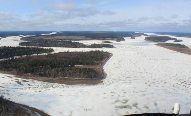
As of 5:45pm breakup still remains at mileage 151 (Tommyville). The ice jam still remains approximately 5 miles long with high water levels behind the leading edge of break-up and pack ice. This is expected when breakup stops. All low lying areas along the river banks are experiencing over bank flooding associated with the current location of this breakup.
At the end of the ice jam there is open water with very minimal ice floating down.
North French River’s current location of breakup remains about ¼ of a mile upstream from the mouth of this river. The water levels in this waterway are moderate to high with gradually increasing flow rates to help push the ice out and in to the Moose River. There will be 2-3 ice flows coming out of this waterway due to open stretches of water that are approximately 10-15 miles apart.
Kwatabohegan River remains intact with increased open sections and the water levels remain high and the flow rates remain high. There is over bank flooding in low lying areas along the shoreline of this waterway.
Cheepash River has broken up to the mouth and extends about ¼ mile downstream of the train crossing. The water levels and flow rates remain moderate to high.
Moose River water levels are increasing and the flow rates are increasing around Moose Factory and Moosonee. This waterway is intact up to mileage 151 at the time of flight, with open sections along all shorelines and where there is fast moving water. Due to the increasing water levels behind the breakup. Expected time of arrival of breakup near Moose Factory and Moosonee could be between 12-72 hours or more.
When breakup nears Moosonee and Moose Factory, we can expect to see water levels increase and flow rates increase.
Please take the time to remind your children to remain clear of breakup when it reaches Moosonee/Moose Factory.
Have a great evening Moosonee/Moose Factory…
Michael Delaney/Curt Wesley – Moose Factory Emergency Operations Coordinators
Steve Crown – Moosonee Community Emergency Management Coordinator
Moosonee is located on the Moose River 12 miles south of James Bay at a latitude 51 N 07′ and longitude 80 W 35′ . The town site is in the Hudson Bay Lowlands, the largest wetland area on earth. Originally settled as a fur trading post by Revillion Freres of Paris in 1903 in competition with the Hudson Bay Company, the town grew in importance with the arrival of the rail in 1932 when Moosonee became a transportation hub for the James Bay coastal communities. Moosonee serves as a gateway to the north and a launching point for further destinations, whether across the Moose River to Moose Factory, or further north up the western coast of James Bay to our neighbouring First Nation communities.
Moosonee is not connected to the road system in Ontario and all travellers arrive in Moosonee by train or plane. Scheduled rail services are provided by Ontario Northland, from Cochrane, Ontario. Scheduled air services are provided by Air Creebec & Thunder Airlines. There are also several small charter air companies based in Moosonee.


