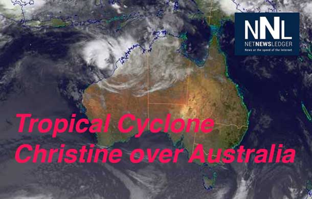

intensify further as it moves towards the Pilbara coast.
Cyclone Christine Intensifying
BRISBANE – Weather – Tropical Cyclone Christine is expected to make landfall with sustained winds of 165 kilometres per hour. The storm is already impacting the coastline of Western Australia.
The storm was first tracked by NASA. The Space Agency reports, “Low pressure System 98S appears ripe to form into Tropical Cyclone 05S as NASA satellite imagery is showing some hot towering clouds in the storm and heaviest rains south of the center. System 98S is expected to become a tropical depression on Saturday, December 28, and alerts are already in effect.
NASA and the Japan Aerospace and Exploration Agency’s Tropical Rainfall Measuring Mission or TRMM satellite passed over developing System 98S on December 26 at 1140 UTC/6:40AM EST and noticed a “hot tower” thunderstorm reaching heights of about 17 km/10.5 miles.
A “hot tower” is a tall cumulonimbus cloud that reaches at least to the top of the troposphere, the lowest layer of the atmosphere. It extends approximately 9 miles/14.5 km high in the tropics. These towers are called “hot” because they rise to such altitude due to the large amount of latent heat. Water vapor releases this latent heat as it condenses into liquid. NASA research shows that a tropical cyclone with a hot tower in its eye wall was twice as likely to intensify within six or more hours, than a cyclone that lacked a hot tower.
When TRMM passed over System 98S again on December 27 at 1222 UTC/7:22 a.m. EST, it observed heavy rainfall occurring falling at a rate of 1.4 inches/35.5 mm per hour. The heaviest rainfall appeared in a band of thunderstorms south of the center of circulation.
TROPICAL CYCLONE ADVICE NUMBER 20
Issued at 8:59AM WST on Sunday 29 December 2013
A Cyclone WARNING is current for coastal areas from Cape Leveque to Mardie, including Broome, Port Hedland and Karratha.
A Cyclone WATCH is current for the coastal areas from Mardie to Exmouth, including Onslow, and extending inland to Paraburdoo and Newman.
At 08:00AM WST Tropical Cyclone Christine, Category 2 was estimated to be 295 kilometres west northwest of Broome and 445 kilometres north northeast of Port Hedland and moving southwest at 10 kilometres per hour parallel to the coast.
Tropical Cyclone Christine lies off the west Kimberley coast and is expected to intensify further as it moves towards the Pilbara coast.
Gales with gusts to 100 kilometres per hour are possible on the west Kimberley coast south of Cape Leveque today. Heavy rainfall is expected today in coastal areas of the west Kimberley and adjacent inland parts.
As the tropical cyclone begins to approach the Pilbara coast, gales are expected to extend further west along the Pilbara coast to Whim Creek late today or early on Monday.
During Monday gales and heavy rainfall are expected to extend to Karratha and possibly as far west as Exmouth, and then to the inland Pilbara late Monday and on Tuesday. If Christine continues to develop as expected a severe tropical cyclone impact on the Pilbara coast is likely late on Monday or early on Tuesday, with VERY DESTRUCTIVE winds with gusts in excess of 165 kilometres per hour near the cyclone centre.
People on the coast between De Grey and Mardie, including Port Hedland and Karratha, are warned of the potential for a DANGEROUS STORM TIDE late Monday night or early Tuesday morning. Tides may rise significantly above the normal high tide mark with DAMAGING WAVES and DANGEROUS COASTAL INUNDATION.
DFES State Emergency Service (SES) advises of the following community alerts:
BLUE ALERT: People in or near coastal areas between the Dampier Peninsula and Onslow, including Broome, Port Hedland, South Hedland, Whim Creek, Roebourne, Point Samson, Wickham, Karratha, Dampier and Onslow, and extending inland to Marble Bar and Pannawonica, need to prepare for cyclonic weather and organise an emergency kit including first aid kit, torch, portable radio, spare batteries, food and water.
People needing SES assistance can call 132 500. In a life threatening situation call 000. For more safety tips visit www.dfes.gov.au
Details of the Tropical Cyclone Christine at 8:00 am WST:
- Centre located near…… 16.5 degrees South 119.9 degrees East
- Location accuracy…….. within 45 kilometres
- Recent movement………. towards the southwest at 10 kilometres per hour
- Wind gusts near centre… 130 kilometres per hour and intensifying
- Severity category…….. 2
- Central pressure……… 982 hectoPascals
The next advice will be issued by 12:00 pm WST Sunday 29 December.
Cyclone advices and State Emergency Service Community Alerts are available by phoning 1300 659 210


