LOS ANGELES – TECH – In California, the Santa Ana winds produce dry hot conditions that make the area a tinderbox. Fires raging across Souther California have had firefighters battling growing, brush-fueled wildfires.
While Northwestern Ontario is experiencing winter conditions with freezing rain, the people in California would likely love to share the hot weather in exchange for some fire dousing rain.
California Wildfires Raging
Early Friday those wildfires had reached the beach in Ventura County, and were pushing toward the upscale city of Malibu, according to NBCnews.com.
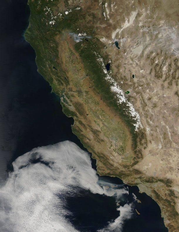
This massive fire, dubbed the Springs Fire is visible from space. Several years ago, flying into California, to the John Wayne Airport, both the light from the fires, and the strong smell of smoke in the cabin was noticeable from over 150 kilometres out from the airport.
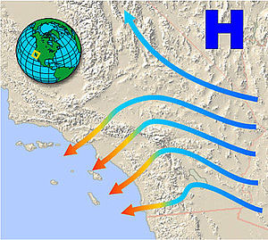
This “monster” of a wildfire has been made worse by howling Santa Ana winds and unusually dry vegetation. The National Weather Service defines Santa Ana winds as “Strong down slope winds that blow through the mountain passes in southern California. These winds, which can easily exceed 40 mph, are warm and dry and can severely exacerbate brush or forest fires, especially under drought conditions.”
As of 02:00AM local time in California on Friday May 3rd, the wildfire was within seven or eight miles of Malibu California.
Ventura County Fire Department spokesman Bill Nash said, “Weather conditions are not cooperating in the containment of this fire”.
The Weather Channel has predicted dry winds from offshore that will bring gusts of 40 to 50 miles per hour to the Southern California region on Friday the 3rd which could easily spread the fire. A complication to the winds is the extremely dry plant life left from a season in which only about five inches of rain fell in the area.
The Springs Fire grew to 10,000 acres and was ten percent contained as of early Friday morning, according to the California Department of Forestry and Fire Prevention.
Evacuations took place Thursday, and as of Friday morning 15 homes had been damaged. More than 2,000 homes and 100 commercial properties were under threat from the fire and those numbers could grow with weather conditions today (May 3).
Currently the fire is burning in a rural area outside of Malibu, but it doesn’t have to go very far to get to some expensive homes and more populated areas. It’s current direction has it burning down the mountainside toward Malibu.
Firefighters expect to receive help from tankers and helicopters in the air Friday morning, according to a release from the Ventura County Fire Department.
The cause of the fire remained under investigation Friday. There had been no lightning or other natural fire-starting phenomenon in the area when the blaze began, Nash said.
This natural-color satellite image was collected by the Moderate Resolution Imaging Spectroradiometer (MODIS) aboard the Aqua satellite on May 02, 2013. Actively burning areas, detected by MODIS’s thermal bands, are outlined in red.