
THUNDER BAY – WEATHER – Environment Canada has updated the weather warning to a Winter Storm Warning for Thunder Bay and Northwestern Ontario along with areas northeast of the City of Thunder Bay.
The weather is likely to have a real impact on local highways. If you are planning travel in the area forecast to be impacted by the storm, it is likely to reconsider those plans.
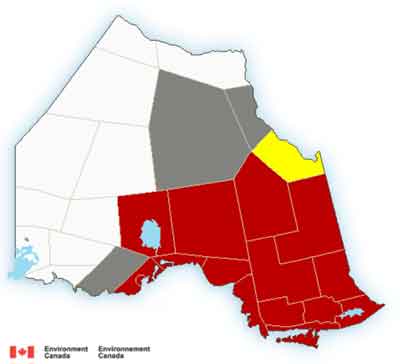
Winter storm warning in effect for:
- City of Thunder Bay
- Cloud Bay – Dorion
- Kakabeka Falls – Whitefish Lake – Arrow Lake
- Beardmore – Jellicoe – Macdiarmid
- Geraldton – Longlac – Caramat
- Manitouwadge – Hornepayne
- Nakina – Aroland – Pagwa
- Marathon – Schreiber
- Wawa – Pukaskwa Park
- White River – Dubreuilville
A winter storm with 15 to 20 cm of snow is expected to start on Saturday night through Sunday and continue with blowing snow Sunday afternoon and evening.
In addition, northwesterly wind gusts of 60 to 80 km/h are expected Sunday afternoon through early Monday resulting in very poor visibility in blowing snow.
Environment Canada meteorologists continue to monitor this developing storm closely.
Rapidly accumulating snow could make travel difficult over some locations. Visibility will be suddenly reduced to near zero at times in heavy snow and blowing snow.