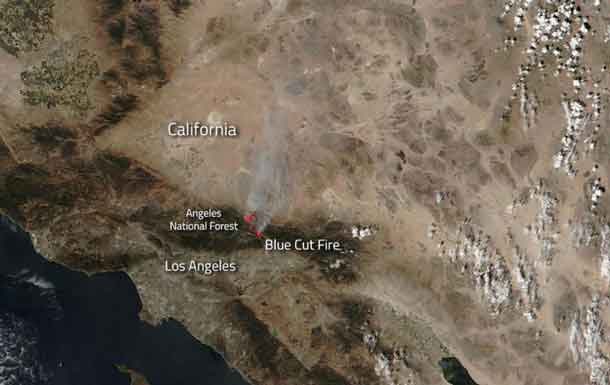

LOS ANGELES – Wildfire – The Blue Cut Fire, just outside of Los Angeles, is a quickly growing fire that is currently an imminent threat to public safety, rail traffic and structures in the Cajon Pass, Lytle Creek, Wrightwood, Oak Hills, and surrounding areas. An estimated 34,500 homes and 82,640 people are being affected by the evacuation warnings that have been issued. This wildfire started on August 16, 2016 and the cause is unknown. In the last two days the fire has grown to 31,689 acres with 1584 personnel on scene. 178 engines, 26 crews, 10 air tankers, 2 Very Large Air Tankers (VLATS), and 17 Helicopters, including night flying helicopters. Additional firefighters and equipment have been ordered and will be responding directly to the fire. An unknown number of structures are damaged and destroyed. A smoke advisory has been issued for portions of San Bernardino Country.
Unfortunately extreme weather is continuing in the area with hot, dry and breezy (20 mph with gusts to 30 mph) conditions. Very poor relative humidity will continue. All of these will hinder fire fighting efforts and may increase fire spread.
NASA’s Suomi NPP satellite collected this natural-color image using the VIIRS (Visible Infrared Imaging Radiometer Suite) instrument on August 17, 2016. Actively burning areas, detected by thermal bands, are outlined in red. NASA image courtesy Jeff Schmaltz LANCE/EOSDIS MODIS Rapid Response Team, GSFC. Caption by Lynn Jenner with information from Inciweb.
Suomi NPP is managed by NASA, NOAA and the U.S. Department of Defense.


