
THUNDER BAY – Mining – Bayfield Ventures Corp. (TSX VENTURE:BYV)(PINKSHEETS:BYVVF)(FRANKFURT:B4N) announce the completion of a maiden National Instrument (NI) 43-101 Technical Report and Mineral Resource Estimate on the Company’s Burns Block gold-silver project, in the Rainy River district in Northwestern Ontario.
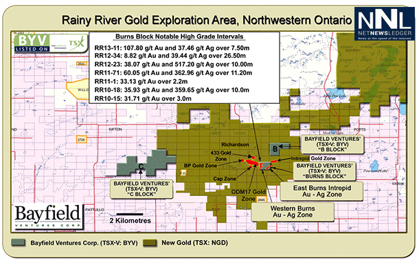
The Burns Block is surrounded by New Gold’s Rainy River project and adjoins the immediate east of New Gold’s multi-million ounce ODM17 gold-silver deposit and adjoins the immediate west of New Gold’s expanding Intrepid gold-silver zone.
Jim Pettit, CEO of Bayfield stated, “We are very pleased to announce our maiden resource estimate on our strategically located Burns Block, which reflects the quality and location of our resource and its potential to grow. Very early on the Bayfield team recognized that the mineralization on the Burns Block occurred in two stages, an early stage emplacement of lower grade material and a later stage of high grade which became the focus of our drilling, resulting in the discovery of two high-grade zones on the east and west sides of the property. This decision proved to be appropriate, as New Gold’s Rainy River mine plan has continued to pursue an underground component which has helped to raise their overall mine plan head grade. The Burns Block remains open at depth and the central portion of the property between our two high grade zones remains relatively untested. We have a resultant underground resource grade averaging greater than 7 grams per tonne gold. In light of the proximity and quality of our high grade underground resource to that of the adjacent New Gold deposits and our resources crossing the property boundaries, Bayfield believes its land and resources hold significant strategic value.”
Burns Block NI 43-101 Technical Report and Mineral Resource Estimate Highlights:
- An NI 43-101 compliant Technical Report and Mineral Resource Estimate has been independently prepared by Riverbend Geological Services (Riverbend) dated December 20, 2013 and titled BURNS BLOCK NATIONAL INSTRUMENT 43-101 COMPLIANT TECHNICAL REPORT.
- The NI 43-101 Technical Report and Mineral Resource Estimate lists both Indicated and Inferred resources in near surface positions (<500m depth, with a 0.35 AuEq g/t cutoff grade) and in deeper positions (>500m depth, with a 2.5 g/t AuEq cutoff grade).
- Combined Indicated resources have been calculated as 71,385 ounces of AuEq (Au & Ag) and Inferred resources have been calculated as 176,654 ounces of AuEq.
- Near surface (<500m from surface) Indicated resources have been calculated as 1.25 million tonnes of 1.0 g/t Au and 14.7 g/t Ag containing 39,928 ounces Au and 591,954 ounces Ag. Additionally, Inferred resources have been calculated as 2.79 million tonnes of 1.2 g/t Au and 14.4 g/t Ag containing 104,121 ounces Au and 1,293,763 ounces Ag.
- Deeper (>500m from surface) Indicated resources have been calculated as 79,000 tonnes of 7.9 g/t Au and 37.0 g/t Ag containing 20,029 ounces Au and 93,716 ounces Ag. Additionally, Inferred resources have been calculated as 195,000 tonnes of 7.4 g/t Au and 43.0 g/t Ag containing 46,475 ounces Au and 269,708 ounces Ag.
- Recommendations contained within the NI 43-101 Technical Report and Mineral Resource Estimate indicate the need for additional exploration drilling in the central portion of the Burns Block and additional delineation drilling on the Western Burns Zone and East Burns – Intrepid Zone of the property.
Burns Block Additional Discovery Potential:
The Burns Block is 80 acres in size and the majority of drilling has been concentrated on the western and eastern sides of the property. The central part of the property requires additional testing. The resources that have been identified cross the property boundaries onto the adjacent ground held by New Gold to the west and to the east.
Specific targets remain for additional discovery on the Burns Block. These targets can be grouped into four categories:
- Western Burns Zone: Additional drilling at depth on the Western Burns high grade zone would help fill in large holes in the model that have not been assigned a grade, due to a lack of data.
- East Burns – Intrepid Zone: Approximately 120 metres of strike length potential of the southwest plunging East Burns – Intrepid high grade zone remains untested along the southeast to south-central portion of the Burns Block.
- Central Burns Block Main Zone: Several holes collared in the sparsely drilled central portion of the Burns Block property have intersected 5 to 15 metre wide zones of low grade to gram level gold mineralization hosted within the sheared, foliated quartz porphyry dacite. These intersections have not been followed up and present the potential of being associated with additional undiscovered shoots of higher grade mineralization.
- Mineralized zones in both the hanging wall and footwall of the Main Zone: Completed drilling clearly shows the presence of multi-gram gold and silver mineralization in positions above and below the Main Zone. Several wide, significant mineralized zones lying below the Main Zone have been intersected but remain completely open due to lack of drilling. These targets are concentrated in the under explored central portion of the property.
Burns Block Geology and Mineralization:
Extensive gold-silver mineralization has been outlined on the Burns Block. Recent interpretations for the geology and genesis of gold mineralization on the Burns Block suggest an early, volcanogenic-associated model. Primary rock units in and around the deposit include dacitic flows and sedimentary volcaniclastic deposits. Additional data from exploration drilling showed that gold mineralization at the Burns Block has a strong gold-pyrite association, including ubiquitous sphalerite, and a very high ratio of silver to gold. There appear to have been two stages of gold mineralization in the Burns Block. The first (low to moderate grade) gold mineralization was associated with the emplacement of sulphide (pyrite-sphalerite-chalcopyrite) as veins and disseminations in dacite rocks. A later (high-grade) gold mineralization event included the emplacement of quartz-pyrite/chalcopyrite-gold veins and veinlets.
NI 43-101 Technical Report and Mineral Resource Estimate Summary:
As part of the study leading up to the report, the following data were obtained:
- Duplicate samples from core of low grade, medium grade and high grade mineralization.
- A large check sampling program was done by sending the coarse reject portion of samples of low grade, medium grade and high grade mineralization to an independent lab for confirmation check assaying.
- A rock density study from drill core was done including 400+ measurements.
- A compilation of detailed core photos of high grade mineralization intervals was prepared as a guide to high grade mineralization mineralogy and veining styles.
Riverbend was provided with all geologic mapping and stratigraphic data, logging data, original lab assay data and all core photography. Riverbend additionally acquired publically available technical reports, including NI 43-101 resource reports, filed by Rainy River Resources detailing study results for mineralized areas immediately west and east of the Burns Block.
Riverbend then proceeded to compile all data in order to proceed with the initial NI 43-101 compliant resource estimate. The result of the compilation and detailed computer based spatial study of the gold and silver mineralized zones at the Burns Block resulted in the identification of both Indicated and Inferred resource categories. Additionally, it was decided by Riverbend to separate the near surface, potentially open pit mineable mineralization from deeper, potentially underground mineable mineralization.
Riverbend selected separate cut-off grades for the shallow mineralization (<500m from surface) vs. the deeper mineralization (>500m from surface). A lower cut-off grade of 0.35 g/t AuEq was applied for the shallow, potentially open pit mineable mineralization. For potentially underground mineable mineralization, a much higher value for the cutoff grade of 2.5 g/t AuEq was selected to reflect the higher costs associated with typical underground development. For the purposes of the NI 43-101 Mineral Resource Estimate calculation, AuEq (gold equivalent) values are calculated at a 60 to 1 (silver price to gold price) ratio and metallurgical recoveries and net smelter returns are assumed to be 100%. These lower cut-off values for potential open pit and for potentially underground mineable mineralized zones are essentially identical to those used by Rainy River Resources for modeling of mineralized zones immediately adjacent to the Burns Block.
The results of resource calculations using the above stated cut-off grades are presented in the chart above. Note that the calculated resources listed above are separated into Indicated and Inferred categories and additionally into Potentially Open Pit Mineable (POP) and Potentially Underground Mineable (PUG) categories. Also note that no detailed economic mining parameters have been established for any of the mineralized zones at the Burns Block. The establishment of true economic parameters for estimating the potential to profitably mine any of the resources will require additional data collection and study which were beyond the scope of the current NI 43-101 resource report.
Cliff Duke P.Eng., principle of Riverbend Geological Services Inc., completed the Independent NI 43-101 Technical Report and Mineral Resource Estimate for the Burns Block and is an Independent and Qualified Person as defined by Regulation 43-101.
For additional documentation of the data and methodology used to establish the estimated resources in the above table please refer to the full report on SEDAR dated December 20, 2013: BURNS BLOCK NATIONAL INSTRUMENT 43-101 COMPLIANT TECHNICAL REPORT. The report will be filed on www.sedar.com within 45 days.
“B” Block Discovery Potential:
In other news, Bayfield has commissioned Riverbend Geological Services to complete an independent NI 43-101 compliant Technical Report on the Company’s “B” Block property.
The mine trend rock package is sharply deflected to the NNE along the western margin of the Black Hawk Stock and has been confirmed by Bayfield Ventures during limited 2013 diamond drilling on the “B” Block property. Logging results from diamond drill holes completed by Bayfield confirm the presence of iron formations, argillite units, hornfelsed, mafic tuffaceous sediments and well foliated quartz porphyry dacite intrusive rocks at the “B” Block property.


