
Snow Expected in Thunder Bay Saturday
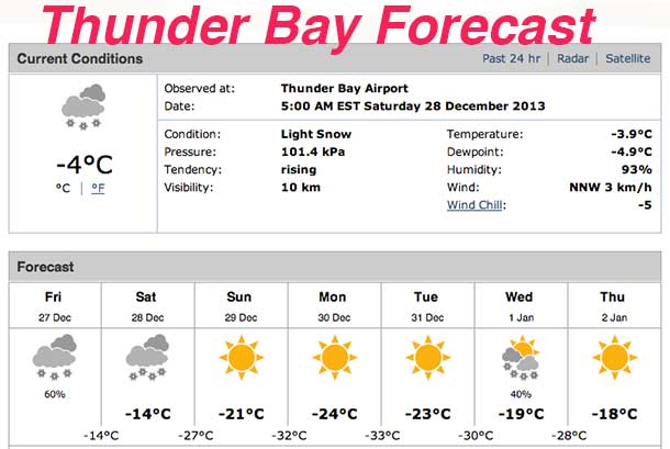
THUNDER BAY – News – Snow is in the forecast for Thunder Bay and much of Northwestern Ontario. An Alberta clipper is forecast to bring 10 to 15 cm of snow into the region. Extreme Cold is in the weather for the far north.
Environment Canada reports, “An Alberta clipper that brought a few centimetres of snow to the regions Friday is sailing away to the east, leaving mainly cloudy skies and scattered flurries in its wake”.
However another but stronger Alberta clipper is forecast to track southeast across North Dakota into Minnesota Saturday then likely into Wisconsin Saturday night. This disturbance is expected to bring a larger area of snow with it, reaching areas near the Manitoba border tonight then east to regions near Lake Superior including Thunder Bay on Saturday.
Total snowfall amounts of 10 to 15 cm are expected from this disturbance by Saturday night across Northwestern Ontario, and by Sunday morning across regions near Lake Superior.
Motorists should expect driving conditions to deteriorate and become hazardous at times from accumulating snow on untreated highways and lower visibility in areas of heavier snow.
Heading west, there are blizzard warnings in effect west of Winnipeg. Winnipeg has a snowfall warning in effect.
Extreme Cold in Far North
For Fort Severn and along the James Bay coast, cold wind chills of minus 45 to minus 50 are developing. Extreme wind chills of minus 50 or worse are possible by Saturday night.
Bitterly cold Arctic air combined with west to northwest winds of 15 to 30 km/h will cause wind chills of minus 45 to minus 50 to develop in the Big Trout Lake – Sachigo Lake region tonight. The cold wind chills may spread into the Fort Severn region by Saturday morning.
Even colder air will feed into the regions by Saturday night, with wind chills of minus 50 or lower quite likely across the entire district.


